RDRY
-
Posts
795 -
Joined
-
Last visited
Content Type
Profiles
Blogs
Forums
American Weather
Media Demo
Store
Gallery
Everything posted by RDRY
-
Latest observation: It' snowing.
-
Nice run, sans CRV.
-
But the globals are still better with surface and upper-level low location even at this range.
-
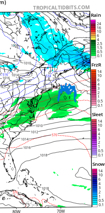
East tics have now taken the heavy band offshore On the GFS. It's 6-8 if that happens.
-
Won't be convinced unless the GRAF is on board.
-
All fun and games in here for this one.
-
Making that first post count.
-
Meanwhile, record-low seasonal snowfall in Colorado.
-
This thing is intensifying at the ideal time and position.
-
Busy with work -- just checked to see that we got NAM'ed. And a lot more wind than the January SWFE, obviously.
-
Looks like the trailing energy on the NAM dropped in to the base of the trough, pivoting the main system due north and even a bit northwest.
-
CMC 21 MB deeper than 18z at 78 hours. Models are still struggling with this evolution.
-
That trailing energy still punts the low out to sea.
-
(12) john jackson on X: "Lake Tahoe. Ho-lee sht. https://t.co/bQIJPtx2AK" / X
-
Huh. Checked the 18z and wasn't surprised it held firm. But then checked the AIs and
-
DC's second-biggest snowfall is 17.8 inches. I'm really just referencing the ridiculous amounts on the GFS for DC. Not happening.
-
Major climatological hedge against DC/Delmarva getting 2+ feet with a scrape for the northeast coast. I'm sure it's happened, but the extreme rarity convinces me this isn't close to the final iteration of this storm.
-

-
Okay. Game's back on.
-
The two pieces of energy in the northern plains were weaker and flatter on the 0z runs long before they ran into that confluence, which looks like an effect of the weaker trough, not a cause.
-
Expected a worse outcome from the early 500 MB panels. Shows what I know ...
-
First day of melting in the Berks since the big storm.
-
Can't win em all.
-
And a huge change with the west coast storm.