MountainGeek
-
Posts
544 -
Joined
-
Last visited
Content Type
Profiles
Blogs
Forums
American Weather
Media Demo
Store
Gallery
Everything posted by MountainGeek
-
Patchy flurries here as well, some flakes making it all the way down with instant stickage 19/4
-
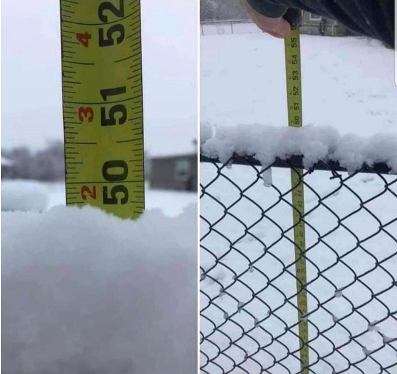
Hoping to measure between 49-50" - final call

-
PSU fringed!
-
Don't knock it -- I hear the CVS-Hi-Res nailed the temps in Augusta County this afternoon while the NAM was 10 degrees under actuals
-
You had me at "generally accurate for weather forecasting"
-
Right where we want it at this range - plenty of time to trend!
-
Well at least we have the CVS-Hi-Res in our favor.... They sell drugs to go along with the model output.
-
Light snow started about 15 mins ago
-
Oh dear....better hope @mappy doesn't see this......
-
They seem to be betting on more snow/sleet and less ice in the overall mix.
-
Ewe must bee knew hear....
-
Your write!
-
You must be new here.....
-

-
January Medium/Long Range: Chasing more snow to close out the month
MountainGeek replied to mappy's topic in Mid Atlantic
If you examine it more closely, it's actually saying that our temps are going to be the same as northern Alaska..... -
January Medium/Long Range: Chasing more snow to close out the month
MountainGeek replied to mappy's topic in Mid Atlantic
9 years ago today! (standing in the middle of the road with a mailbox in the background).
- 526 replies
-
- 14
-

-
January Medium/Long Range: A snowy January ahead?
MountainGeek replied to mappy's topic in Mid Atlantic
Need to send PSU out there to yell at it and convince it to move out..... -
January Medium/Long Range: A snowy January ahead?
MountainGeek replied to mappy's topic in Mid Atlantic
@Jebman - I don't even know where to begin - you are in freaking Texas!!! We're not talking a dusting here, folks. Oh no. You are going to get a "parade of plumes", a "bomb cyclone Tex-Mex fiesta" dropping white gold on cacti and tumbleweeds like it's trying to rewrite the state's weather legacy. Houston? Gone. Galveston? Forget it. Buda? It’s a snow and ice-encrusted snowy winter wonderland now. Models were SCREAMING about this for days, but who believed it? It’s Texas! The land of brisket, 100-degree football games, and air conditioners melting asphalt. Yet here we are. You will be buried in widespread 2" and locally higher amounts!!! Texas meteorologists are blinking like deer in headlights. DFW will shut down based on cold air alone. San Antonio is desperately trying to learn what the heck a snowplow is. Cars will be sliding around like penguins on Crisco. And you know the media will be losing its mind. "Historic Winter Blast!" “Arctic Apocalypse!” Jim Cantore might as well camp out on the Alamo steps at this point. Stock up on popcorn and watch Texans attempt to drive in this mess. A shoutout to the heroes who’ve never seen snow but are still trying to shovel their driveways with BBQ spatulas. @Jebman - this is your time - your moment - you alone can TEACH THEM HOW TO SHOVEL!!!! This cold will be dug in like a tick on a hound dog. Congrats Texas -- you’re the new Alberta for a week!! -
January Medium/Long Range: A snowy January ahead?
MountainGeek replied to mappy's topic in Mid Atlantic
Over/under for whether your cousin does better than DC did yesterday? -
1/19 - The Roulette Wheel 29 Black Storm - OBS
MountainGeek replied to DDweatherman's topic in Mid Atlantic
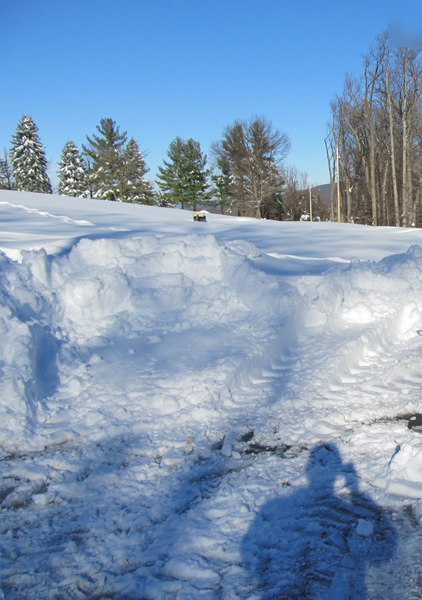
Finished just under 6" - trees heavily loaded with the initial batch of wet snow and then topped with powder -- gorgeous out there. -
1/19 - The Roulette Wheel 29 Black Storm - OBS
MountainGeek replied to DDweatherman's topic in Mid Atlantic
-
1/19 - The Roulette Wheel 29 Black Storm - OBS
MountainGeek replied to DDweatherman's topic in Mid Atlantic
Upgraded to quarters -
1/19 - The Roulette Wheel 29 Black Storm - OBS
MountainGeek replied to DDweatherman's topic in Mid Atlantic
Yup just pouring dimes 32/32 -
1/19 - The Roulette Wheel 29 Black Storm - OBS
MountainGeek replied to DDweatherman's topic in Mid Atlantic
Dumping snow here, it's coming just hang in there....you can dooo it! -
1/19 - The Roulette Wheel 29 Black Storm - OBS
MountainGeek replied to DDweatherman's topic in Mid Atlantic
Ripping, decent sized flakes - 32/32 - about 1" new snow on top of the existing snowpack