

Newman
-
Posts
1,991 -
Joined
-
Last visited
Content Type
Profiles
Blogs
Forums
American Weather
Media Demo
Store
Gallery
Posts posted by Newman
-
-
Yeah the Euro is solid for areas tomorrow night

-
 2
2
-
-
The GEFS is going to be slightly improved from the 6z run. There's at least some reflection of a HP up north now. It's not much, but something

-
3
-
-
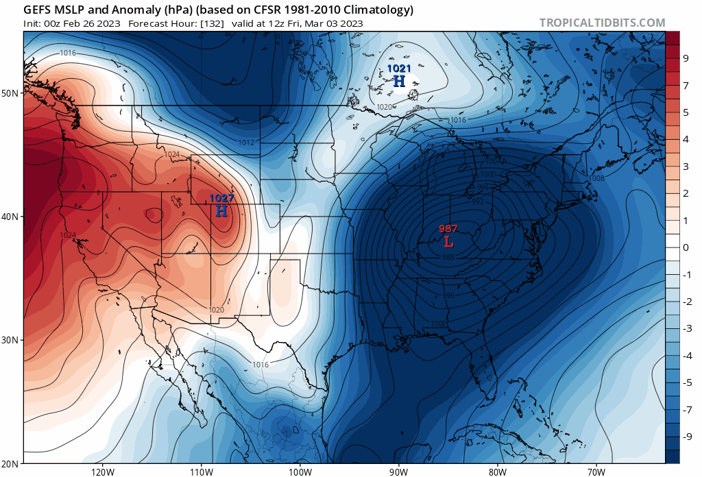
Canadian for late week storm


-
If the 6z NAM is right about temps today, then ChescoWx and Kamu might see mid-60s to near 70 while Redsky and Birds69 don't get out of the upper 40s

-
1
-
 1
1
-
-
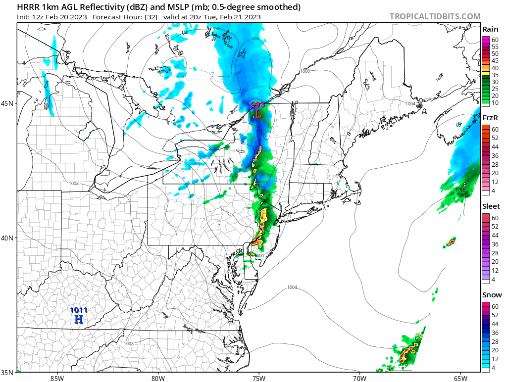
And there's even a tornado warning now right near Trenton, NJ. What a wild February day
-
 1
1
-
-
Tornado warning right near Trenton, NJ!
-
Was quite a gusty shower that came through Millersville like an hour ago or so. Lots of branches and small debris scattered everywhere
-
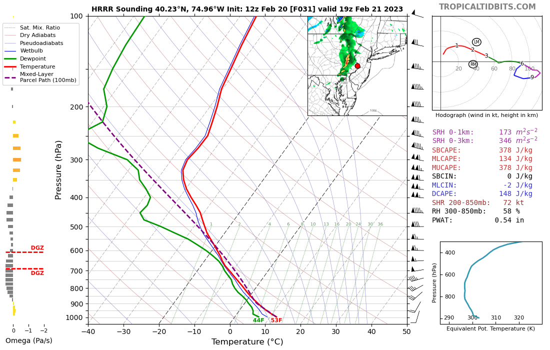
Tomorrow could be interesting with some strong showers/storms moving through in the afternoon. A very low freezing level of 850mb, steep low-level lapse rates, some SBCAPE, and a deep mixed-layer will give a shot for some thunder, small hail, and gusty winds.


Then we turn to Thursday where there will be a very legit shot for 70s across SE PA. The NAM, which is usually biased cold, even has it. Wherever the boundary sets up though will be the difference between mid-40s to the north and low-70s to the south

-
2
-
-
@RedSky I remember you talking about how cloudy it was everyday throughout January. Well, looks like SE PA had a top 10 cloudiest January
-
2
-
-
59 at midnight, will probably be the high for the day. Currently 51
-
We just hit 60 over here in Lancaster
-
Just hit 60 at MU, broke the record high for the date
Edit - Now 61
-
3
-
-
HRRR and RGEM are very bold in bringing mid-60s to parts of the area later today


-
1
-
-
I would be very surprised if many of us don't see 60s later today. No snowpack, NW wind will help downslope and dry things out. Full sun today, which is at an equivalent sun angle to Nov 2. 850s are +5 to +6.
-
Some occasional flurries here in Millersville
-
2
-
-
Euro is bone dry for the next week

-
1
-
-
Looks like we finished with around 2.5" in Fleetwood
-
1
-
-
2 minutes ago, BlueDXer75 said:
Looks like 2-3 inches in Sinking Spring. Still snowing moderately.
Yeah I think we have 2-3" in Fleetwood. I'm at nearly 800ft elevation compared to 300-400 feet down in Reading/Sinking Spring which helps alot
-
What's the totals so far up in Berks County? I'm down in Lancaster and my home cam in Fleetwood looks like at least 2"
-
And just like that the snow has stopped. It's not raining either, so maybe just a dry pocket
-
Def moderate snow here. Meso models fail, should've known better myself
-
2
-
-
3 minutes ago, so_whats_happening said:
Streets are starting to take on snow downtown started maybe 15 mins ago.
Slowly but surely they're turning more white here. Wondering if they'll cancel classes I really don't wanna go to Remote Sensing later lol
-
Just now, pasnownut said:
closing in on 1" here in etown. Heavy snow.
already a winner for me.
1" already out in Etown? Wow congrats! Crazy how just a small distance can make a huge difference
-
Roads are mainly just wet here, although some edges of pavement are turning white. Rates aren't that heavy I don't think for a full cave of the roads
E PA/NJ/DE Winter 2022-2023 OBS Thread
in Philadelphia Region
Posted
Latest HRRR... Mount Holly has issued a WWA for Lehigh County on north with only 1-3"