

Newman
-
Posts
1,990 -
Joined
-
Last visited
Content Type
Profiles
Blogs
Forums
American Weather
Media Demo
Store
Gallery
Posts posted by Newman
-
-
Are you guys in these yellow/orange echos?
-
1 minute ago, hazwoper said:
started as all snow here
Yeah maybe it was just a quick burst of sleet because now it's snowing pretty consistently here.
-
Snow and sleet has begun. I think most areas will start off with sleet/snow mix and then once the heavier echos come in then all snow.
-
-
Let's enjoy every flake guys. Not often we see snow in mid-November.
-
 1
1
-
-
I think virga will be kept to a minimum with that strong WAA push. There will be some, but not as much as we would normally expect with such dry dews.
-
The 3k NAM says watch out even down to Philly Friday morning around 6am as the ULL backside pulls through

-
On 11/12/2018 at 1:57 PM, Newman said:
My forecast at the moment would be:
Philly on SE to the coast C-2" at most of snow, mostly sleet so probably less, and then over to a chilly rain.
Philly on NW to the Lehigh Valley 2-4" of snow, to sleet and freezing rain, then ending as a chilly rain.
Lehigh Valley on NW into NE PA 4-8" of snow, then to sleet and freezing rain. Depending on low-level cold, storm may remain frozen throughout.
This all depends on initial onset of precip and how strong the low-level cold hangs on. I think sleet/freezing rain will be the predominant precip with the easterly winds off the coast in the mid-levels. In fact, my snow forecasts are probably too high but it's still 3-4 days away. The Ukie and Euro are much colder and snowier than the GFS and CMC.
This forecast still stands. Cut back for those SE of Philly to C-1" at most of sleet/snow.
-
1 minute ago, RedSky said:
18z NAM is plain ridiculous showing 10" to 1" west to east in Monmouth. Wherever i go the gosh darn fence will follow me.
Don't worry about the snow maps with this storm. The NAM shows 1.25" of liquid for a lot of SE PA. At 10 to 1 that's 12" of snow. Ratios will be 8 to 1 so make it 10 inches of snow. Cut it in half to account for sleet and you get 5" of snow and almost 2" of sleet and/or freezing rain accretion.
-
6 minutes ago, Ralph Wiggum said:
No changeover here on the NAM either until dryslotted then the usual 32-33f drizzle.
I'm hyped. It's only mid-November and we're tracking THIS. Check out the 700 fronto on the NAM. We all will be thumping heavy snow during the evening commute Thursday.


-
Wow the NAM keeps NW areas around the Lehigh Valley 90%-100% frozen throughout the storm. Lets go.
-
This map is more realistic:

Still, it's literally mid-November and we are tracking a legit snow/ice storm. Anything to cover the grass is a win for me.
-
3
-
-
Sun angle in November is pretty low so that's good. Temps will be down into the mid-upper 20s Wednesday night and Thursday morning. However, we might lose a lot of our initial precip to virga due to how low the dewpoints are.
-
Wow Bernie Rayno is all over this threat. He says the initial WAA isn't the main story but rather the CCB and ULL swing through on Friday morning. If you want to watch his periscope, it is on his twitter. He circled SE PA up into Central and Northern NJ and just north of NYC as the bullseye for potentially 3-6" and locally 8". He basically said to never ever trust a closed ULL.
Also, I'm sure you guys know that the 18z Para GFS snow map includes sleet. It would be nice to get 15" of snow in mid November but it's not happening lol.
-
My forecast at the moment would be:
Philly on SW to the coast C-2" at most of snow, mostly sleet so probably less, and then over to a chilly rain.
Philly on NW to the Lehigh Valley 2-4" of snow, to sleet and freezing rain, then ending as a chilly rain.
Lehigh Valley on NW into NE PA 4-8" of snow, then to sleet and freezing rain. Depending on low-level cold, storm may remain frozen throughout.
This all depends on initial onset of precip and how strong the low-level cold hangs on. I think sleet/freezing rain will be the predominant precip with the easterly winds off the coast in the mid-levels. In fact, my snow forecasts are probably too high but it's still 3-4 days away. The Ukie and Euro are much colder and snowier than the GFS and CMC.
-
2 hours ago, Ralph Wiggum said:
Probably wrong and I don't agree with it verbatim but the 6z gfs has a far NW burbs 'event' for Thurs-ish time frame. Looks like a sleet fest. Other guidance slower and less frozen.
Yep guidance is hanging back a piece of energy off of the Tuesday storm. If the great lakes low gets out of the way and the High Pressure up north trends stronger, which typically happens, then an inland CAD event could take shape next week before a bit of a warm up to end November. I expect "winter" starts 2nd week of December, but looking at the MJO progression, we could see a trough back in the east by very early December.
-
I think most if not all of us away from the coast will see snow in the 12-14th time frame. Whether accumulation occurs or not is still in the air but don't be surprised to see snowflakes next week.
Courtesy of NSFW Weather:

I would say the purple areas is actual accumulation and the blue areas is snow falling and/or coatings-1".
-
Congrats Western PA on the 18z GFS. Storm signal is there for something in the 14th-15th time frame.

-
1
-
-
49 minutes ago, Ralph Wiggum said:
The hemispheric factors you pointed out are certainly encouraging. However, how they will actually play out in terms of real weather at the surface and not just a nice looking index is the key here. What I dont like that I continue to see over and over on the 500mb anomaly charts that have been there since Sept and continue to be shown in the long range are the WAR that continues to surface......where we generally want to see a 50/50 during the winter months is in fact a repetition of a transient WAR feature. With that said, the fact the this feature (for now) is transient when it shows up should allow for some chances as time moves forward. But as I alluded to in my outlook, this feature is going to give the coastal plain fits as we will get our storms but those couple of degrees that we rely on with a 50/50 aiding us irt LLC may in fact favor those far NW burbs where traditionally and climatologically it is colder/snowier.
The other feature that is different than the past few years so far is the EPO feature or +PNA look (tandem). When we do see ridging out west and into Western Canada it has been getting easily squashed and displaced. In autumns past we have seen this feature being more of a persistent look and that allowed decent hints into the future of winter. Again tho, the feature is there sporadically.....just transient. So we will probably still get good looks during the winter, it will be a matter of timing.
With the analog seasons I used in the outlook thread, those winters had some of the same looks but when we had out chances, the timing just never came together and snowfall was BN in those winters for PHL proper but far NW burbs fared better. I cant say (nobody can) for certain how the timing will pan out this year but if you blend those analogs verbatim with all things equal, I am definitely not sold on the "winter of yore" thing for the coastal plain. Farther NW will fare better. Inbetween zones will see more sleet/mix this year than 'normal' seasons. Very warm SSTs off the coast probably wont help and this is where out wam layer comes from during coastal storms which traditionally do the damage in flipping snow to sleet etc.
So yes, some of the factors hemispherically that you pointed out do look decent as you noted, but how it all unfolds at the surface will be how we remember things come April 2019. We *should* see more storminess and moisture this year due to the Nino influence BUT there is alot more to it than just that alone.
One final thing I have seen repeated since about early September has been cool Canadian HP taking hold and giving the region BN temps and blue skies for a period followed by brief warmups (AN) with cutter-style storms going to our West and subsequent piece(s) of energy breaking off and sliding off the SE or redeveloping and being tucked or slightly inland. It's early but havent seen anything favorable thus far irt to timing of key pieces at 500mb and the surface. This could and probably will change as we head into the colder months. For better or for worse? TDB. You guys know where I stand by now.
I agree with all of your points and can see your hesitance. However, I believe the +PNA and EPO region will feature a predominant ridging pattern on the west coast. The warmer waters in the North Pacific should allow for a strong +PNA look throughout the majority of the winter, rather than having it be sporadic and transient. Just my opinion, however. One of my biggest concerns is the negatives out towards Hawaii. If the negatives pull west too much, then the western US ridge will be pulled too far offshore and the eastern trough will be oriented too far west in the Midwest and feature too many coastal hugging storms and/or deep interior show bombs. Basically where you see the EPS map above is where you want to see everything oriented. I would like to see -AO pop with blocking in the arctic region, trapping the trough underneath. However, the Scandinavian blocking should do the trick.
I love this look.

-
3
-
-
The colder water in the Indian Ocean is going to play big dividends this winter. If it persists, I don't see the MJO coming out of favorable phases 8, 1, 2 and 3 too often. Modoki continues to form, even saw a WWB earlier this week which will help build the SST's up a bit. Would like if the eastern areas of the ENSO were a bit colder. Long range shows trough in the east with chances of snow, even closer towards the coast. Scandi blocking is also evident and i would bet we see that alot this winter. I'm loving what I'm seeing heading into November and this winter at the moment.

-
Too many mets and knowledgeable enthusiasts to name specifically, but almost ALL winter forecasts I have seen expect a trough/colder weather on the EC and a snowier pattern. The ENSO state, solar state, EPO state, North Pacific Warm Blob, etc. all have corresponding analogs that point to a decent winter. I've seen 2002-03 thrown around a bit. The only worry I have is a lack of Atlantic cooperation and the heavy reliance on Pacific drivers. BUT, the Pacific is more important on our weather than the Atlantic is. I think we'll see the positives over the north pacific bridge across Canada into the NAO region regardless and trap the trough underneath. The QBO right now is negative and trending positive, a possible worrying feature but it is only one piece of the puzzle and will likely be muted out with the other factors. I think the pattern continues to step down rather traditionally into winter. I could see December being decent snowfall wise, January taking a bit of a break, and February/March rounding out the winter strong. We'll see if any SSWE begin to take shape this winter which could throw a wrench into the equation. Nice seeing some of you guys again!
-
Guys, the old GFS is completely on it's own now. EURO/UKMET/ICON/CMC/NEW GFS all landfall down into SC/NC. In fact the EPS members coming in right now are all into SC or NC as well. Could we get some gusty remnants later on? Sure. But a landfall north of the OBX is looking very unlikely at this point. Good luck to North Carolina on this one. The coastline is going to get destroyed by the MH force winds and inland will get 10-20" of rain. Insane really.
-
1
-
-
I haven't posted here much summer cause nothing has warranted me to. However, the flooding today in and around Berks County is incredible. Ponds and streams everywhere overflowing their banks and now making new streams and ponds. In other news, Joe Bastardi is calling for an epic winter. Already getting his unbearable and unneeded hype up for the winter season.
-
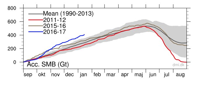
Could Someone explain why Greenland ice is at a record level with regards to surface mass balance? If there is any sign for this to decrease and get back to normal levels, what is it?

1st Winter Event of 2018-19 Fall/Winter Season
in Philadelphia Region
Posted
Dumping snow here. Probably have a half inch, maybe more.