

Newman
-
Posts
1,991 -
Joined
-
Last visited
Content Type
Profiles
Blogs
Forums
American Weather
Media Demo
Store
Gallery
Posts posted by Newman
-
-
-
Mid-60s for New Years Day anyone?

-
 1
1
-
-
Just cracked single digits, 9F
-
 1
1
-
-
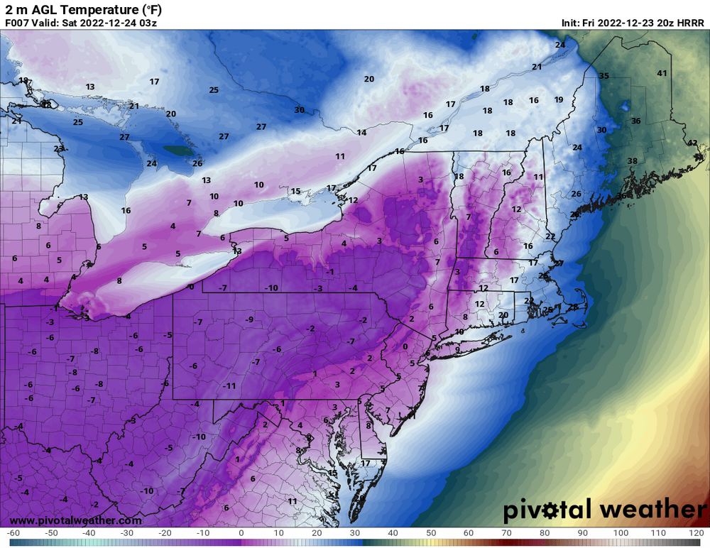
HRRR thinks I'm getting close to, or even touching 0 by 10pm tonight
-
2
-
-
12F, winds are blowin, it's nippy out there
-
Yeah flash freeze is no big deal here, only thing to worry about is a rogue wind gust knocking power out
-
3
-
-
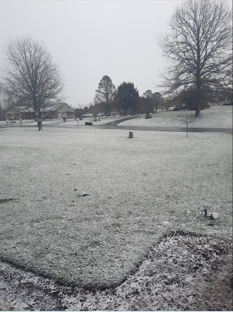
One last burst of mod snow now but can see the sun peeking through, 23F. Impossible to know how much fell with the blowing but it definitely looks like around a half inch
-
-
24F and snow has all but finished, a solid coating on the grass and cars. Roads look wet, I'll go check on the status of them here when I grab the trash can that flew into the neighbors yard
-
Temp has dropped all the way to 32 now with the snow. Mod snow and blowing. Only stickage on grass
-
@penndotguy You snowing down there in Reading yet?
-
Snowing here mixed with rain. 36F and dropping
-
1 minute ago, LVblizzard said:
Some backbuilding going on in eastern MD and SE PA. Wouldn’t be surprised to squeeze out an inch or two in the Lehigh Valley. Still raining here but that R/S line looks like it’s racing east.
You can see the wave riding up north on radar well, I too think I can get a half inch to inch here
-
Seeing the wind chill advisories issued for South Florida is hilarious... "Very cold wind chills of 30 to 35F". Kidding aside, that's pretty cold for that region. Still 42 here
-
 2
2
-
-
5 minutes ago, canderson said:
That’s awesome - congrats! Know where you’re headed yet?
Also gust to 46 just now.
My top 3 schools are University of Alaska Fairbanks, Wyoming, and Utah. So places that get real snow and winter! lol
Check out the loop here, you can see some sort of wave riding up along the front making it's way north. That's what the HRRR and NAM are showing as our changeover to snow.
-
2
-
-
2 minutes ago, canderson said:
nerd alert!
")
I'm a met student! Can't help it. Will have my red tag in a few short months when I graduate
Except I won't be around the area anymore heading to grad school, but will still try to engage in the subforum when I can
-
8
-
-
3 minutes ago, Bubbler86 said:
Yea, I was not trying to be persnickety, sorry. To me it looked like the front passed Harrisburg before 8AM. I had initially said it looked like it was in NJ but then I did see the WPC map was an estimate so I yanked that misconception, sorry. I do believe it takes a period of time from front passage for temps mixing down to the surface.
No you're all good, it was worth mentioning. I even pulled out my Atmospheric Dynamics notebook and textbook to read up again on fronts quickly and apply it to the current obs/situation.
Temp is dropping here, albeit slowly. Now 42
-
1
-
-
Just now, Bubbler86 said:
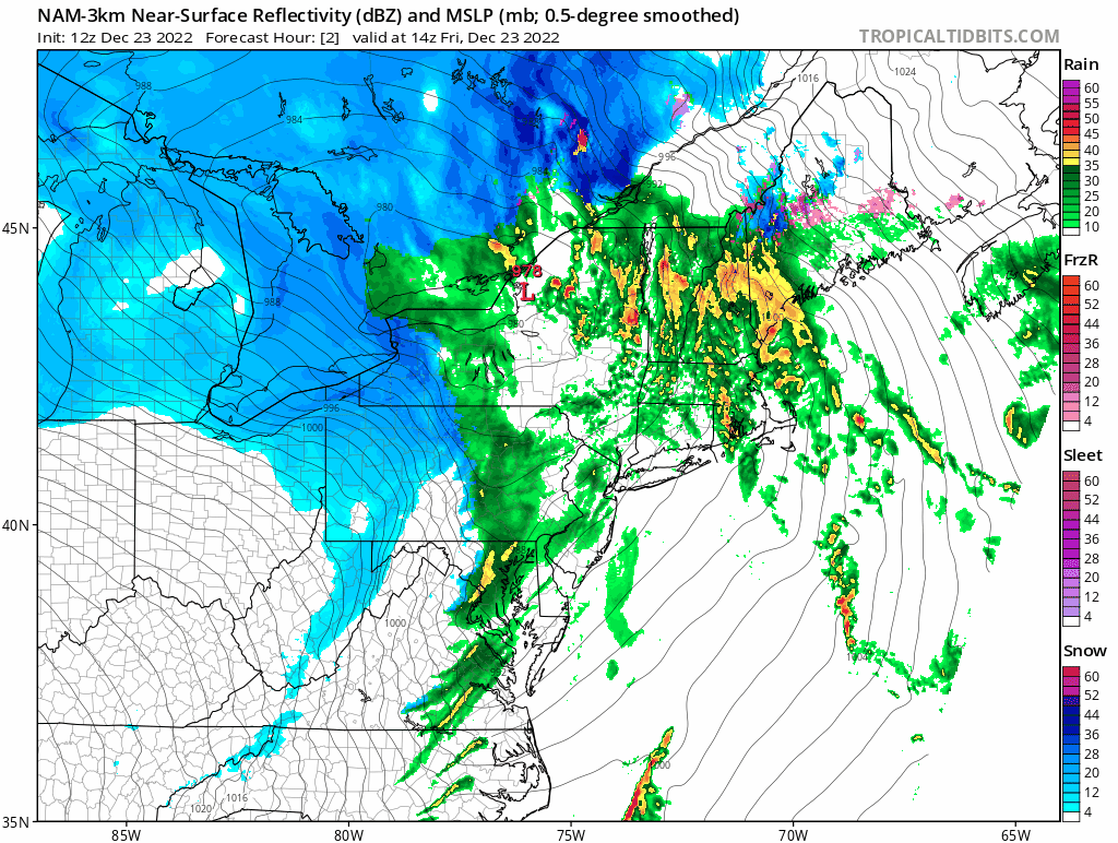
I was reading the surface ob's at Harrisburg as well. The DP started dropping slight before 8 so that would indicate the front had passed to me. But this is interesting as there is always a delay in temp drop from what I have seen. HRRR has back building of precip well after the front, so I was not just counting on the precip. HRRR has precip in MDT still at noon which is way past the front.
The 3k NAM also has that similar back building of precip into the area. Regarding the front thing... I checked a HBG wunderground site and the pressure was already rising there. So to be honest I'm confused too because there's mixed signals I'm getting. But also, it doesn't really matter because all we really care about is the snow haha

-
2
-
-
4 minutes ago, Bubbler86 said:
SPC/WPC is insisting the front is entering NJ right now FWIW. Wind direction here changed about 2 hours ago. Not that it really matters but the delay in temp drop is interesting.
That's super interesting. I think those figures (from SPC and WPC) are just rough estimates though because we wouldn't be seeing the band of rainfall moving through if the front was already into New Jersey. Physically speaking from a basic meteorological standpoint, the precipitation is always associated along and AHEAD of the cold front where you get rising motion above the cooler air mass. So it's definitely not your fault, but the WPC map is deceiving because the front is definitely not into Jersey yet
-
Just now, Blizzard of 93 said:
Multiple Reports in the Mid Atlantic thread saying flipping to snow now in areas just to the west of Baltimore & DC.
My friend in Leesburg VA is getting some snow now too
-
2
-
-
Winter Weather Advisory issued here
PAZ054-055-060>062-240315-
/O.NEW.KPHI.WW.Y.0020.221223T1409Z-221223T2300Z/
/O.CON.KPHI.WC.Y.0003.221223T2000Z-221224T1800Z/
Carbon-Monroe-Berks-Lehigh-Northampton-
Including the cities of Jim Thorpe, Stroudsburg, Reading,
Allentown, Bethlehem, and Easton
909 AM EST Fri Dec 23 2022

...WINTER WEATHER ADVISORY IN EFFECT UNTIL 6 PM EST THIS
EVENING...
...WIND CHILL ADVISORY REMAINS IN EFFECT FROM 3 PM THIS AFTERNOON
TO 1 PM EST SATURDAY...

* WHAT...For the Winter Weather Advisory, a strong cold front
  moving west to east across the area this morning will bring rain
  showers changing to a quick burst of snow with rapidly dropping
  temperatures. Snow accumulation will be limited to a half inch
  up to an inch and a half but it will fall in a brief period
  leading to a quick drop in visibility and icy conditions. West
  winds will also gust up to 55 mph. For the Wind Chill Advisory,
  very cold wind chills expected. Wind chills as low as 25 below
  zero.

* WHERE...Carbon, Monroe, Berks, Lehigh and Northampton.

* WHEN...For the Winter Weather Advisory, until 6 PM EST this
  evening. For the Wind Chill Advisory, from 3 PM this afternoon
  to 1 PM EST Saturday.

* IMPACTS...Plan on slippery road conditions. The hazardous
  conditions could impact portions of the morning and evening
  commute. Gusty winds could bring down tree branches and result
  in power outages. The cold wind chills could cause frostbite on
  exposed skin in as little as 30 minutes.

* ADDITIONAL DETAILS...The snow will be brief but icy conditions
  may linger through at least this afternoon.
-
1
-
-
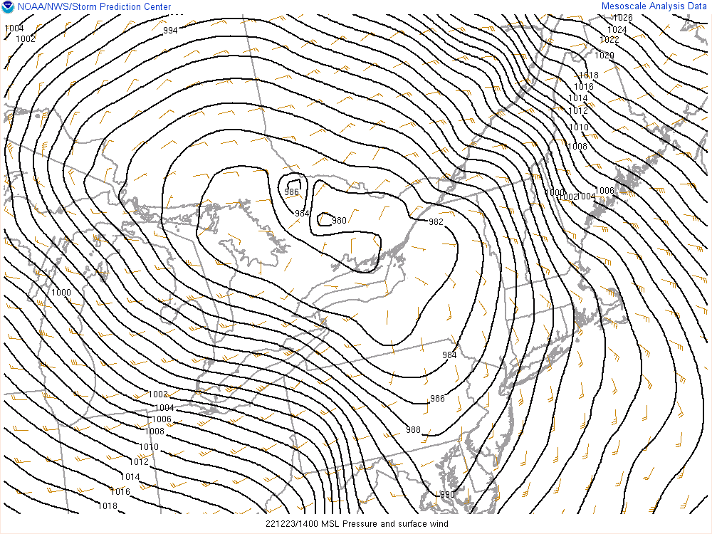
This is an incredible surface map. But look at the sagging of the isobars through the LSV, that's where the front is
-
1
-
-
Anybody flip to snow yet on the backside of the front?
Currently 42, down from a high of 56 at 2:30am. Pouring rain.
-
Made it to 56 around 2:30am, now down to 43 and patiently awaiting the front

December 22 - 25 possible historic wintery/mix/rain event obs
in Philadelphia Region
Posted
3.2F here now in Fleetwood. There's a weather station atop the Mount Penn Memorial Fire Tower in Reading that sits 120 feet above the ground currently reporting -0.1 degrees