

Newman
-
Posts
1,990 -
Joined
-
Last visited
Content Type
Profiles
Blogs
Forums
American Weather
Media Demo
Store
Gallery
Posts posted by Newman
-
-
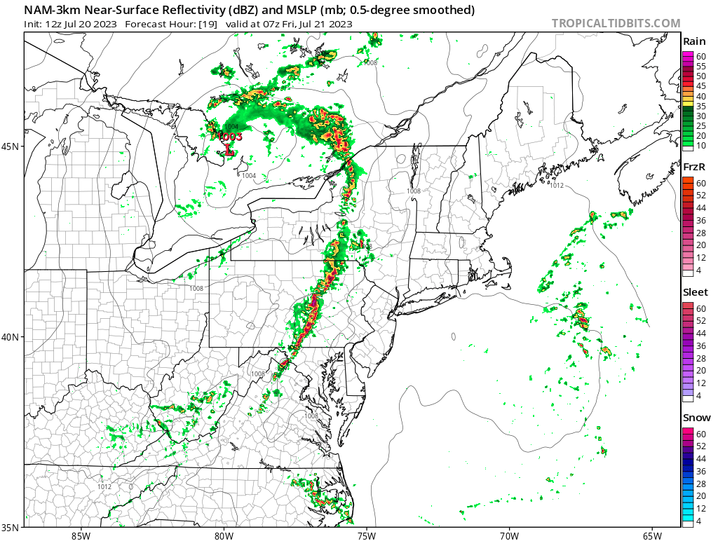
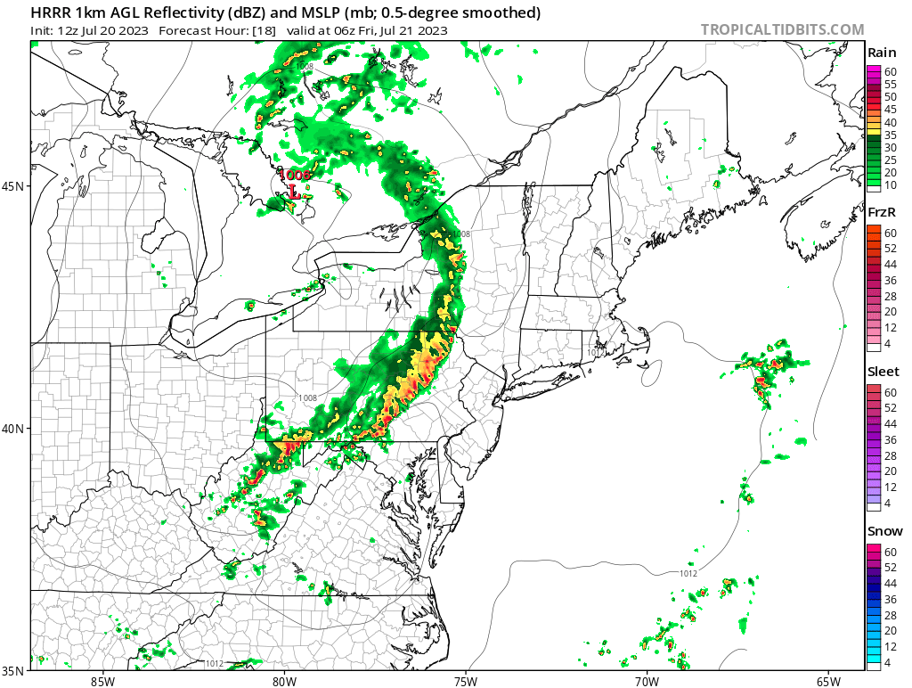
That warning heading towards Leesburg has a classic QLCS kink
-
 1
1
-
-
Yeah Harrisburg might get completely skunked. That discrete cell entering southern York is the real deal and has been tracking for awhile
-
The line entering Franklin is starting to bow out, warned for 70mph winds currently
-
1
-
-
You can see the squall line beginning to take form
-
Tornado warning for state college
-
1
-
-
Man those cells coming up into Franklin county are nasty. The VILs are huge and the hail cores have gotta be over golf ball size
-
Big discrete cell heading into southern Franklin county. Definitely some 1"+ hail in that I'd think
-
Could there be any worse time for the CCX radar to be down?
-
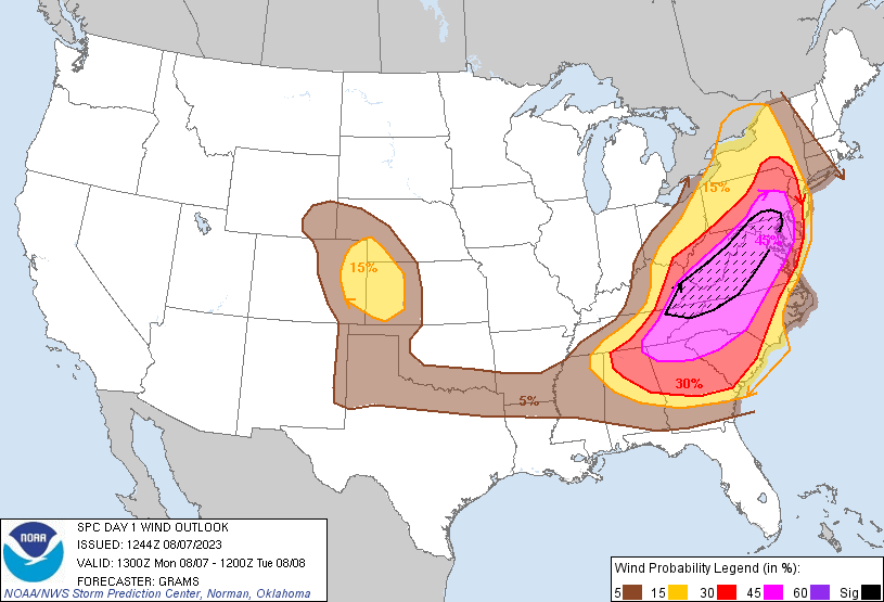
60% probs for 2 or more tornados (Mod), 30% probs of 1 or more strong tornado
-
1
-
-
The SPC MCD clearly says that the wind profiles should improve into the mid-atlantic over the next few hours in response of the rapidly approaching strong upper level and soon-to-form low level jet streak. Tornadoes are definitely a threat, though clearly wind is the biggest and everyone should know that.
-
9
-
 2
2
-
-
One of the most intense severe weather days predicted in like 10 years. Wish I was back east to experience it. Y'all are in for some wild weather today. Enjoy it and stay safe
-
1
-
1
-
 1
1
-
-
-
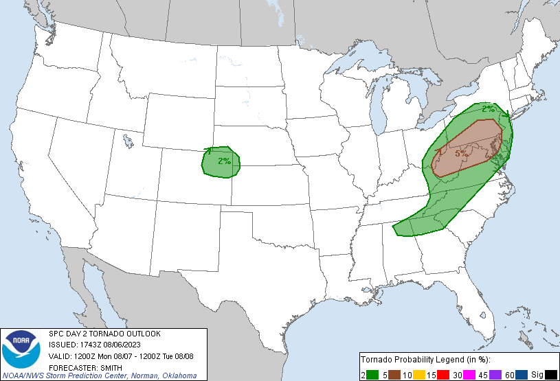
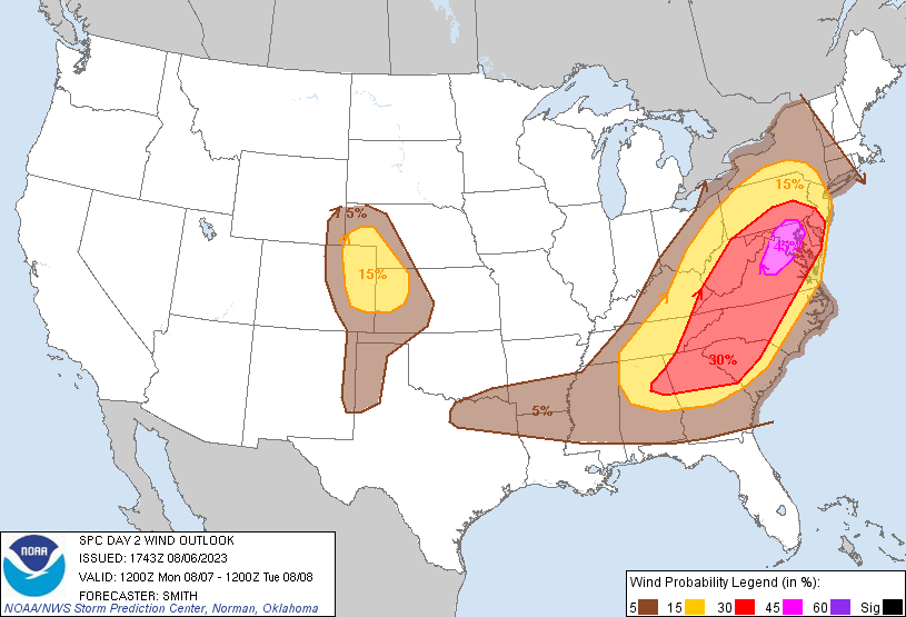
Some big time storms tomorrow. SPC expanded the 5% tor risk north and put up a 45%(!) wind probs risk over DC and far southern LSV. I think somewhere just south of the PA border would be ideal. The big question is if morning cloud cover inhibits afternoon sunshine. NWS and SPC discussion highlighting the likelihood of a bow echo and MCV forming hence the wind threat
-
30 minutes ago, KamuSnow said:
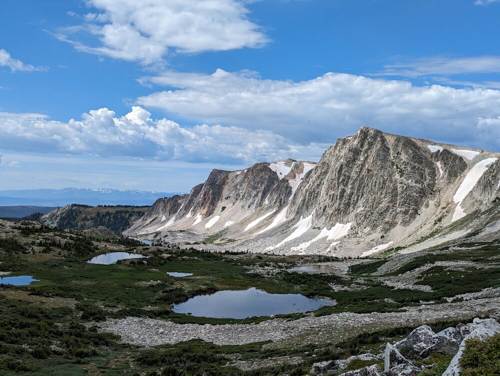
I can see why! So is that local local or 50 miles local? Beautiful either way. Had you been out there before? What's the elevation where that picture was taken? Good luck, and enjoy!
The picture is from a hiking spot about 45 miles outside of town, but speed limits here are 70-80mph so its not too far haha. I visited in April but this is my first time "living" out west. The peak of the rock cliff/mountain you see is 12,000 feet and the trail leads up that way, I was surprised to not get altitude sickness
-
1
-
-
Looks like the weather is quite comfortable back east in PA! It's been a rainy week since I've been here in Wyoming. Chances of storms/showers every day with a SW Pacific flow into the region. Was able to visit a local hiking spot this past weekend. I think I'm gonna like it here...
-
6
-
-
The SPC expanded the severe watch south to cover the entire LSV
-
3
-
-
SPC just extended the Severe watch for much of the CWA
-
1
-
-
-
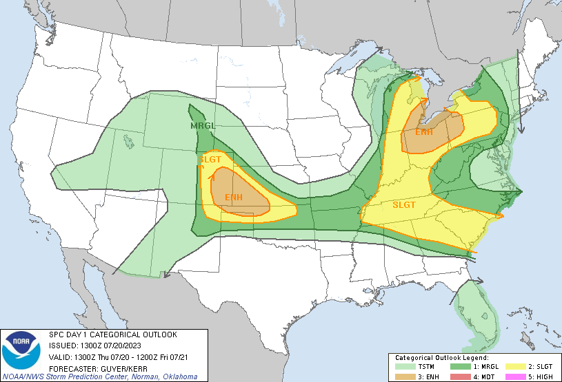
Could be a wild late night tonight with a line of storms rolling through between 1-4am. SPC has expanded a slight risk into the area for tonight's threat with mention of all hazards. There's a potent shortwave moving through north of us and we'll have a strong low level jet to sustain the squall and advect moisture/warmth overnight. NWS State College also highlighting a likelihood of severe level storms overnight

-
1
-
2
-
-
A couple trees down across York city according to some SPC storm reports
-
1
-
-
Quarter size hail reported in Lebanon with that storm that rolled through
-
2
-
-
On 7/9/2023 at 3:28 PM, RedSky said:
Where is Newman he looks like ground zero at the moment
Just got home from a backpacking trip near Williamsport. Left on Sunday and the last text I got from my parents before losing phone service was "Rain won't let up, been pouring for hours". Can't believe I missed a historic flood in my area.
-
1
-
-
14 minutes ago, CoolHandMike said:
2.4" in 40 minutes... flood warnings are up lol
There's a few wunderground stations with 3" of rain in and around Reading
-
Radar estimates of 1-2+ inches over Berks county over the last hour. Flash flood warning, PWATs through the roof
-
1
-
.gif.c1606da9f75842991e33d965d9857c99.gif)

Central PA Summer 2023
in Upstate New York/Pennsylvania
Posted
Line is really bowing out in Lancaster county, 70mph winds