
BooneWX
-
Posts
1,367 -
Joined
-
Last visited
Content Type
Profiles
Blogs
Forums
American Weather
Media Demo
Store
Gallery
Posts posted by BooneWX
-
-
These are really efficient storms today
-
 2
2
-
-
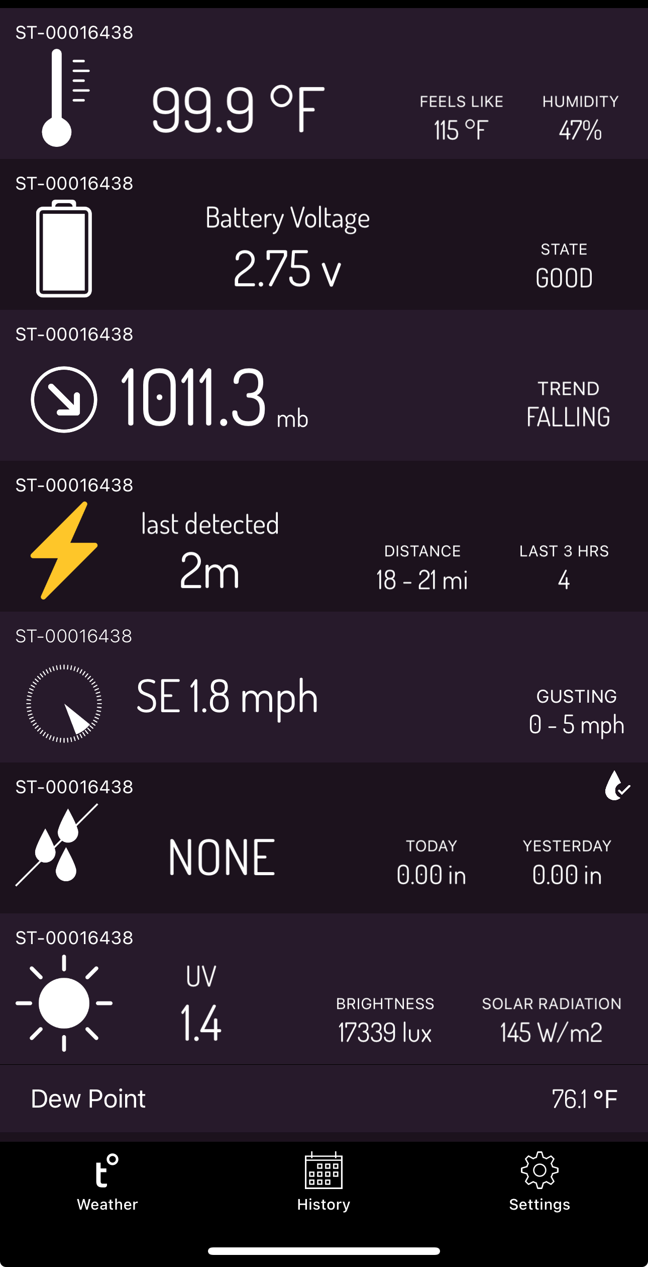
4.27” this week. The first week with over an inch since mid-May.
-
1
-
-
Blessings. Lost a lot of fescue to get here but maybe this will ease the pain a bit.
what are you guys doing these days grass wise? My yard has become a hobby over the years but these past two summers have worn me out with fescue. I have a baby at home and time just really doesn’t allow me to water it correctly and apply the fungicide needed. I can’t do Bermuda thanks to a shady backyard but thinking about Texas Bluegrass (southern hybrid to Kentucky bluegrass).
-
1 hour ago, NorthHillsWx said:
Regardless of exact daily records or just how hot Rdu is compared to other places, this has got to be a record hot summer. I cannot remember a summer with this many 100 and upper 90 degree days this early in the summer
You know it’s bad when TV Mets are billing relief as temps falling to the low 90s
-
1
-
 1
1
-
 1
1
-
-
Hot.
-
1
-
-
On 7/8/2024 at 8:35 PM, Silver Meteor said:
July 1st was indeed delightful in Eastern North Carolina. And then came the real July.
Hell on earth type of summer unfolding for everyone - even us foothill folks to your west. Glad yall will get some much needed rain this week, just don’t hog it all and be sure to share with the rest of the forum.
-
Also curious - where does this summer rank for you guys? We’re mid way through July and if next weeks temperatures verify, I’m getting close to crowning this as the worst and hottest summer I’ve seen.
-
1
-
-
Had a little over a half an inch on Sunday - the most since mid-May. It’s not nearly enough when we’re pushing 100 every single day of the week. My yard dying out sucks but I really feel for the farmers. I don’t think I’ve seen a corn crop look as pitiful as what I’ve seen the past few days in my life.
-
It’s getting that shrimp look
-
 1
1
-
-
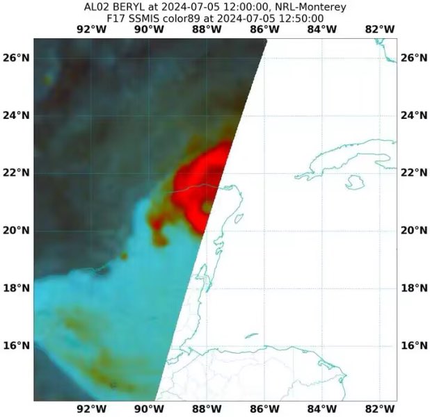
Plenty of time for this storm. It’s easy to forget it went from PTC to Hurricane in 24 hrs. It’s working with absolute jet fuel ocean water and it looks like it’s becoming stacked again and resisting the surge of dry air. Odds are a cat 1/2 but we’ve seen the RI in the gulf episodes too often to think it doesn’t have a shot at something higher. Hope folks in East Texas are paying attention.
-
2
-
 1
1
-
-
Aside, can anyone educate me as to why sea surface temps are always consistently cooler just off the northern Yucatán?
-
Storms fell apart again. I’ll continue my 4+ week streak of no appreciable rain for another day. Hoping the weather can warm up a bit and maybe we get higher dew points so we can overcome this severe lack of storm fuel.
-
Dear lord
-
-
I’ll be curious to see what’s left of the core in a few hours. It’s taken a beating but it’s already halfway across the Yucatán.
-
Beryl is a fighter and if the resiliency of this storm has showed us anything, East Texas should be bracing for the ceiling scenarios.
-
Ghost of Harvey….?
-
Happy 4th my foothill brothers.
-
1
-
-
Beryl could be an entirely different beast in the GOM if it continues its trajectory. It’s looking less and less likely that this thing hits the widest part of the Yucatán. If I’m in Texas, I’m getting a little sweaty this morning.
-
1
-
 1
1
-
-
-
I’m sort of wondering if the core is tightening due to friction with the land nearby
-
1
-
-
For kicks, the HWRF satellite depiction is an absolute truck tire annular hurricane in the gulf. It’d be quite the satellite presentation.
-
5 hours ago, LakeNormanStormin said:
But you know the precipitation will be displaced to the southeast and the Piedmont will get All the goods
Nothing defeats the dome around my house so you’re probably right!
-
1
-
1
-
-
928 on a recent drop…. Wow.
-
2
-

2024 Foothills Thread
in Southeastern States
Posted
Good soaking rain today, we really needed it. The thunderstorms have been great but I always think you lose a ton of water when it’s coming down at such heavy rates.