

BlunderStorm
-
Posts
1,122 -
Joined
-
Last visited
Content Type
Profiles
Blogs
Forums
American Weather
Media Demo
Store
Gallery
Posts posted by BlunderStorm
-
-
11 minutes ago, Windspeed said:
Downsloping off Clinch Mtn perhaps? There may also be downsloping off Holston Mtn, but I am far enough away that it isn't affecting me.
Yeah, that's pretty much it. This will be something I'll take account for in future events. Considering temperatures don't look to get significantly colder tonight this isn't going to stop anytime soon. I guess I could hope for some heavy rates to overcome but at the same time that's a double edged sword as it introduces more freezing rain to the ground and makes the situation worse. I'm expecting a pretty hefty glaze now. My only hope is for colder air in the upper levels to be forcibly advected into the valley which at this point is laughable. (refer to John's post above)
-
1 hour ago, Windspeed said:
Yeah, keep in mind that it is still really early and I hadn't originally expected a full changeover to snow until around 3-4AM at my location. I've got a slushy accumulation on everything that isn't pavement. Sleet/graupel mix with flakes right now. We're no where near the meat of the event and I expect the column will continue to cool despite the nose. May be near, perhaps after dawn before TYS sees anything significant as far as snowfall. KTRI should be all snow well before then.
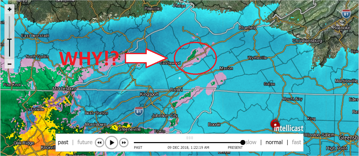
I don't understand what is causing the warm pocket over me. I feel like I'm in the worst location for miles around. Every short range models shows me under freezing rain all night. I checked the hourly forecast for Honaker and then I checked the forecast for Lebanon just a hop and skip down the road (It shouldn't look that different). Here is Honaker's hourly forecast: https://weather.com/weather/hourbyhour/l/24260:4:US Here is Lebanon's forecast: https://weather.com/weather/hourbyhour/l/USVA0426:1:US The thing is things are looking a heck of a lot more like Lebanon right now. It doesn't seem to be related to a warmnose in the upper levels of the atmosphere but rather it seems to be a local phenomena caused by local factors that still affect the upper levels. If the radar is right everywhere else in the region is getting hammered. I thought I could dismiss this look on the High-res models but noooo.... I just can't seem to win. It's one thing to be stuck in the situation deep in the valley with expectation of this. It's another thing to be surrounded by heavy snow on an upper level heat island "screw over zone" in a generally positive climate relatively speaking. I wish I had or at least knew how to access products that would show the current temperatures at the upper levels. I'm taking a direct slap to the face. I hope, I HOPE I'm wrong with this but it's looking likely this is how things go. As for assigning a term for this as I believe I mentioned earlier is this the downslope? Good luck everyone else I'll enjoy my long stay in ZR hell. I haven't been this frustrated with the weather in a long time.

-
The temp has dropped another degree to 34. It's got to the point where seeing it drop a degree feels like a small victory. As for precip type I'd say it's roughly 2/3rds graupel 1/3rd snow. EDIT: Make that 33 woo! It's finally back to where I started temperature wise good grief.
-
The temperature has dipped back to 35 and the dew point is jumping up to meet it. Heavy graupel is now being mixed with snow. It's getting there.
-
3 minutes ago, John1122 said:
I'm trying to be patient too. Models on most every run showed the changeover being around 3 or 4 am here and 7 to 8 am around Knox. But the early snow/slush falling got my hopes up early.
Glad to know I'm not the only guy with issues.
-
 2
2
-
-
The column has moistened enough for a steady light mix. I think I'm seeing every precip type under the sun all at once.
-
The lightest graupel has begun to fall finally. I trust the radar but golly is there some dry air underneath the level where it is scanning. This has not got off to a stellar start. It's going to be a fight. The temperature for whatever reason has now climbed to 36.
-
19 minutes ago, PowellVolz said:
How you going up with virga?
.Downslope off of Clinch Mountain maybe? It's not like I'm right next to it though. It took me forever to figure out what the Nam 3km, and HRRR were doing and now it all makes sense. Downslope. If you check the latest HRRR and look into SWVA you should be able to see it clear as day. Well that theory doesn't make sense on the ground at least. winds are coming from the NE at 4mph therefore it would not be as a result of downslope from Clinch mountain. Then again the wind direction could be drastically different further up in the atmosphere thus likely being the result of downslope. Then again if it were downslope I would see a rise in temperatures here which I am but the winds at the surface are not in that direction. I don't know I guess the clouds don't like me. lol.
-
1
-
-
2 hours of virga...why? It should be reaching the ground at this point. Is the atmosphere really that dry? Also the temperature has spiked up to 35 from 32 about 40 minutes ago ugh. Patience is a virtue...Patience is a virtue...Patience is a virtue.
-
It's all so close and yet it's a ghost town up here still. An occasional snowflake passes by every minute or two. I'm expecting it to really ramp up out of nowhere. I sure hope this is my last nada report haha!
-
7 minutes ago, Windspeed said:
I have heavy sleet coming down right now. Surprised as it's 39°. The column must be cooling rapidly. I am about 10 miles just south of Bristol.
If that's the case it must be knocking on my doorstep and wow sleet at 39... almost unheard of.
-
And... it begins. The first ice crystal has made contact with the ground. I'm watching this one out on the porch of my house in a heavy coat and enjoying the cold.
-
2
-
-
Just now, Windspeed said:
3k NAM is insane. Heavy snow in bright echoes for a long time over KTRI. This is going to be a monster run.
A great way to cap off the model viewing!
-
Radar is back to covering me but it's still virga. The relative humidity is at 68%. If anything starts falling now though it looks like it'll be snow with the temperature at 33F. Snow trucks are buzzing by like hornets around a nest.
-
2
-
-
How are things looking temperature wise above the surface right now guys? EDIT: Oh so I see we're switched 100% to obs got it!
-
Radar skipped the path up the valley to snow here. Still nothing falling and it is currently 34 degrees with the DP at 25.
-
Currently 36 with a soft breeze straight from the good old West Virginia Alleghenies to the northeast. The skies are solid overcast and as my mawmaw would say are "snowclouds". My high today was a balmy 37 and it's looking like it's only going down from here. I have my porcelain tile ready laid flat on the ground with a bit of dirt added underneath it to make the surface even on the slope of my yard, so measurements should be really accurate. It's all systems go as we got the shovels out and have the cars parked at the bottom of our driveway...We even got the bread and milk. BRING IT ON!

-
2
-
-
5 minutes ago, Shocker0 said:
We had some snow early this morning in Crossville. There hasn't been heavy precipitation all day though. It then started snowing again around noon today even with temperatures at 35 degrees. Interesting to see if we get anymore though. TWC insists on all rain the rest of the night with over an inch of rainfall, with snow eventually moving in tomorrow night. Would be nice to get a decent snow though.
TWC has been extremely dismissive east of the Blue Ridge. I'm not sure what model they were using this morning but they only gave Johnson City 0.5 inches of snow for the entirety of the event. Which at this point I think is laughable. So you may be in for more than you think but I can't say for sure everywhere varies.
-
2
-
-
Just now, AMZ8990 said:
I like how your totals got bigger when you had some doubts!

I can't help it... It's just been so long since I've seen a snowfall over 6 inches. The past two winters I have nickled and dimed my way to average-ish seasonal totals. Something is bound to go wrong and I just can't pin it down! Haha.

-
Just now, Windspeed said:
I have increased my expectations for the total at my location south of Bristol near the Holston River. My original thinking was 4-6" inches, but these late runs so close to event have me convinced to go higher. I expect 5:1, then 8:1 ratios as the column cools, then perhaps 10:1 between 7-10AM. Thinking 7-10 inches of cement. We'll be lucky to keep power with that.
My original thinking was 4-7 in when the NW trend began. Then I bumped my expectations to 5-8 last night. Now with some doubts i'm going with 6-10 in.
-
2 minutes ago, Carvers Gap said:
What a run of the 18z NAM...wow.
1 minute ago, McMinnWx said:It looks very favorable for the Valley.
It certainly isn't pulling any punches leading up to the event.
-
25 minutes ago, Mountian Man said:
I believe it is a tough call up my way. Still under a watch
In my opinion they should have called a winter storm warning hours ago for Mercer and Mcdowell. I'm feeling pretty confident the precipitation shield reaches there.
-
1
-
-
10 minutes ago, PowellVolz said:
Do you agree with me or am I off here? I’m thinking they may add everyone N and E of Knoxville to the WSW and go with an advisory for Knox Co.
.Tough question I've been mostly out for the morning and haven't really looked hard at the models. I'm feeling pretty confident they will put an advisory in Knox county. I'm not really sure they will implace a WSW North and East of there but I'm willing to bet they begrudgingly will. I would see the WSW brought down to Grainger, Union, Jefferson, and Sevier as the line.
-
1
-
-
Just now, PowellVolz said:
Supposed to be Gut instead of guy. Won’t edit for some reason
.Don't worry it did on my end.
-
1
-
December 8-10 Storm Discussion
in Tennessee Valley
Posted