

BlunderStorm
-
Posts
1,235 -
Joined
-
Last visited
Content Type
Profiles
Blogs
Forums
American Weather
Media Demo
Store
Gallery
Posts posted by BlunderStorm
-
-
18z NAM Low placement in the upper midwest is further south than 12z at 24 and is seemingly slower. Will see what that does downstream.
-
 1
1
-
-
3 minutes ago, Carvers Gap said:
Here is the 12z Canadian Kuchera compared to 0z
I would be elated if even 1/3rd of what the Canadian is showing came to fruition.
-
 2
2
-
-
12z Euro pops the low over NETN and SWVA.
-
1 hour ago, BuCoVaWx said:
Hey guys. Another long time lurker here. I live in SW VA, Buchanan County to be exact, on the KY state line. Maybe you can help with a couple of questions. First, am I in the right forums lol. Seems this one is closer to me. Second, will Grundy, VA have any luck with this coming system. By luck I mean snow accumulation lol. Thanks in advance!!
Yeah, you're in the right forum haha... Welcome aboard! It's good to have a fellow southwest Virginian in this neck of the woods! As for snowfall I would say things are looking fairly optimistic but there is a threat of the low pressure overrunning us and shifting the heaviest snowfall to our west. It's hard to say at this point.
-
0z Euro Control.

-
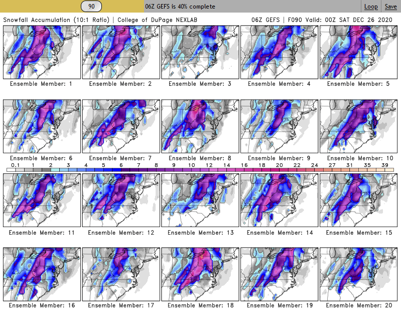
Here are the 20 GEFS ensembles for 06z.
-
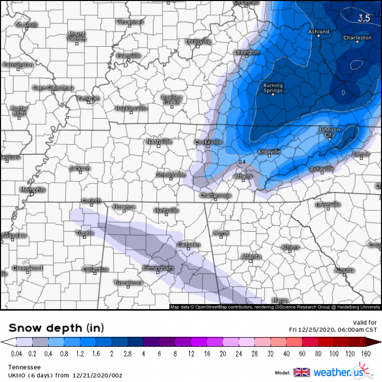
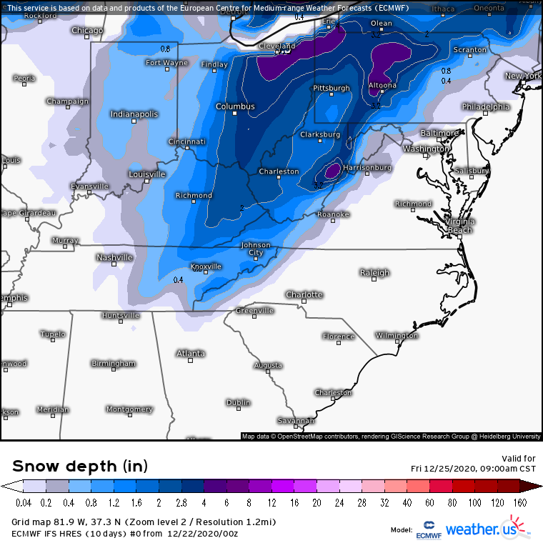
000
FXUS64 KMRX 220841
AFDMRX

AREA FORECAST DISCUSSION
National Weather Service Morristown TN
3:41 AM EST Tue Dec 22 2020
JB

.LONG TERM...(Wednesday through Monday)...
An active extended period with two main systems. One during the
Christmas Eve/Christmas Day and the next one at the end of the
extended. Will focus most of this discussion on the Christmas
system which will potentially be quite impactful. The main
messages are the following:

1) Strong upper dynamics will tighten the pressure gradient
across the southern Appalachians late Wednesday afternoon through
around mid-morning Thursday. Models agree with a strong 850mb jet
of 50- 60kts setting the stage for a Mountain Wave High Wind Event
for Mountains and Foothills.

2) Strong boundary layer southerly jet will also pull abundant
moisture into a strengthen upper jet dynamics to produce a 6 hours
period of moderate to locally heavy rainfall. Isolated runoff issues
are possible with localized flooding.  Not expecting a widespread
flooding event.

3) Strong cold air advection behind frontal passage between 12-16Z
Thursday will allow rain to change to snow quickly in the afternoon.
A window of light to moderate snow is expected Thursday afternoon
and evening, some locally heavy northeast Tennessee and southwest
Virginia. Accumulating snow is expected especially areas along and
north and east of interstate 40 and 75, as well as, the
mountains.

4) Strong cold air advection Thursday will drop temperatures quickly
in the afternoon with very cold airmass for Thursday night through
Friday night. Temperatures will be some 15 to 20 degrees below
normal for Christmas day.

Now for the particulars...

For Wednesday, upper and surface ridging moves east with increasing
boundary layer jet producing a mild day with increasing cloud cover,
mainly mid and upper levels. Strengthening frontal boundary over
western Tennessee late and continued ridging in the Carolinas will
begin to produce high winds late in the Mountains and Foothills.

For Wednesday night, A southern and northern stream jets will deepen
a long-wave trough across the mid-section of the nation. Strong
upper jet forcing will produce strong AGV/Omega along the frontal
boundary. The 850mb jet will be near 50-60kts with good 850mb
inversion to induce strong Mountain Wave High Wind event across the
Mountains and Foothills. The 850mb Omega shows strong subsidence in
this area depicting the affects of the Mountain waves. Have issued a
High Wind Watch for these areas.

For Thursday and early Thursday night, the brunt of the jet forcing
and strong Omega within the increasing elevated frontal boundary
(500-700mb) will produce widespread rain. Some of the rain will be
moderate to locally heavy. The strong jet forcing will greatly
strengthening the frontal boundary with strong cold air advection
changing rain to snow across the entire area. However, the best mid-
level Omega, negative EPV of -0.5 to almost -1, and affects of
strengthening surface cyclogenesis will be across southwest
Virginia and northeast Tennessee.

These areas will likely see the heaviest of the snow accumulations
with some banding of the snow possible for a brief period of time.
Significant snow accumulations of 2 to 4 inches are possible there
and far east Tennessee Mountains. Snowfall of 1/2 to 1 1/2 inch
possible across the northern Plateau into the central Valley. Little
to no accumulations elsewhere.

A Winter Weather Advisory may be needed for these areas if the
system persist for later runs.

For Christmas day, Snow showers or flurries will remain possible
across southwest Virginia and northeast Tennessee, and Mountains.
Another spoke of cold air aloft will also aid in the production of
snow showers northeast. Additional light accumulations possible
across the higher elevations. Main weather story will be the
abnormally cold temperatures.

The cold temperatures will persist Friday night and Saturday
morning, but moderate for Saturday into Sunday as upper trough
moves east.

For late Sunday through Monday, another system will move into the
Ohio and Tennessee valleys. A mixture of snow and rain possible
early, then changing to all rain.

DH
-
06z RGEM trending up for most areas! Western areas around Nashville east til the plateau would have got off better if not for some sleet. As an added bonus the run ends Christmas afternoon with widespread snowshowers still all over the plateau and NETN.

-
3
-
-
06z NAM trending up!

-
2
-
-
It would seem from this point going forward we have two camps. One with the Euro/Ukie/Icon and the other with the GFS-NAM/CMC-RGEM with the delineation being how quickly the arctic air catches the frontal moisture. EDIT: I just realized this probably looks like a cluster#### on mobile. xD


 VS
VS


CHRISTMAS CAGE MATCH-
 4
4
-
-
-
Summed up the Euro sticks to it's guns for 0z. MSLP is very similar with the leeside low really only getting it's act together in WV. The head of the front remains well ahead of the 540 line making it hard for anything wintry to really get going until it's well into the mountains and hitting NETN.
-
 1
1
-
-
If only Dr. Schmaybe could live up to our expectations... Let's see what 0z has for us!

-
1
-
1
-
-
Clinch Mountain the Fun Killer. Considering this one is approaching at another angle it's unlikely we get a repeat per se.

-
2
-
 1
1
-
-
https://ibb.co/wNq9B68 @John1122 thought I would put this up here for anyone interested.
-
3
-
2
-
-
Oof. GFS a little warmer and it develops the leeside low in WV instead of NC. Could be a lot worse though...imo. Maybe the Euro will meet it in the middle.

-
9 minutes ago, Holston_River_Rambler said:
NAM NAMed you @BlunderStorm
Not great for the rest of us in East TN, but that is the best the NAM has looked so far:
(past 3 runs trend):
...and so the model consolidation begins just like clockwork. Also yeah I noticed I got slammed but didn't wanna rub it in.

-
2
-
-
With energy associated with our system reaching the west coast we should probably get a clearer picture with 18z and 0z. Granted I doubt we have the best readings in the Yukon compared to Washington lol. Expect models to cave soon.
-
Not quite this hopeless but felt like sharing again.


-
3
-
-
12z and 0z comparison.
.thumb.png.5ed489d9cd5d5f552b34d5d14eabc942.png)
.thumb.png.114d28548e1453a1053f43f97438c955.png)
-
1
-
1
-
-
Surface temperature gradient behind the front is more gradual at 72 compared to 12z. Not a good initial sign.
-
1
-
-
3 minutes ago, John1122 said:
If we can land the cold, that is great. If not, I don't want mixing issues and warm noses anywhere around.
Hmm...
 Perhaps... more potent cold = stronger front = front dives further down in latitude = low develops in more favorable location =
  ?
?
-
1
-
-
0z ICON at noon on Christmas Day for anyone curious.

-
1
-
-
Now that it has initialized 0z Ukie is a big improvement from 12z... (Not where we want it yet but woo!) The difference maker was getting the developing low to the east of the blue ridge allowing for the coveted leeside low.

-
3
-


.png.1e46d2e8731c989cc0a1b9df31a20f4d.png)
.png.1ea4918a092ff6215493f09e5427aeb5.png)


Dandridge Dollop 12/24/20 Storm Thread (Winter Wonderland)
in Tennessee Valley
Posted
RGEM Rolling.