

BlunderStorm
-
Posts
1,122 -
Joined
-
Last visited
Content Type
Profiles
Blogs
Forums
American Weather
Media Demo
Store
Gallery
Posts posted by BlunderStorm
-
-
4 minutes ago, Carvers Gap said:
FWIW, the 0z GEFS ensemble mean is a pretty decent improvement from 18z.
Yep. Not sure what it's ensemble members are smoking in the deep south though...


-
3 minutes ago, John1122 said:
Christmas morning at 7. Still bands of snow in the valley region at this point.


-
 2
2
-
 1
1
-
-
6 minutes ago, snowbird1230 said:
Now to see how bad the GFS screws all this up...shes rolling
The GFS is holding the line of significant snowfall and pushing it south and west.
-
2
-
-
Just now, Stovepipe said:
You know with the heavy rains prior to the snow, and the temps crashing to such a degree, brining the roads isn't really feasible. People trying to travel for Christmas might be in for a bad state of affairs with 1 to 2 inches of snow on the roads, not to mention 2 to 4.
Not to mention the fact that snow aside with such a powerful front passing through you could easily get a flash freeze on bridges causing wrecks.
-
3
-
-
2 minutes ago, PowellVolz said:
A friend of mine just sent me a picture from Memphis of it hailing there
If you squint hard enough and ignore your windows being busted I reckon that counts as snow...
 West TN cashing in after all!
-
1
-
1
-
-
I'm rooting more so for a strengthening of the leeside low than it trending west, being probably the east most fella here haha. Better to expand the precip shield behind the front than shift it and delay it imo.
-
2
-
-
Non-Rushed Dandridge +3KM Version.

-
2
-
2
-
-
NAM Rolling!
-
2
-
3
-
-
7 minutes ago, Dsty2001 said:
So are we thinking at this point this has a greater chance of busting low or busting high lol
These may be some words I regret but with how the meso models have been trending along with the consistency of the globals I'm gonna roll the dice and say if this storm busts... It's gonna bust the roof off the forecast.
")
-
2
-
-
37 minutes ago, anonymous1968 said:
So, we are traveling from to and from Bluefield from Kingsport tomorrow. What time should we be back home and off the roads?
You'll probably want to leave in the early to mid morning just to be safe as it will probably rain heavily throughout the whole trip. I would recommend not being out any later than 3 PM. As you will be driving west towards the approaching front heading back.
-
Any good trends this morning?

-
1
-
2
-
-
Christmas morning.
06z RGEM vs 06z NAM

-
1
-
-
One thing I noticed on the doomcast HRRR 0z is the division of the front into two waves that hit hours apart as the day progresses. How and why is beyond my understanding but one quick look at the NAM 3km in comparison doesn't show that present. Perhaps something to look out for. (Both screensnips taken at 15z)
Check it out yourself on the models. EDIT: Adding to my confusion 6 hours prior and earlier looking at the presentation of the front with 2m temps it appears stronger and more progressive than the NAM 3km.
-
3
-
-
2 minutes ago, AMZ8990 said:
Interesting Update but you would think they would at least relent and lay down some winter weather advisories north and east of TRI.
-
1
-
-
13 minutes ago, Daniel Boone said:
How strong are the winds progged to be with this ?
May have a few hours somewhere around the realm of 12-15 MPH sustained intermittently with maybe some gusts in the 20s. That's the vibe I got from the NAM and RGEM at least. Per usual the eastern valley alongside the base of the blue ridge is a little more impressive.
-
1
-
-
-
18z NAM Low placement in the upper midwest is further south than 12z at 24 and is seemingly slower. Will see what that does downstream.
-
 1
1
-
-
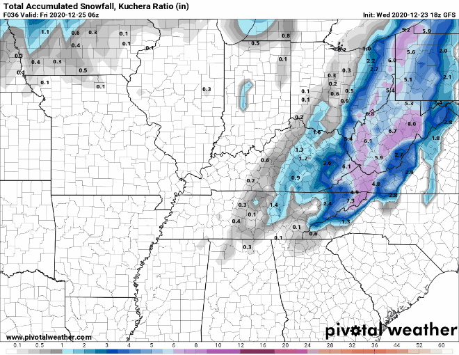
3 minutes ago, Carvers Gap said:
Here is the 12z Canadian Kuchera compared to 0z
I would be elated if even 1/3rd of what the Canadian is showing came to fruition.
-
2
-
-
12z Euro pops the low over NETN and SWVA.
-
1 hour ago, BuCoVaWx said:
Hey guys. Another long time lurker here. I live in SW VA, Buchanan County to be exact, on the KY state line. Maybe you can help with a couple of questions. First, am I in the right forums lol. Seems this one is closer to me. Second, will Grundy, VA have any luck with this coming system. By luck I mean snow accumulation lol. Thanks in advance!!
Yeah, you're in the right forum haha... Welcome aboard! It's good to have a fellow southwest Virginian in this neck of the woods! As for snowfall I would say things are looking fairly optimistic but there is a threat of the low pressure overrunning us and shifting the heaviest snowfall to our west. It's hard to say at this point.
-
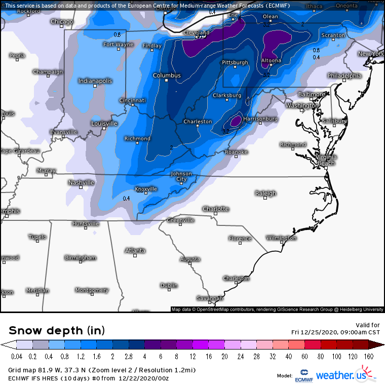
0z Euro Control.

-
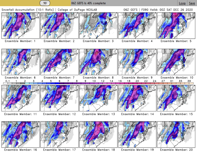
Here are the 20 GEFS ensembles for 06z.
-
000
FXUS64 KMRX 220841
AFDMRX

AREA FORECAST DISCUSSION
National Weather Service Morristown TN
3:41 AM EST Tue Dec 22 2020
JB

.LONG TERM...(Wednesday through Monday)...
An active extended period with two main systems. One during the
Christmas Eve/Christmas Day and the next one at the end of the
extended. Will focus most of this discussion on the Christmas
system which will potentially be quite impactful. The main
messages are the following:

1) Strong upper dynamics will tighten the pressure gradient
across the southern Appalachians late Wednesday afternoon through
around mid-morning Thursday. Models agree with a strong 850mb jet
of 50- 60kts setting the stage for a Mountain Wave High Wind Event
for Mountains and Foothills.

2) Strong boundary layer southerly jet will also pull abundant
moisture into a strengthen upper jet dynamics to produce a 6 hours
period of moderate to locally heavy rainfall. Isolated runoff issues
are possible with localized flooding.  Not expecting a widespread
flooding event.

3) Strong cold air advection behind frontal passage between 12-16Z
Thursday will allow rain to change to snow quickly in the afternoon.
A window of light to moderate snow is expected Thursday afternoon
and evening, some locally heavy northeast Tennessee and southwest
Virginia. Accumulating snow is expected especially areas along and
north and east of interstate 40 and 75, as well as, the
mountains.

4) Strong cold air advection Thursday will drop temperatures quickly
in the afternoon with very cold airmass for Thursday night through
Friday night. Temperatures will be some 15 to 20 degrees below
normal for Christmas day.

Now for the particulars...

For Wednesday, upper and surface ridging moves east with increasing
boundary layer jet producing a mild day with increasing cloud cover,
mainly mid and upper levels. Strengthening frontal boundary over
western Tennessee late and continued ridging in the Carolinas will
begin to produce high winds late in the Mountains and Foothills.

For Wednesday night, A southern and northern stream jets will deepen
a long-wave trough across the mid-section of the nation. Strong
upper jet forcing will produce strong AGV/Omega along the frontal
boundary. The 850mb jet will be near 50-60kts with good 850mb
inversion to induce strong Mountain Wave High Wind event across the
Mountains and Foothills. The 850mb Omega shows strong subsidence in
this area depicting the affects of the Mountain waves. Have issued a
High Wind Watch for these areas.

For Thursday and early Thursday night, the brunt of the jet forcing
and strong Omega within the increasing elevated frontal boundary
(500-700mb) will produce widespread rain. Some of the rain will be
moderate to locally heavy. The strong jet forcing will greatly
strengthening the frontal boundary with strong cold air advection
changing rain to snow across the entire area. However, the best mid-
level Omega, negative EPV of -0.5 to almost -1, and affects of
strengthening surface cyclogenesis will be across southwest
Virginia and northeast Tennessee.

These areas will likely see the heaviest of the snow accumulations
with some banding of the snow possible for a brief period of time.
Significant snow accumulations of 2 to 4 inches are possible there
and far east Tennessee Mountains. Snowfall of 1/2 to 1 1/2 inch
possible across the northern Plateau into the central Valley. Little
to no accumulations elsewhere.

A Winter Weather Advisory may be needed for these areas if the
system persist for later runs.

For Christmas day, Snow showers or flurries will remain possible
across southwest Virginia and northeast Tennessee, and Mountains.
Another spoke of cold air aloft will also aid in the production of
snow showers northeast. Additional light accumulations possible
across the higher elevations. Main weather story will be the
abnormally cold temperatures.

The cold temperatures will persist Friday night and Saturday
morning, but moderate for Saturday into Sunday as upper trough
moves east.

For late Sunday through Monday, another system will move into the
Ohio and Tennessee valleys. A mixture of snow and rain possible
early, then changing to all rain.

DH
-
06z RGEM trending up for most areas! Western areas around Nashville east til the plateau would have got off better if not for some sleet. As an added bonus the run ends Christmas afternoon with widespread snowshowers still all over the plateau and NETN.

-
3
-
Dandridge Dollop 12/24/20 Storm Thread (Winter Wonderland)
in Tennessee Valley
Posted
Yes, it usually begins it's run at 12:50 so we should be wrapped up for 0z at 1:00.