

BlunderStorm
-
Posts
1,121 -
Joined
-
Last visited
Content Type
Profiles
Blogs
Forums
American Weather
Media Demo
Store
Gallery
Posts posted by BlunderStorm
-
-
That was a hell of a game between the Jags and Cowboys. Congrats @jaxjagman
-
 1
1
-
 1
1
-
-
Pressure marginally higher at 42 on the Euro between the highs.
EDIT: By 60 the difference is more discernable, the low may pop up further east giving western folks more to work with. Let's see...
EDIT: At 78 discouragingly a low in hudson bay is stronger perhaps weakening the bridge of high pressure.
EDIT: 96, Welp, this probably won't resolve well. Looking very cutty, very quickly.-
1
-
-
11 minutes ago, Dsty2001 said:
We are still a good 5 days out
We're gonna need a hail mary of an eastward trend, that or some trailing energy once the low wraps the cold in.
-
1
-
-
6 minutes ago, Wurbus said:
No offense taken....in all likelihood I jumped the gun creating the thread since it usually doesn't pan out for us the closer we get to a potential event. I just have that feeling about this one though and if it doesn't pan out, I will never create a thread again for cursing the storm.
")
Honestly I had my finger on the trigger for sparking one tonight, so don't feel too anxious about it lol. As for expectations if I can get a white ground under marginal temps for Christmas I'll call it a W. Of course that's an easier feat up here.
-
10 minutes ago, TellicoWx said:
GFS said hold my beer lol
Almost all the cold of the Canadian but with a sub-forum wide snowstorm to boot. Honestly if something akin to that verifies a good snowpack would probably even things out low temps wise. I'd eat my gloves if the canadian verified and pulled off -10s in KY without a snow layer.
-
3
-
-
It would seem general consensus for a storm is still elusive. The GFS fell in line so now for 12z it's the Canadians turn to be Dr. NO. That said it seems to evolving closer to the GFS with the overall progression in the southern stream trending north. Hopefully the high stays further west for this slightly later window so it isn't dashed into the Atlantic.
-
1
-
-
18z has Santa coming in with a Stone Cold Stunner!
-
3
-
-
Currently 29.7 with light snow showers. This marks my first accumulation for the season.
-
4
-
1
-
-
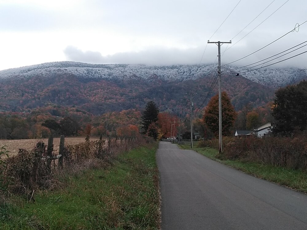
Clinch/Beartown Mountain this morning.
-
5
-
-
The high for tuesday was shortly after midnight at 38.4 while falling to the low 30s by morning. During the early evening I managed to crack 37 before falling back to 36 and staying there til now. I noticed some flurries flying this morning but didn't experience any accumulation. If Big A or Clinch mountain saw anything I may take a picture or two in the morning with things cleared out.
-
2
-
-
The recorded low this morning was 29.4. This marks my first frost, bout right on schedule. Things warmed up pretty nicely though into the 60s this afternoon.
-
2
-
-
If I'm not mistaken cool and dry conditions once in October are considered ideal for fall foliage. Display wise we may all be in for a treat. So long as those reds oranges and yellows aren't flames.
-
2
-
-
It's looking like Octobers debut this year is going to feature a high in the 40s. Wowza. Winds were negligible beyond a moderate breeze. My digital rain gauge is unreliable though I can say the total has been modest, ~1.25" or so. Hopefully that should suffice for the next two dry (?) weeks ahead. I gotta say, I wish Ian tracked further west for the rest of y'all.
-
1
-
-
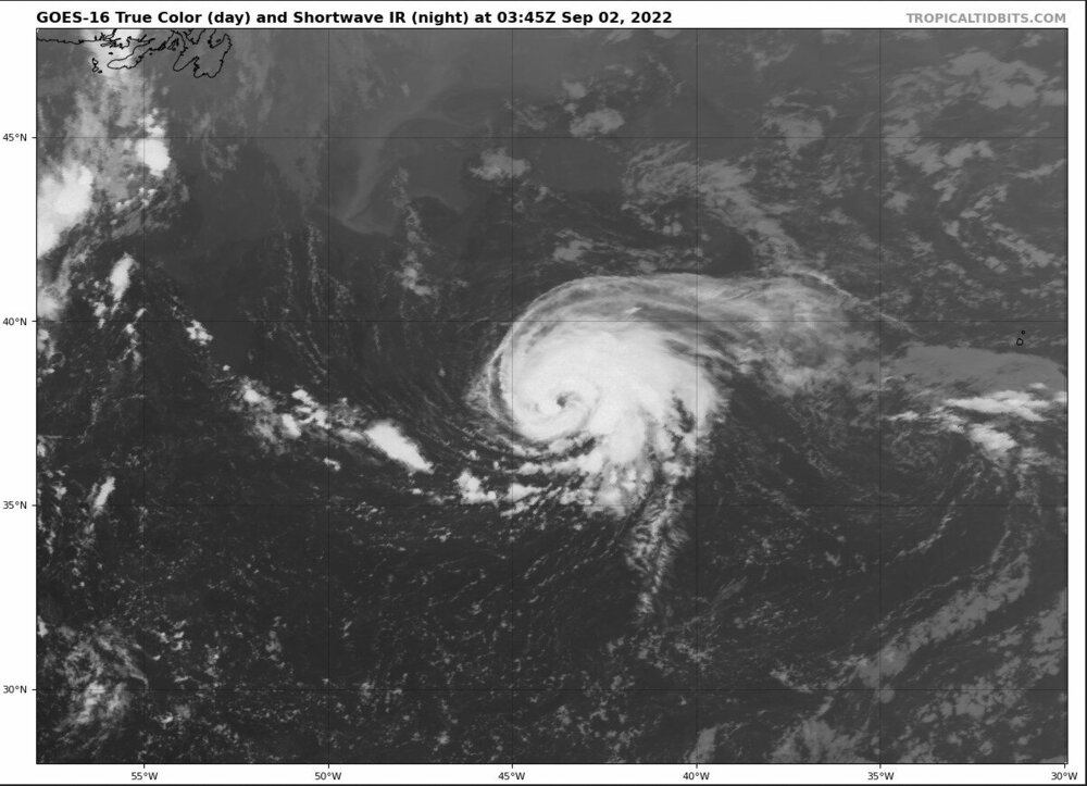
Is there any appreciable possibility of partial regeneration in the southern half of the storm? Or will interaction with the cold front/dry air/mid-lat shear dash that?
-
She's looking snazzy tonight.
-
2
-
-
It got to a point up my way I gave up on the mower and pulled out the old weed-eater. Of course mid-way through knocking things back down to something resembling a yard a thunderstorm put an end to that and likely will today. I must say though I have been appreciating the moderated temperatures.
-
2
-
-
Good disco by MRX this morning.

X000 FXUS64 KMRX 280744 AFDMRX
AREA FORECAST DISCUSSION
National Weather Service Morristown TN
344 AM EDT Thu Jul 28 2022
.SHORT TERM...(Today and Tonight)...
Key Messages:
1. Flash Flooding threat for our southwest VA counties through late
morning/early afternoon, Flood Watch in place through 18Z.
2. Conditional Flash Flood threat this afternoon, once again, mainly
along and north of I-40.
3. Isolated damaging wind gusts possible with any stronger storm
this afternoon.

Discussion:
Now through sunrise:
Periods of showers and storms will move across southwest VA
through at least late morning according to the last few runs of
the HRRR. Periods of moderate to heavy rain are expected. Current
1 hr FFG values across our SWVA counties ranges from 0.75 to 1.25"
with 3 hr FFG values from 1 to 2". The ongoing and additional
rainfall that is expected will likely cause localized flash
flooding, depending on where the heaviest rainfall occurs. For
this reason, went ahead and issued a Flood Watch for Flash
flooding through 18Z for our SWVA counties. The HRRR has also
shown additional showers and storms developing along the KY/TN
border, also through late morning. Radar returns are beginning to
increase across these areas, confirming what the HRRR has been
showing. This will also be an area to watch for potential isolated
flash flooding but not confident enough to include these areas
within a Flood Watch at this time. Will continue to monitor things
closely.

The rest of the day:
The forecast over the past few days has been very frustrating to
say the least. As mentioned in previous discussions, it`s very
difficult to pinpoint where convection will be focused in a weakly
forced environment. The good news, we`ve missed out on the heaviest
rainfall over the past few days as it has largely remained to our
north. The bad news, FFG values still remain very low for areas
north of I-40, especially across southwest VA. The environment for
today remains unchanged with a frontal boundary to our north and
high PWs still in place, so moderate to heavy rainfall is still
expected with any convection that develops. As of now, the CAMs seem
to show a little better coverage of showers and storms across our
area through the day compared to previous days but we will see
how that goes. As with the past few days, an isolated flash
flooding threat still exists for today but is conditional on the
amount of shower/storm coverage we see. In addition to the flood
threat, we will also see a threat of isolated damaging wind gusts
with any stronger storms if they develop, mainly during the
afternoon hours.
POPs will continue into the overnight hours as a weak shortwave
impulse moves through the upper trough, keeping isolated to
scattered showers and storms going through the night. Highest POPs
will be across far northern areas. Patchy fog likely overnight
across areas that see rainfall through the day today.

.LONG TERM...(Friday through Wednesday)...
Key Messages:
1. Unsettled pattern through the extended period with high rain
chances through about Monday.
2. Locally heavy rainfall and flooding possible through the weekend.
3. Ridging aloft begins to build back over the region Tuesday with
more diurnally driven convection.
Discussion:
On Friday, a frontal boundary will be lying across central Kentucky
and western Tennessee early in the day and then shift south to the
southern areas of east Tennessee by evening. High precipitable water
values and CAPE values up to around 2000 J/KG during the afternoon
could cause some strong winds with the storms Friday and possibly
Saturday and Sunday if there is enough heating.

Showers and thunderstorms will continue to develop and move across
the northern parts of the CWA early in the day Friday. Highest
rainfall totals for the forecast area for the first day of the
extended forecast look to be over the same area as Thursday and a
second area over the southern Valley. The front is forecast to shift
farther south during the day Friday with heavy rainfall shifting
southward out of the northern area. Then Saturday more shortwaves
will move from west to east along the front and affect much of east
Tennessee with heavy rainfall.Sunday the front seems to lift north
again with heavier rainfall across the northern sections. The broad
troughing over the eastern states deepens Monday night and Tuesday
with Ridging aloft building in from the central states back into the
Tennessee Valley. Convection will then become more diurnally driven
Tuesday and especially Wednesday and fast moving shortwaves will
only bring light amounts of rainfall to the region. The showers and
storms will be more typical afternoon and evening convection
triggered by heating. High temperatures will stay mostly below
normal...in the 80s through the period.
TD
.AVIATION...
06Z TAF DISCUSSION.
CHA and TYS will be VFR through the period, other PROB30 MVFR for
afternoon storms. Showers and storms are currently just north of
TRI across southwest VA. A few showers may move across TRI through
sunrise, resulting in MVFR conditions. Then, VFR conditions
through the rest of period except for PROB30 MVFR for late
morning/early afternoon storms. Winds will generally be 10 kts or
less from the southwest at all sites.

.PRELIMINARY POINT TEMPS/POPS...
Chattanooga Airport, TN             92  74  90  73  88 /  50  40  80  50  70
Knoxville McGhee Tyson Airport, TN  90  73  86  71  85 /  70  40  80  60  70
Oak Ridge, TN                       89  72  85  71  84 /  70  50  80  60  60
Tri Cities Airport, TN              86  70  83  68  82 /  60  40  80  50  60
.MRX WATCHES/WARNINGS/ADVISORIES...
NC...NONE.
TN...NONE.
VA...Flood Watch until 2 PM EDT this afternoon for Lee-Russell-Scott
     VA-Washington VA-Wise.
-
The snow showers are making it into the valley from the plateau up this way. Making for a pretty morning all considered. Yesterday while in Abingdon I experienced a first. In the late afternoon some dime size hail was followed by some bursting snow say 20 minutes later. Temps were in the upper 40s and dropped to the mid 40s. My only guess is a strong downdraft associated with the storm allowed the flakes to reach ground altitude as much of a stretch as it was. Really ties in with the crazy wind we've been getting.
-
2
-
-
Thought this was worth sharing. Pretty neat.
-
5
-
1
-
-
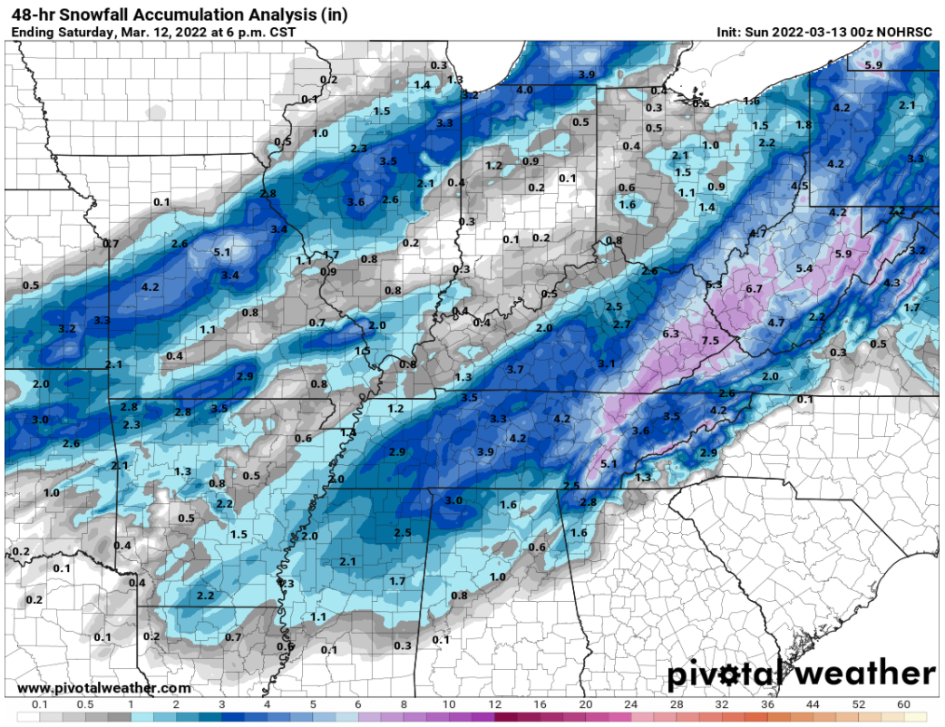
2 hours ago, John1122 said:
Snowfall Map from yesterday and then today regarding this system. They cover the same timeframe. I don't know how the map changes this much for the same time period 24 hours later. The sad thing is that both are wrong, but the updated one is even more wrong. Things like this is why the significant winter storm snowfall maps end up looking way off years later and why the snowfall record doesn't line up with our memories and observations.
The updated map has Scott County with nothing to a dusting. They had 6-8 inches. It has snow totals in my area at 50% of what actually fell. Among my friends at various parts of the county there was 10 near the Claiborne line, 8 in Jellico, 8 in Jacksboro, 10 in LaFollette, 8 in Caryville.
You guys can decide if either lined up for your area. The first map was close here.
Map from yesterday.
Map from today.
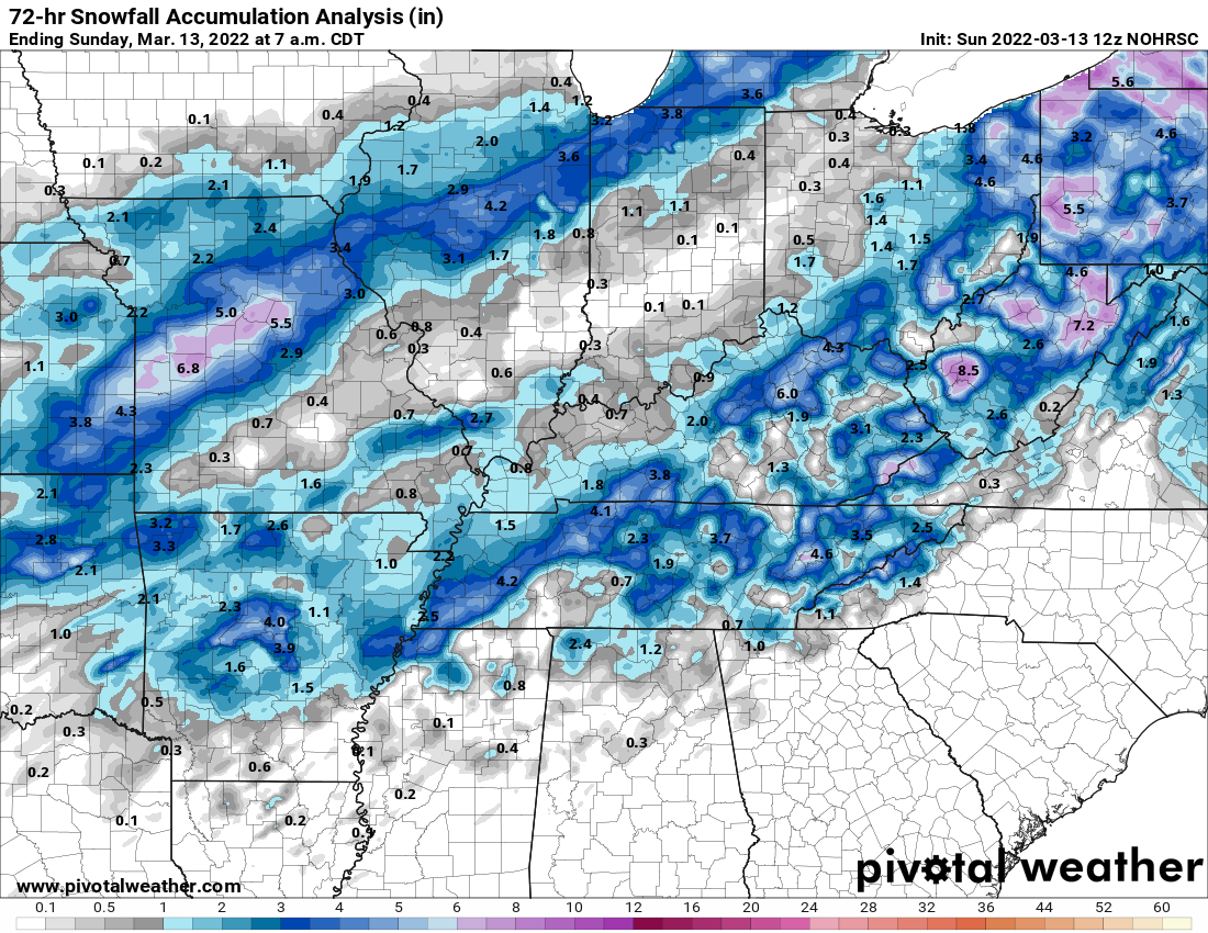
With the exception of Clintwood I would argue all of swva is off broadly speaking. Especially for the 2nd depiction. The storm reports are a testament to that much. https://www.spc.noaa.gov/exper/reports/?&all&date=20220312
-
2
-
-
Got a low of approximately 6.8 here. Second coldest night of the year unless december has something to say about it.
-
1
-
-
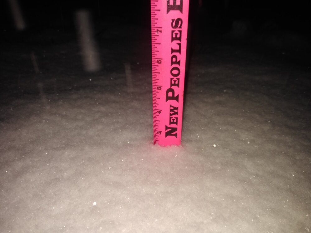
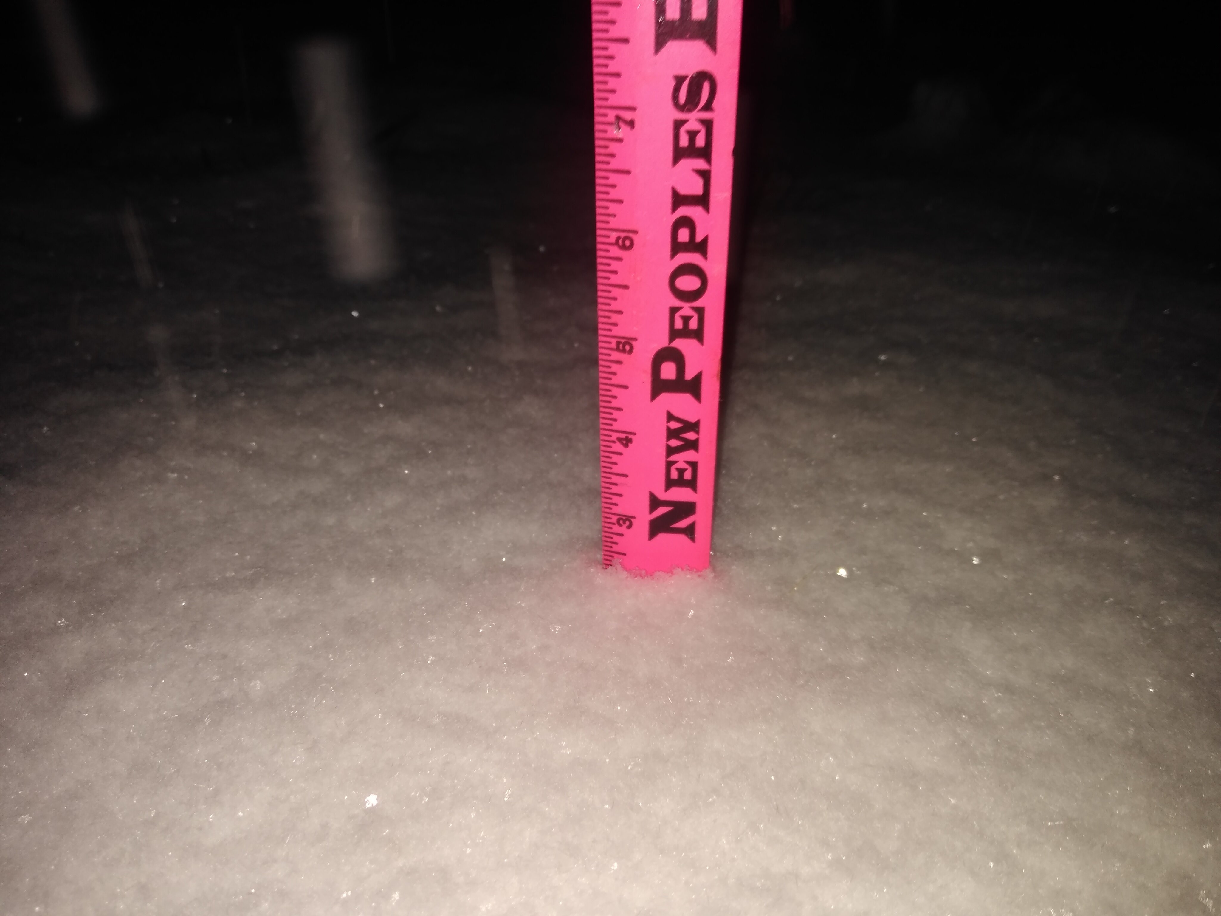
Weighing in at an average of 6 inches in the yard maybe 6.5 on the tile I measure on. Wow! And still more to go!

-
8
-
-
It's a rare but welcome sight for a weather weenies tired eyes. At last in the dead of night, it has arrived. You had about written the season off but a week or two prior. You looked under a skeptical lense as a potential storm presented itself mere days prior. Surely the models had one too many... Now at last you look out your window to what appears a winter wonderland in the 11th hour. You then look to the radar only to see a solid ocean of deep blue and can't help but grin. "Finally!"

-
8
-
-
Getting into the meat and potatoes of the winter storm now. With 2" on the ground the fat flakes have been replaced with a steady stream of fine flakes like those stovepipe mentioned earlier. The main road has cleared though I don't suspect it will remain that way with some of the heavier bands coming up the valley. Currently on track for the biggest snowfall of the season barring a dry slot.
-
2
-


Historic Christmas Cold & maybe snow?! Dec 23rd-30th
in Tennessee Valley
Posted
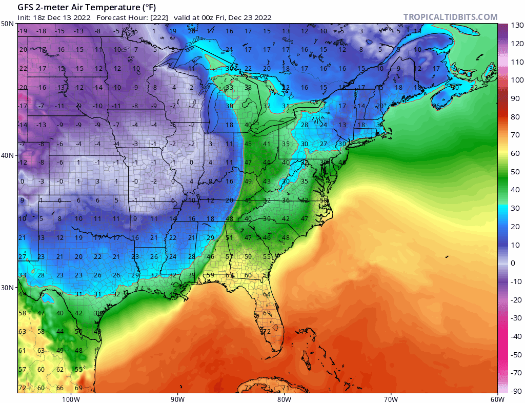
@fountainguy97Just adding to what you said,
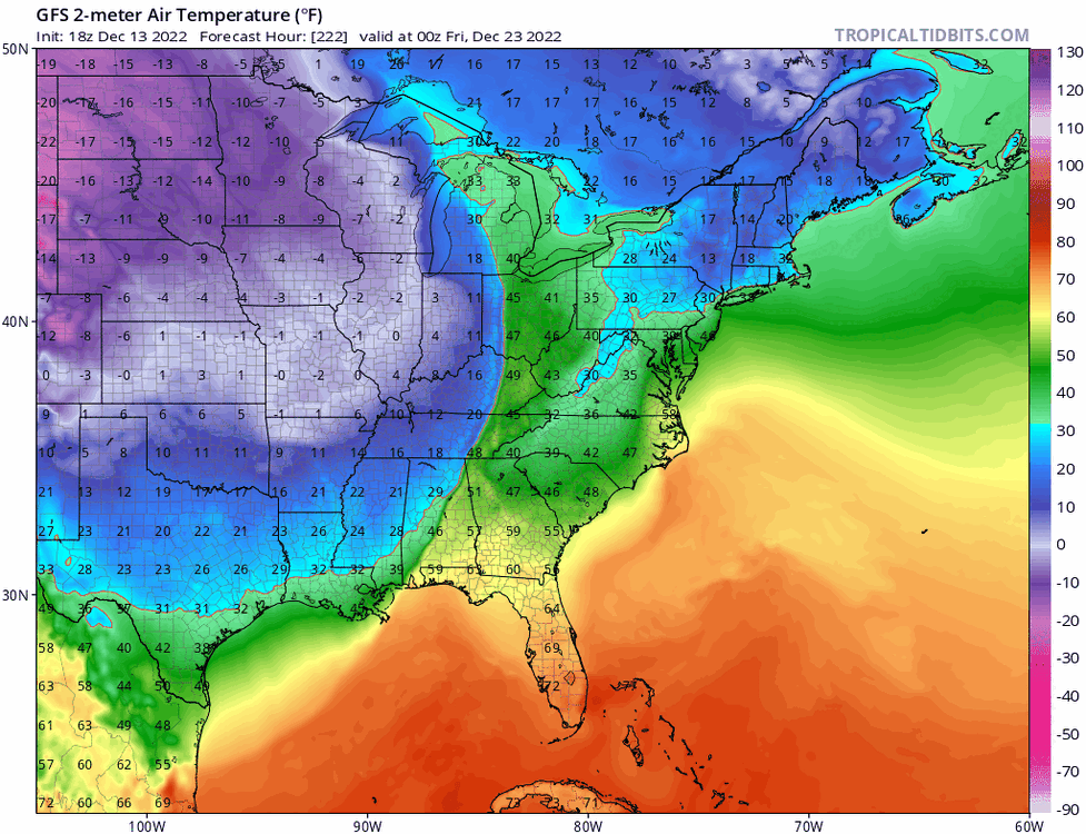
18z GFS for 1 AM Friday juxtaposed with the 12z EURO's front placement (difference highlighted) and negative tilt (in dotted yellow). Some of the difference is in the speed of progression but some of it is indeed the cold hitting harder overrunning the precip.
As an aside interestingly the Euro has Iowa roughly 10F colder at the same hour.