

BlunderStorm
-
Posts
1,121 -
Joined
-
Last visited
Content Type
Profiles
Blogs
Forums
American Weather
Media Demo
Store
Gallery
Posts posted by BlunderStorm
-
-
Now 35 and mixing. No sleet in the mix from what I can see. Clean transition. Here we go.
-
 2
2
-
-
The rain is now falling in the far east and the temps are about to collapse. Winds getting into the teens and currently 43.
-
2
-
-
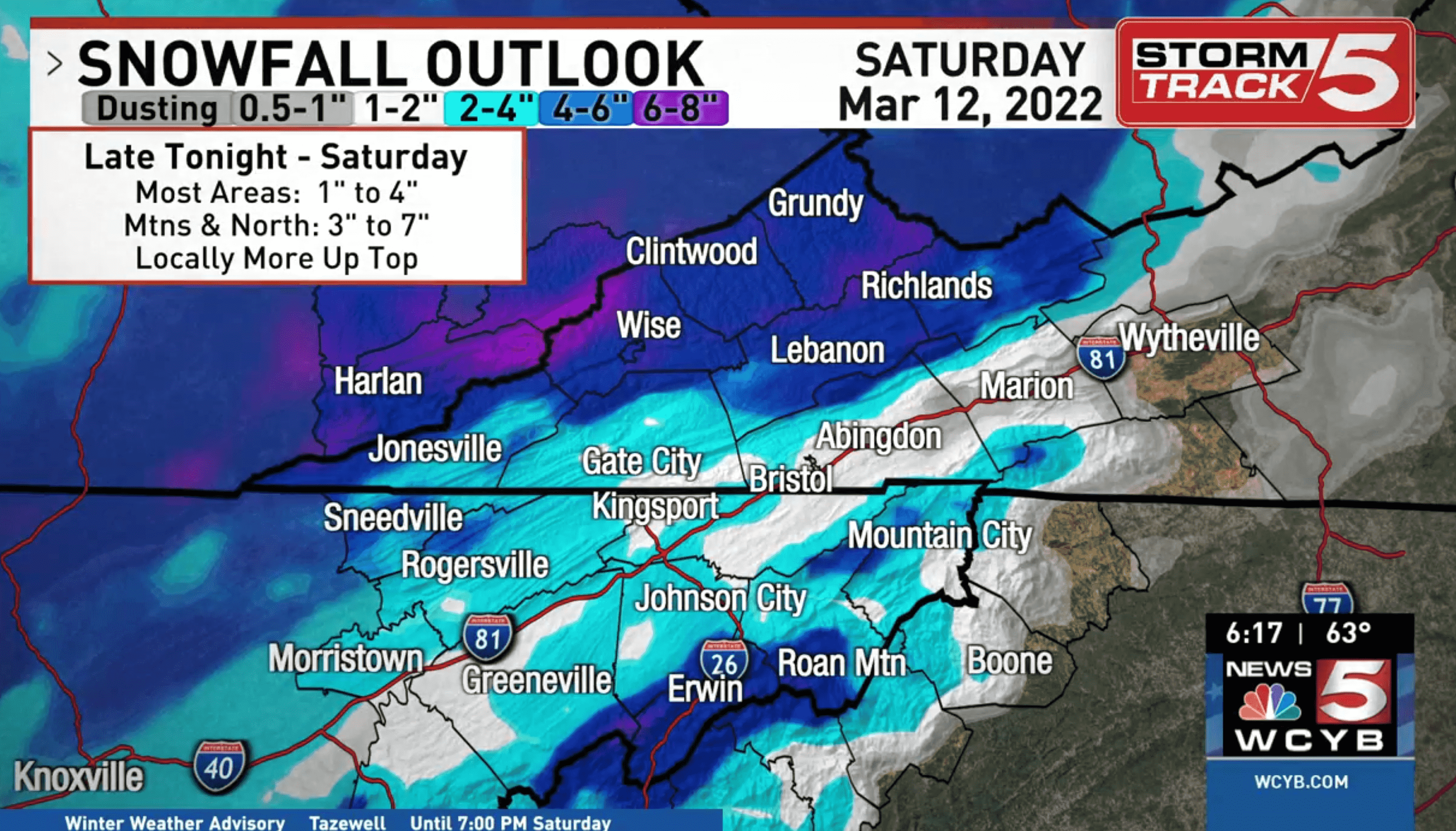
For reference, here's the prediction from WCYB.

-
2
-
 1
1
-
-
1 minute ago, Reb said:
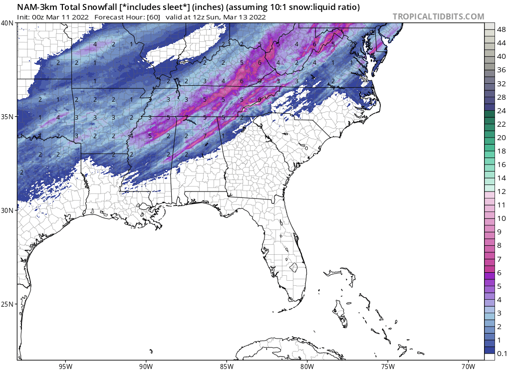
3km 00z NAM was actually pretty nice

Definitely a step up for far eastern and western TN. Plateau loses some but is still smacked. Not bad at all.
-
5 hours ago, Silas Lang said:
Oh sorry, there was a little more for the far East. Goodness.
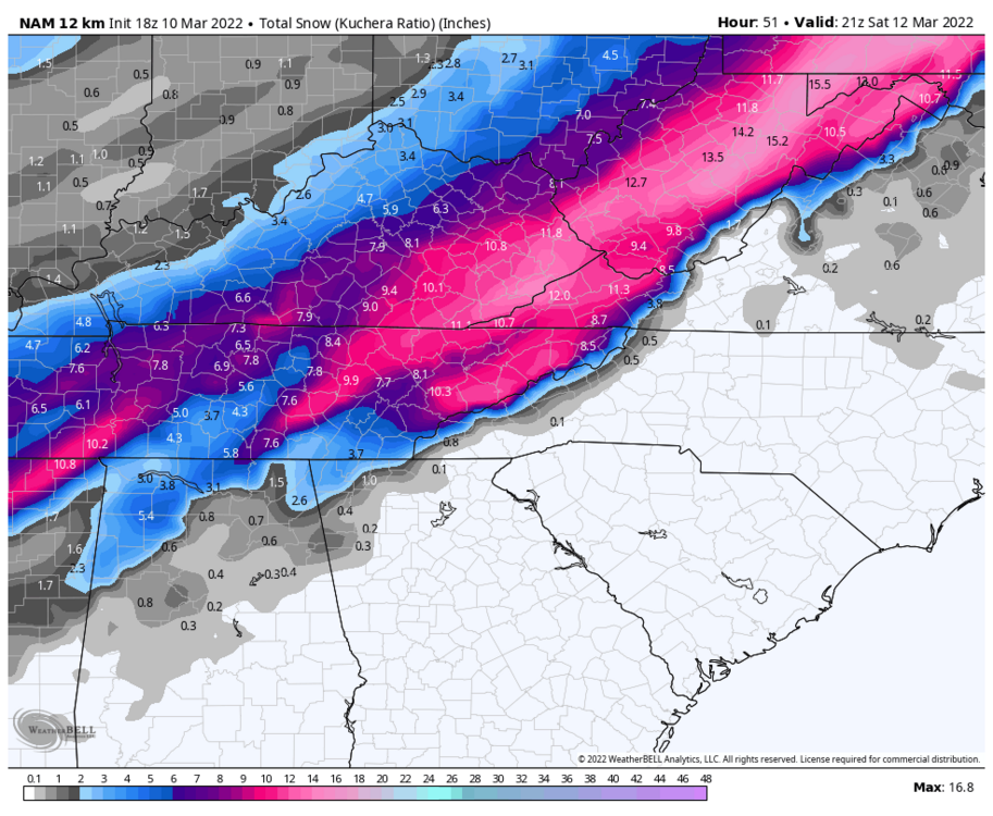
Bit of a late response but... Well let's see how 0z holds up. I'm hoping the 3km fills the ETN "snowhole" but really even that much would be a nice close to the season.
-
1
-
-
19 minutes ago, John1122 said:
I believe that sometimes just being further north helps. Jamestown/Oneida and my area are about the same latitude and similar in Elevation. I know that 1200 feet in Campbell County gets more snow than 1200 feet in Knox County as a rule and 1200 feet in S Kentucky gets more than 1200 in Campbell.
Relative elevation as well as the orientation of the mountains also plays a major role. While I may be roughly 350' higher and at the 37th parallel, living in a river valley puts my annual snowfall totals beneath yours consistently.
-
3
-
 1
1
-
-
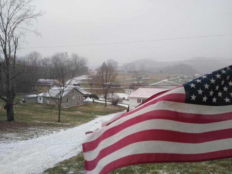
I know I was forecast for more than a dusting up this way but I was too cynical and underestimated it. After the initial virga and marginal temps things have really materialized in the past 2 hours with an inch of snow already accumulating and the median of the road whitening. Radar in general has improved leaps and bounds from 6 hours ago for the backend of this system.
-
2
-
-
No comment.
-
1
-
3
-
 1
1
-
-
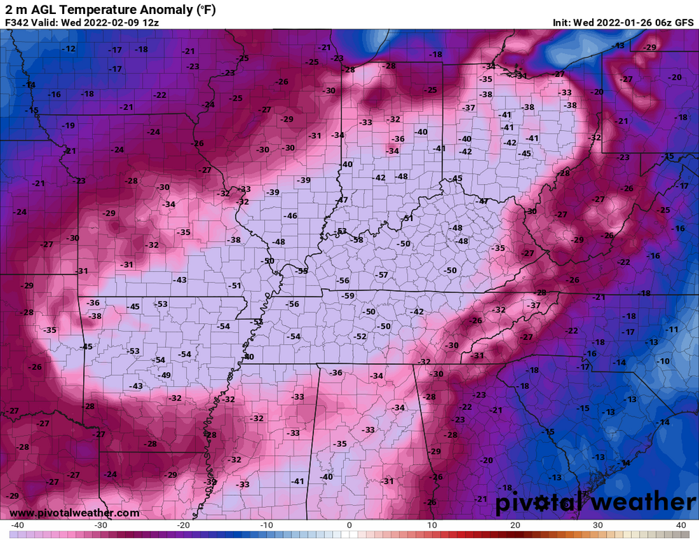
06z GFS Has possibly the coldest air of the entire winter following a vicious App cutter next weekend could be a good deal plateau and west. The associated trough is a lot less positive. Canadian seems to be on board as well but will see if it continues the trend later this morning. 0z Euro was too west for everyone.
(9/10 days out take with a grain of salt)
24hr Kuchera https://www.pivotalweather.com/model.php?m=gfs&p=snku_024h&rh=2022012606&fh=210&r=us_ov&dpdt=&mc=
2m Temps https://www.pivotalweather.com/model.php?m=gfs&p=sfct&rh=2022012606&fh=246&r=us_ov&dpdt=&mc=Edit: Holy #### Check out the GFS clown in the 300 range. Practically forms a "Tenntucky" Ice Sheet.

-
1
-
-
Just now, Tucker1027 said:

."I didn't hear no bell!"
-
2
-
2
-
-
1 hour ago, BuCoVaWx said:
I don't think I'm going to end up with anything. Mixed earlier, now I've been in dry slot for over 4 hours. Radar isn't looking good either, keeps pushing away. Oh well, can't win them all. Glad some of you guys are cashing in though, gives me hope for the future
") 2 hours ago, BuCoVaWx said:
2 hours ago, BuCoVaWx said:Not a thing here in Grundy. Freezing rain hours ago, it's been dry ever since.
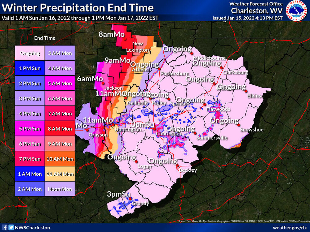
You're not alone. When the dry slot hit temps went from 26 to 38 and have only been dropping in the past couple hours. Only the back end can save us from a complete bust. As of now the pivot is in full gear. Here's hoping...
-
2
-
-
25 and heavy snow and sleet. Maybe the coldest I remember sleet falling. The main road is white. About 1/3 an inch of frozen stuff on the ground.
-
5
-
1
-
-
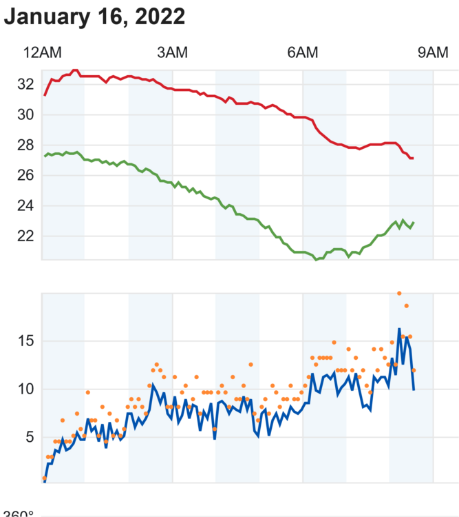
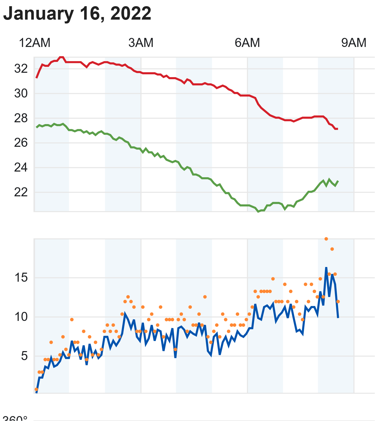
About 1/10th an inch of sleet has accumulated. Temperatures as of 8:30 stand at 27 and remain stable. Up until now winds were steadily increasing but I think this trend may be thankfully ending. I think I'll take the dry slot over an ice skating rink.
-
Precip rate has lowered and the sleet is beginning to more closely resemble graupel (sorta). Overall it looks like Clinch mountain is up to its old downslope tricks for my microclimate. The 850 level must be a mess. Lol, I'll never forget how much of a bust I got from a nearly identical setup on radar back in December 2018. I was so pissed I screenshot an Intellicast radar frame and made this little piece of "art" in MS paint.
 In retrospect not my finest moment. This time it was to be expected. Anyway, how are things goin on the plateau and west is the snow holding?

-
1
-
2
-
 1
1
-
-
27.6 and within the last 10 minutes precip finally started reaching the ground. Currently 100% Sleet. Curious how long this set-up holds.
-
3
-
-
Hours outta play up yonder but 32/27. Not hourglass shape but I'll take it with a smile. The real battle is above our heads.
-
-
1 hour ago, TellicoWx said:
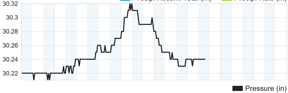
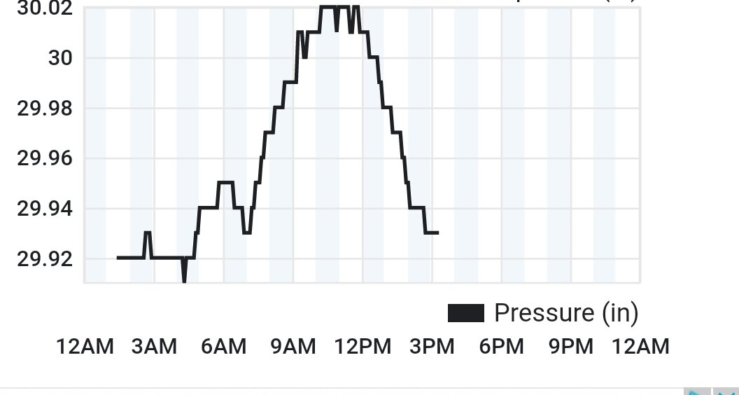
Not sure if this has any effect what so ever, but alot of the Hires models ingest data from PWS networks and other real time data. Thus is from my PWS, recording the pressure wave from the Tonga explosion, would have been around time 12z to 18z data was being ingested.
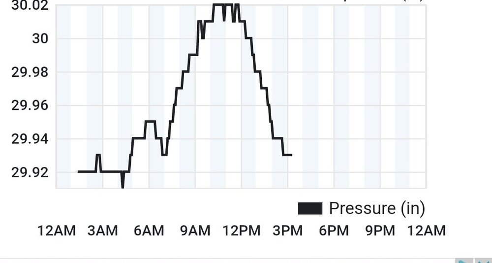
Neat! Just thought I would add my own pressure reading.
-
1
-
-
Anyone know if those super early radar returns south of Crossville are the real deal? On another note looks like the low is about 50 miles due east of Texarkana as of now.
-
4 minutes ago, Windspeed said:
Usually I feel pretty good for KTRI versus the rest of the eastern Valley, even with an annoying 850 nose. But I honestly have no idea what to expect with this one. Obviously we're in a better location than areas southwest for MRX (Knoxville, Maryville, down to Chattanooga., etc.), if we can get rates to pump and negate that sloppy downslope potential. This system has a small chance to overperform for the eastern Valley like '96 if that 850 slows and digs further south than modeled. But it could also just not overcome the nose at all. So, again, I have no idea on this one. Uncomfortable to make a call. Too much sour modeling to get excited myself. I will say if we squeeze out anything more than 3+", it's a win.
SWVA folks might be able to hold on to the upper levels but I doubt it with current guidance especially south of the state line. Our best chance is on the back end with the TROWAL. Even then it's a pyrrhic victory for the far east of the sub forum leaving the plateau and west outta the picture. As it stands nothing in the tri-cities looks right. If I get 2" up my way I'm happy and if I get 4+ I'm ecstatic.
-
9 minutes ago, Vol4Life said:
I don’t have access to the RGEM. Do you have an accumulation map for it? Did it stay with a Miller A look?
The "RDPS" on Pivotal is the RGEM. I didn't know for a long while too. https://www.pivotalweather.com/model.php?m=rdps&p=snku_acc&rh=2022011418&fh=78&r=us_ov&dpdt=&mc=
-
1
-
-
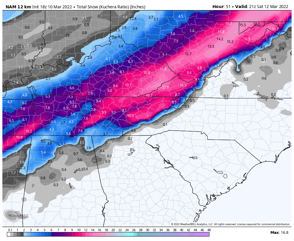
18z NAM 3km at 48 hours... How on Earth you screw up the upper air that much I don't know.


-
1
-
4
-
-
The extreme E to W downslope over the spine of the Apps with the latest run of the NAM and to a lesser extent the GFS reminds me of the Jan 2016 Blizzard. Though in the case of that the low transitioned to the coast by Charleston rather than running up to swva then shifting to the Outer banks.
-
17 minutes ago, TellicoWx said:

Oof. but hey, the mid-state really cashes in.


-
1
-


March 11th-13th Winter Weather Event. Winter's last gasp?
in Tennessee Valley
Posted
Getting huge puddles of silver dollar sized crystalline water.