
BlunderStorm
-
Posts
1,171 -
Joined
-
Last visited
Content Type
Profiles
Blogs
Forums
American Weather
Media Demo
Store
Gallery
Posts posted by BlunderStorm
-
-
This morning the North Fork of the Holston was frozen over hwy 19. So was the Clinch in Honaker. (sort of) actually there were still some small open spots on both rivers among larger swathes where it was froze straight across but still!
-
 3
3
-
-
Inexplicably I'm holding the line at 31.5. Air is dry with a dp of 11. Seems warmer in every direction on wunderground. The skies are a solid wall of grey. There's certainly juice up there and probably warm air aloft to boot. This may not be pretty. I'd welcome the virga if it could cool the column for pure snow.
-
3
-
-
25 minutes ago, PowellVolz said:
We have a winner?

.How the- wow! Just down the road.
-
2
-
-
Finally beginning to wrap up. Here's a slow mo of the final wave a few moments ago.
-
3
-
-
John may have released the trailer for the cash grab sequel snowstorm but this one has a heck of a post credits scene. No clue when it will finally end lol.


-
5
-
-
Today was a nearly perfect 24 hours of snowfall. While lacking in some of the stronger bursts seen further south it made up for it with consistency. At no point was mixing an issue. As of midnight I officially report 6.2 inches for the day. An extra inch overnight wouldn't surprise me. It's been fun.

-
2
-
-
25 with light snow persisting under the radar. 6+ inches have fell.


-
9
-
-
-
The hammer is coming down now! Snowfall rates have reduced visibility to nearly half a mile. The road is covered and temps are maxxed for today at 29. Approaching 5 inches shortly!


-
7
-
-
Sitting at 3 inches and climbing. I may be behind but I'm also late! Rates are consistently moderate with visibility of a mile. Temps rose again but are starting to plateau at 29.
-
13 minutes ago, PowellVolz said:
Actually that might not be good for them. That could be, likely bright banding. When snow is in the process of melting on the way down it expands, gets bigger. When it gets bigger it shows up on radar as extremely heavy precipitation. I’ve been under those before and it could be light rain switching back and forth to fat mush flakes.
.A possible example of this can be seen right now in Florence, Alabama. Radar is showing heavy snow returns over there but the webcam shows a mix of precip types.
https://florenceharbor.com/index.php/350-2/-
1
-
-

Temperatures have leveled off a tick above 27F. This corresponded with an increase in snowfall rates and shift in wind direction. Snow trucks rolling and scraping nonstop now!
-
1
-
-
Johnson City ETSU campus cam showing snow. wonder if the rain in southern Greeneville and Erwin creep up to it. Gotta head over there on wednesday haha.
-
3
-
-
3 minutes ago, Uncle Nasty said:
It's been puking in Ooltewah for a little while now. It looks like the rain snow line is a hair to our south. Is it possible for us to stay all snow in the transition zone and overperform?
I k ow it's a computer generated forecast, but TWC took us from 1-3" to 5-8" right after the moderate snow started.
I'll take half that amount and call it a day down here!
Sent from my SM-S916U using Tapatalk
6 minutes ago, Hurricaneguy said:Just switched to rain/sleet here in Greeneville. Not looking good now. Pain if this busts here.
19 minutes ago, ShawnEastTN said:My road which is a secondary state highway was brined yesterday, scraped and salted by TDOT at 730 this morning.
 10 minutes ago, RawCrabMeat said:
Some sort of sleet/rain in Maryville. Looks like a total bust here unless it can somehow change back over. Was only snow a couple hours ago. I’ll have to find something else to do today.
anybody know if there’s a chance of switching back to snow in Blount?
-
3
-
 3
3
-
-
9 minutes ago, tnweathernut said:
You guys getting a good snow need to get better at taking pictures and sharing with us.... Just a casual observation. lol

-
8
-
-
2 minutes ago, WinterWonderland said:
Is there a way to tell where posters live? I check their profile but don't see a location. Folks are posting their current weather conditions and it would be good to know the location they're talking about.
Everyone be safe and enjoy the snow!
Sent from my Pixel 3 using Tapatalk
So, in order to see locations you'll need to open the desktop version of the site. (Avoid using tapatalk) You can do this fairly easily by opening your settings on your phones web browser. An extra perk of the desktop version is you can see profile signatures.
-
1
-
-
After the snow started I grabbed some Zs. Usually I don't like to miss any moment of a snowstorm. Tonight feels special though, with over 24 hours of duration and secure temps I felt relaxed. I enjoy the rush of attempting to predict what systems will do and yet, this was nice. Waking up to a field of white and knowing you don't have school/some other responsibilities... I still woke up early like a man possessed but I think I'm at peace for now. Anyway I haven't taken measurements yet but there is a solid inch plus of powder. Temperatures have seemingly leveled at 23. Light snowfall currently.

To those commuting today yall be safe, and hopefully yall in the southern great valley can overcome mixing trouble.
-
8
-
-
First flakes ten til midnight. Here we go!


-
8
-
-
Update: It's now 26.5 with a dp of 20.3. The low level atmosphere is primed here for a classic southern Appalachian snowstorm. Won't be long now... I hope.
-
7
-
-
Still at least 6 hours out. 27 in Honaker with a dewpoint of 18.
-
8
-
-
RAP significantly upped totals for 21z across the board. Also kept Chatty in the game.
")

-
1
-
 1
1
-
-
34 minutes ago, PowellVolz said:
Soak it up fellas
Tip of the WSW spear baby let's seal the deal!
-
2
-
-
24 minutes ago, Carvers Gap said:
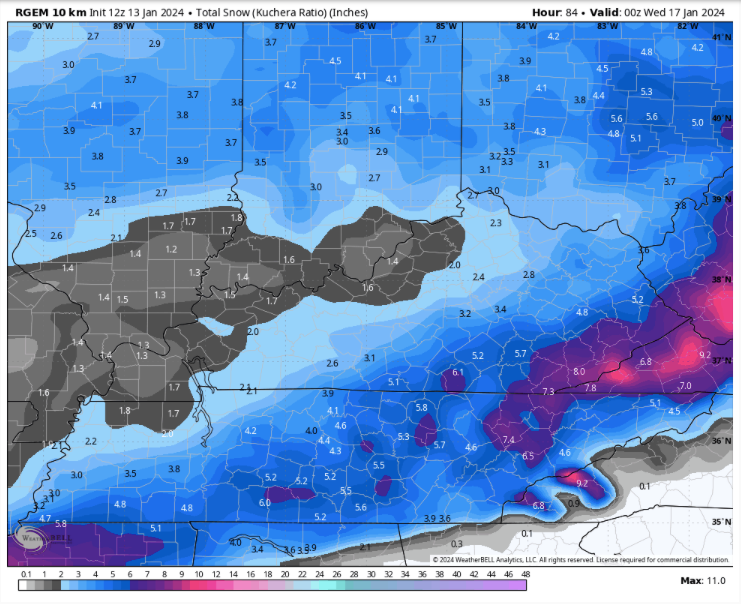
It's been a long time since something like that happened here. Most I've ever recorded in a day since recording totals in late 2016 was March 22' at 6.7". I'd take a quarter of that snow total haha. One of the concerning aspects of that run however was the presence of the warm nose/downslope (not sure what that chalks up as). Pivotal shows a significant stretch of zr resolving the 12z rgem expanding on what ice the 6z had. Areas in the eastern edge of the valley most effected but I can't help but wonder if something similar could be seen to the nw of Bays mountain and Clinch mountain. Also hi everybody!
-
1
-
-
On 12/30/2023 at 1:24 PM, BuCoVaWx said:
I'm about 20-30 miles west of @BlunderStorm, but I remember as recently as 2018 (if I'm not mistaken) Abingdon received nearly a foot of snow, possibly more. We ended up with a cold rain. Very wild how things can differ in such short distances.
I may or may not recall that one, but I will say Clinch/Beartown mountain influences a lot of the weather. Also Big A to a lesser extent in the Honaker area. Downsloping can easily kill an otherwise excellent set-up. All the same it can trap colder air in the upper Clinch valley and I can cash in.
-
1
-

February 2024 mid/ long range
in Tennessee Valley
Posted
Welcome aboard!