STILL N OF PIKE
-
Posts
14,848 -
Joined
-
Last visited
Content Type
Profiles
Blogs
Forums
American Weather
Media Demo
Store
Gallery
Everything posted by STILL N OF PIKE
-
Preliminarily ... a medium impact partial Miller B, Friday
STILL N OF PIKE replied to Typhoon Tip's topic in New England
Gfs full on weenie run for storm and extends it for ray and pope w Saturday fun. Not gonna happen but nice to see lol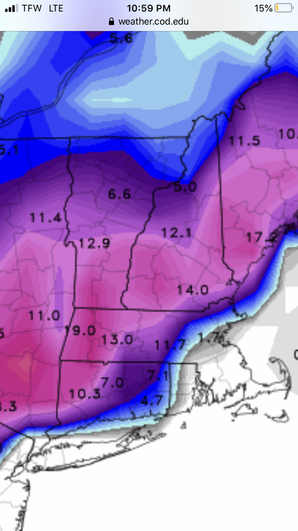
-
Squalls moving south in NH and Maine and parts of VT
-
Preliminarily ... a medium impact partial Miller B, Friday
STILL N OF PIKE replied to Typhoon Tip's topic in New England
I think that front end thump still holds most of the promise for those in CT outside NW hills . If rates are there , could see a surprise even at lower elevations off the S coast -
Preliminarily ... a medium impact partial Miller B, Friday
STILL N OF PIKE replied to Typhoon Tip's topic in New England
Nam track about same as 18z euro now and 925 a shade cooler than euro
-
Preliminarily ... a medium impact partial Miller B, Friday
STILL N OF PIKE replied to Typhoon Tip's topic in New England
0z nam out to 6hr , looks East -
Preliminarily ... a medium impact partial Miller B, Friday
STILL N OF PIKE replied to Typhoon Tip's topic in New England
Meh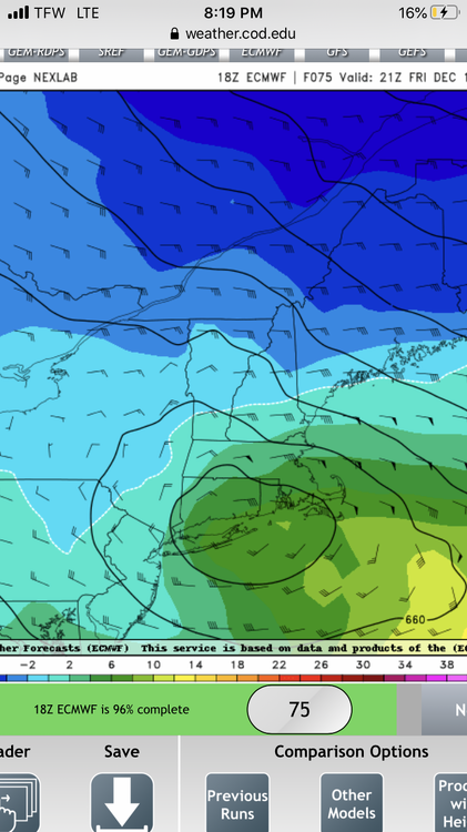
-
Preliminarily ... a medium impact partial Miller B, Friday
STILL N OF PIKE replied to Typhoon Tip's topic in New England
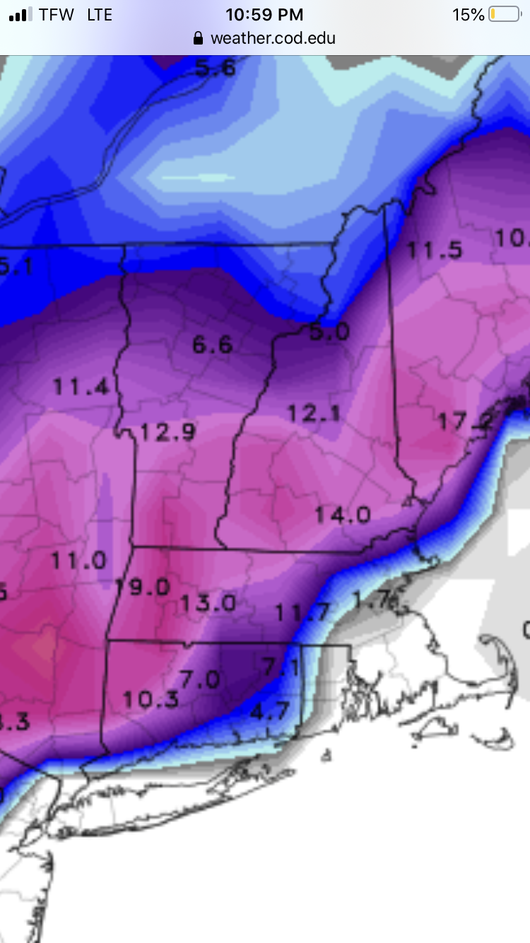
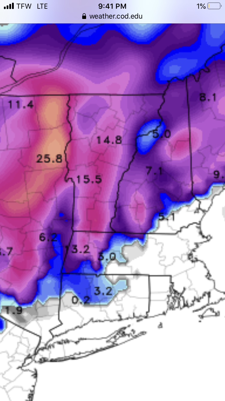
The snowpack in northern Vermont is 1-2 inches currently . If this tracks just off the coast it will cost N VT synoptic snow and upslope . But ya Someone on I-89 in monads or VT will probably have 8” Along the ride if northern areas don’t make out -
Preliminarily ... a medium impact partial Miller B, Friday
STILL N OF PIKE replied to Typhoon Tip's topic in New England
where do folks go for off hour euro runs that are out fast -
Preliminarily ... a medium impact partial Miller B, Friday
STILL N OF PIKE replied to Typhoon Tip's topic in New England
Don’t forget the Navgem lol -
And when you average 40-60 like most in SNE , prepare on not getting laid after dinner , unless she’s drunk and pantsless (inside 4 days modeled snow storm) and If the stars line up and you do , don’t imagine seeing her “O” face but couple times a season
-
Preliminarily ... a medium impact partial Miller B, Friday
STILL N OF PIKE replied to Typhoon Tip's topic in New England
NW CT could -
Preliminarily ... a medium impact partial Miller B, Friday
STILL N OF PIKE replied to Typhoon Tip's topic in New England
Shows less precip in central -nne and better for WOR in CT and that I need to change my phone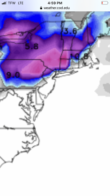
-
Preliminarily ... a medium impact partial Miller B, Friday
STILL N OF PIKE replied to Typhoon Tip's topic in New England
Where are you located , I see areas in NW CT , HFD , Berks and S NH the same temp as the precip starts hours 54-60 over W SNE as 12k nam nam gives a good thump of mashed taters -
Preliminarily ... a medium impact partial Miller B, Friday
STILL N OF PIKE replied to Typhoon Tip's topic in New England
I think if your WOR and not in the Berks or Norfolk county you want to route for a robust front end thump like nam is showing . Starts it early as well just after midnite WOR. -
The easiest way to cause an uproar is to mention cutter , leads to meltdowns , and Witch trials for some weenies . There should be a re education camp for folks ..like they have in western areas of China Till the word cutter is banished from their vocabulary . In all seriousness , many of us met each other , it is funny - all parts of most discussions here Its gonna be a fun 15 days leading into the holidays hopefully the WOR folks can cash in on a front end thump like 18z nam shows
-
Is the second one the mai-tai look with police below Area bridges And children crying as PF dangles from the quad lift
-
Euro op is basically what I was talking about and what I believe Scott mentioned as a risk to the good LR pattern actually happening the Rockies trough moving west and then it also deepened which boosted SE ridge . It hasn’t happened and 12z eps isn’t out but it is a risk at day 8.5 + . It’s not some slam dunk look with lots of wiggle room in either side
-
Preliminarily ... a medium impact partial Miller B, Friday
STILL N OF PIKE replied to Typhoon Tip's topic in New England
I mean if 8-12 at 1-2k sucks ,I’ll take it -
Preliminarily ... a medium impact partial Miller B, Friday
STILL N OF PIKE replied to Typhoon Tip's topic in New England
We just need the nam to lead the way -
Preliminarily ... a medium impact partial Miller B, Friday
STILL N OF PIKE replied to Typhoon Tip's topic in New England
How many days we been tracking this ...9? Originally it may have been a Wednesday pm cold front with torching heavy rains ahead of it -
Preliminarily ... a medium impact partial Miller B, Friday
STILL N OF PIKE replied to Typhoon Tip's topic in New England
Nice write up . -
Preliminarily ... a medium impact partial Miller B, Friday
STILL N OF PIKE replied to Typhoon Tip's topic in New England
Sloppy seconds to those with bigger totals Nw of you is usually not great but sometimes it depends how big of a weenie you...are but ya that’s why it’s a Berks /NW CT storm if everything SE is just weaker -
Preliminarily ... a medium impact partial Miller B, Friday
STILL N OF PIKE replied to Typhoon Tip's topic in New England
Deepening and closed mid level lows at 500 or at least 700 height . -
Preliminarily ... a medium impact partial Miller B, Friday
STILL N OF PIKE replied to Typhoon Tip's topic in New England
Will why is 925 like 40 miles North at 18z Friday on 12z run when that run has a much better mid level track shown . It’s primarily that 16z to 21z period -
Preliminarily ... a medium impact partial Miller B, Friday
STILL N OF PIKE replied to Typhoon Tip's topic in New England
Canadian barely moved to my eyes .also 12z got rid of the few inches 0z had on the tolland / union mastiff