MikeB_01
-
Posts
2,122 -
Joined
-
Last visited
Content Type
Profiles
Blogs
Forums
American Weather
Media Demo
Store
Gallery
Everything posted by MikeB_01
-

Pittsburgh/Western PA WINTER ‘25/‘26
MikeB_01 replied to Burghblizz's topic in Upstate New York/Pennsylvania
Get the fans out. Blow it SE . -
Pittsburgh/Western PA WINTER ‘25/‘26
MikeB_01 replied to Burghblizz's topic in Upstate New York/Pennsylvania
im measuring around 8 so far. But a nice band about to come through the south hills. -
Pittsburgh/Western PA WINTER ‘25/‘26
MikeB_01 replied to Burghblizz's topic in Upstate New York/Pennsylvania
The higher ratios are happening further to the north. Reports in Youngstown already around a foot. They are getting much better ratios, but we are getting better rates down here. Will all come out in the wash. -
Pittsburgh/Western PA WINTER ‘25/‘26
MikeB_01 replied to Burghblizz's topic in Upstate New York/Pennsylvania
Can see it with the CC . -
Pittsburgh/Western PA WINTER ‘25/‘26
MikeB_01 replied to Burghblizz's topic in Upstate New York/Pennsylvania
what a sight
-
Pittsburgh/Western PA WINTER ‘25/‘26
MikeB_01 replied to Burghblizz's topic in Upstate New York/Pennsylvania
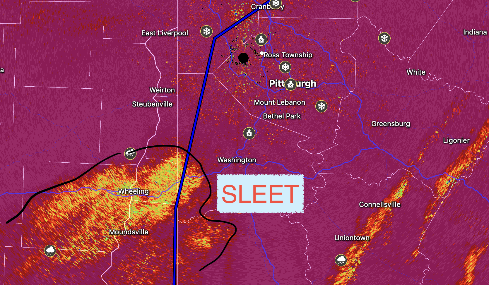
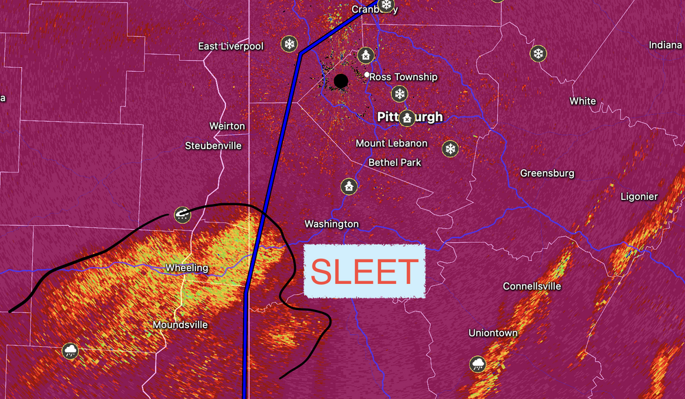
should be a brief period. Returns look solid on the radar just south of wheeling. No sign of sleet in them either -
Pittsburgh/Western PA WINTER ‘25/‘26
MikeB_01 replied to Burghblizz's topic in Upstate New York/Pennsylvania
And looking at the RAP, the 850 looks to transition from w-->e. No more northern progress -
Pittsburgh/Western PA WINTER ‘25/‘26
MikeB_01 replied to Burghblizz's topic in Upstate New York/Pennsylvania
yep. I don't want to celebrate early, but i like the way the radar looks. -
Pittsburgh/Western PA WINTER ‘25/‘26
MikeB_01 replied to Burghblizz's topic in Upstate New York/Pennsylvania
try this one for a composite view https://web.weatherwise.app/#map=4.72/39.62/-75.77&rt=KPBZ&rp=PRT0&m=COMPOSITE&cid=USA/MRMS&cr=CONUS&cp=SeamlessHSRPRT -
Pittsburgh/Western PA WINTER ‘25/‘26
MikeB_01 replied to Burghblizz's topic in Upstate New York/Pennsylvania
if you are trying to use the radar out of KPIT you will see lighter precip because of the distance. If you use a composite, there is plenty of snow falling in Zanesville -
Pittsburgh/Western PA WINTER ‘25/‘26
MikeB_01 replied to Burghblizz's topic in Upstate New York/Pennsylvania
i measured some spots in the backyard that have 4". I also measured some spots at about 7" My parents in Youngstown are measuring about 9-10" already -
Pittsburgh/Western PA WINTER ‘25/‘26
MikeB_01 replied to Burghblizz's topic in Upstate New York/Pennsylvania
1-1.5” per hour right now . -
Pittsburgh/Western PA WINTER ‘25/‘26
MikeB_01 replied to Burghblizz's topic in Upstate New York/Pennsylvania
Near whiteout. Awesome scene! . -
Pittsburgh/Western PA WINTER ‘25/‘26
MikeB_01 replied to Burghblizz's topic in Upstate New York/Pennsylvania
I’m out right now. No sleet. All snow . -
Pittsburgh/Western PA WINTER ‘25/‘26
MikeB_01 replied to Burghblizz's topic in Upstate New York/Pennsylvania
puking snow in bethel. Absolutely ripping -
Pittsburgh/Western PA WINTER ‘25/‘26
MikeB_01 replied to Burghblizz's topic in Upstate New York/Pennsylvania
please be all snow. -
Pittsburgh/Western PA WINTER ‘25/‘26
MikeB_01 replied to Burghblizz's topic in Upstate New York/Pennsylvania
HRRR has kinds been hinting at this so far this morning. However, even if it changes over in AGC, im hoping it is brief and right back to snow -
Pittsburgh/Western PA WINTER ‘25/‘26
MikeB_01 replied to Burghblizz's topic in Upstate New York/Pennsylvania
The CC on the radar seems to be looking more uniform which would indicate snow -
Pittsburgh/Western PA WINTER ‘25/‘26
MikeB_01 replied to Burghblizz's topic in Upstate New York/Pennsylvania
inching closer... Stay away from me. -
Pittsburgh/Western PA WINTER ‘25/‘26
MikeB_01 replied to Burghblizz's topic in Upstate New York/Pennsylvania
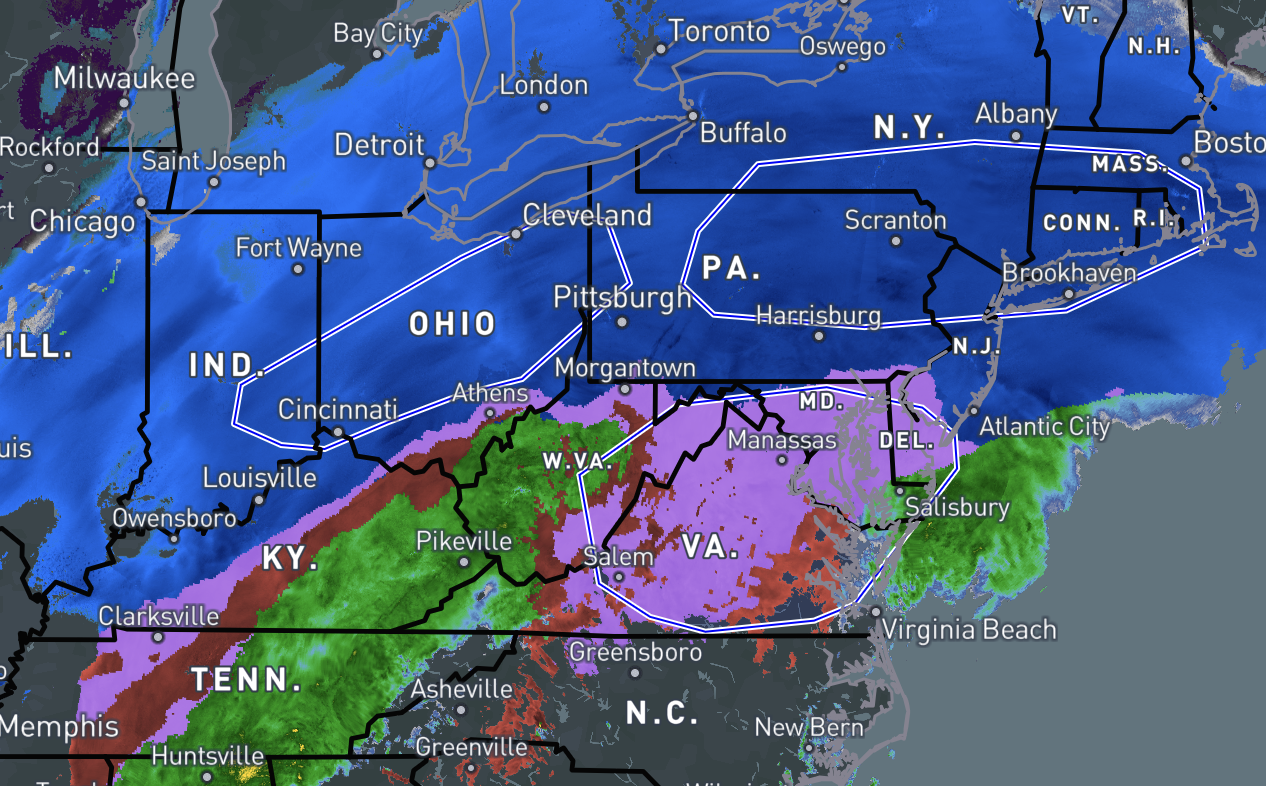
all mesoanalysis maps have the 0°c line well south of here, but reports are of sleet in morgantown and wheeling. So im not sure how much to trust the meso thermo profiles right now. A SPC discussion mentions peak frontogenesis running through pittsburgh. Just need to hope that the sleet rides east on that front and doesn't progress north -
Pittsburgh/Western PA WINTER ‘25/‘26
MikeB_01 replied to Burghblizz's topic in Upstate New York/Pennsylvania
What a scene outside! Puking snow right now -
Pittsburgh/Western PA WINTER ‘25/‘26
MikeB_01 replied to Burghblizz's topic in Upstate New York/Pennsylvania
-
Pittsburgh/Western PA WINTER ‘25/‘26
MikeB_01 replied to Burghblizz's topic in Upstate New York/Pennsylvania
and to be snowing this hard while it is 12° out. Super impressive -
Pittsburgh/Western PA WINTER ‘25/‘26
MikeB_01 replied to Burghblizz's topic in Upstate New York/Pennsylvania
i noticed that too. Reports of sleet in morgantown. -
Pittsburgh/Western PA WINTER ‘25/‘26
MikeB_01 replied to Burghblizz's topic in Upstate New York/Pennsylvania
Armstrong county - 2ft .