

MikeB_01
-
Posts
2,125 -
Joined
-
Last visited
Content Type
Profiles
Blogs
Forums
American Weather
Media Demo
Store
Gallery
Everything posted by MikeB_01
-

Pittsburgh/Western PA WINTER ‘25/‘26
MikeB_01 replied to Burghblizz's topic in Upstate New York/Pennsylvania
i thought i was crazy when i didnt see anything with reflectivity but could see if snowing outside. I did a little research and figured out that sometimes correlation coefficient sniffs out these low level pixie dust snows. Just thought that was pretty cool -
Pittsburgh/Western PA WINTER ‘25/‘26
MikeB_01 replied to Burghblizz's topic in Upstate New York/Pennsylvania
see... i'm not crazy lol -
Pittsburgh/Western PA WINTER ‘25/‘26
MikeB_01 replied to Burghblizz's topic in Upstate New York/Pennsylvania
Pretty positive movement today . -
Pittsburgh/Western PA WINTER ‘25/‘26
MikeB_01 replied to Burghblizz's topic in Upstate New York/Pennsylvania
thats a hard pill to swallow, but it isnt like we are starting from scratch. We have a solid 10-15" snow pack on the ground. 2" would be awesome to watch fall on top -
Pittsburgh/Western PA WINTER ‘25/‘26
MikeB_01 replied to Burghblizz's topic in Upstate New York/Pennsylvania
Might get some remnants of the squall . -
Pittsburgh/Western PA WINTER ‘25/‘26
MikeB_01 replied to Burghblizz's topic in Upstate New York/Pennsylvania
Significantly. I’m sure it had some lake enhancement and is losing its luster as it dives southeast . -
Pittsburgh/Western PA WINTER ‘25/‘26
MikeB_01 replied to Burghblizz's topic in Upstate New York/Pennsylvania
This looks frigid for us. . -
Pittsburgh/Western PA WINTER ‘25/‘26
MikeB_01 replied to Burghblizz's topic in Upstate New York/Pennsylvania
Snow squall warnings all over the Cleveland metro and points southwest. . -
Pittsburgh/Western PA WINTER ‘25/‘26
MikeB_01 replied to Burghblizz's topic in Upstate New York/Pennsylvania
Based on this and the analogs that I shared earlier, I don’t think it’s crazy to keep it on the table. I don’t think we will get 8+, but not a bad look to hope for a 2-3” event. Plus it will be so cold everything will pile up quick . -
Pittsburgh/Western PA WINTER ‘25/‘26
MikeB_01 replied to Burghblizz's topic in Upstate New York/Pennsylvania
even if the models are not showing anything, we still have analogs in our favor. Here is the mean snowfall for the time period on the GFS -- would seem to indicate a decent chance for a 1-3 or 2-4 snowfall. At least we can hope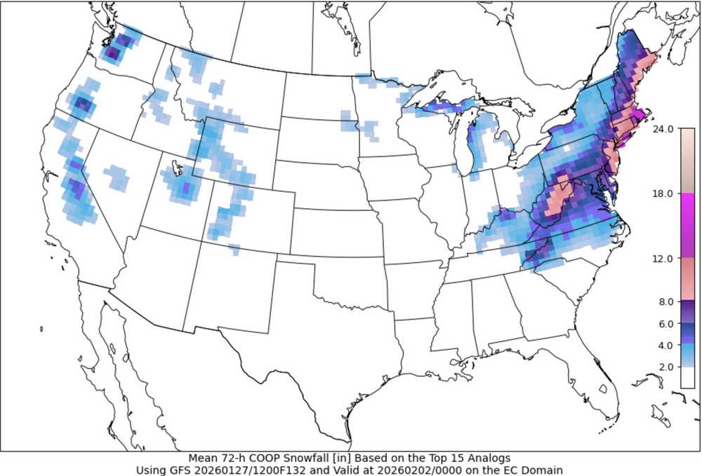
-
Pittsburgh/Western PA WINTER ‘25/‘26
MikeB_01 replied to Burghblizz's topic in Upstate New York/Pennsylvania
Can we squeeze another .5”? . -
Pittsburgh/Western PA WINTER ‘25/‘26
MikeB_01 replied to Burghblizz's topic in Upstate New York/Pennsylvania
i think nws pit gave it a 10% chance of giving us 1-3. -
Pittsburgh/Western PA WINTER ‘25/‘26
MikeB_01 replied to Burghblizz's topic in Upstate New York/Pennsylvania
i think it will get there. Where the clouds have cleared over ohio, the temps are plummeting. just need to get the stubborn clouds to move out. If you check the satellite imagery, they are moving. -
Pittsburgh/Western PA WINTER ‘25/‘26
MikeB_01 replied to Burghblizz's topic in Upstate New York/Pennsylvania
i said it late last night, but for once, the DWTOD didnt win. And i thought it was modeled extremely well -
Pittsburgh/Western PA WINTER ‘25/‘26
MikeB_01 replied to Burghblizz's topic in Upstate New York/Pennsylvania
Just wondering why they included the 14 from and the 18! From Monessen and New Stanton area? Gotta be drifts.. I might dig a little and try to find if that one came from a trained spotter or not. . -
Pittsburgh/Western PA WINTER ‘25/‘26
MikeB_01 replied to Burghblizz's topic in Upstate New York/Pennsylvania
record low for friday is -5°. Might be in jeopardy. -
Pittsburgh/Western PA WINTER ‘25/‘26
MikeB_01 replied to Burghblizz's topic in Upstate New York/Pennsylvania
so you're saying theres a chance... -
Pittsburgh/Western PA WINTER ‘25/‘26
MikeB_01 replied to Burghblizz's topic in Upstate New York/Pennsylvania
i too am feeling the withdrawal. So anything out there to track, im in -
Pittsburgh/Western PA WINTER ‘25/‘26
MikeB_01 replied to Burghblizz's topic in Upstate New York/Pennsylvania
not sure if it helps, but CoCoRaHs is a good place to see the liquid equivalent with the snow measurements matched up. Sometimes you need to look at the reports closely because they don't always report at the same time, but it may give some insight into the ratios we had yesterday. All in all, I just dont think we had a deep enough or saturated enough DGZ to maximize snow growth. Its why our ratios were so low. It also explain why areas to the north did better with the ratios. That and the really nice frontogenesis that set up around butler co yesterday -
Pittsburgh/Western PA WINTER ‘25/‘26
MikeB_01 replied to Burghblizz's topic in Upstate New York/Pennsylvania
some mood snow flying around out there right now. -
Pittsburgh/Western PA WINTER ‘25/‘26
MikeB_01 replied to Burghblizz's topic in Upstate New York/Pennsylvania
welp, I tried really hard to get it there, but im really close to the colonel and we got about the same. 11.4" An awesome storm - We beat the DWTD. Thats a win by itself -
Pittsburgh/Western PA WINTER ‘25/‘26
MikeB_01 replied to Burghblizz's topic in Upstate New York/Pennsylvania
It will be really interesting to see which model performed the best. . -
Pittsburgh/Western PA WINTER ‘25/‘26
MikeB_01 replied to Burghblizz's topic in Upstate New York/Pennsylvania
and just like that, the snow has shut off for me. I am going to get out here and do one final measure. Whether its over 12 or not, this was one hell of a fun storm to track. Well done, everyone. -
Pittsburgh/Western PA WINTER ‘25/‘26
MikeB_01 replied to Burghblizz's topic in Upstate New York/Pennsylvania
Crazy… I think with that last batch they might have got to 11. But I would have thought 12 was their total for sure . -
Pittsburgh/Western PA WINTER ‘25/‘26
MikeB_01 replied to Burghblizz's topic in Upstate New York/Pennsylvania
I’m a little skeptical based on the radar right now, but I’ll hope that there is something left. As soon as it’s done here, I’m going to go out and get a final measure. Hoping it’s over 12 .


