

MikeB_01
-
Posts
2,125 -
Joined
-
Last visited
Content Type
Profiles
Blogs
Forums
American Weather
Media Demo
Store
Gallery
Everything posted by MikeB_01
-

Pittsburgh/Western PA WINTER ‘25/‘26
MikeB_01 replied to Burghblizz's topic in Upstate New York/Pennsylvania
drying out pretty quickly behind this next line that is set to come through. Gotta squeeze as much as we can out it. -
Pittsburgh/Western PA WINTER ‘25/‘26
MikeB_01 replied to Burghblizz's topic in Upstate New York/Pennsylvania
mondo snowflakes right now. coming down! -
Pittsburgh/Western PA WINTER ‘25/‘26
MikeB_01 replied to Burghblizz's topic in Upstate New York/Pennsylvania
i also measured 11" total. I think we get at least another inch here in the next batch. We are going over 12" -
Pittsburgh/Western PA WINTER ‘25/‘26
MikeB_01 replied to Burghblizz's topic in Upstate New York/Pennsylvania
yes. We are going to get a few bursts still -
Pittsburgh/Western PA WINTER ‘25/‘26
MikeB_01 replied to Burghblizz's topic in Upstate New York/Pennsylvania
radar looking good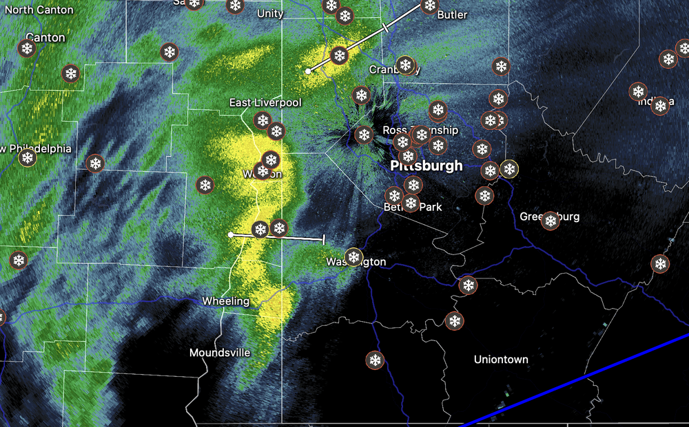
-
Pittsburgh/Western PA WINTER ‘25/‘26
MikeB_01 replied to Burghblizz's topic in Upstate New York/Pennsylvania
its coming.. I can smell it -
Pittsburgh/Western PA WINTER ‘25/‘26
MikeB_01 replied to Burghblizz's topic in Upstate New York/Pennsylvania
radar starting to really blossom again. Are there three inches in there? I dont know about that, but most are probably good for another couple -
Pittsburgh/Western PA WINTER ‘25/‘26
MikeB_01 replied to Burghblizz's topic in Upstate New York/Pennsylvania
yes should be better with the colder air aloft moving in. -
Pittsburgh/Western PA WINTER ‘25/‘26
MikeB_01 replied to Burghblizz's topic in Upstate New York/Pennsylvania
i believe the final call for the NWS was 11-15 -
Pittsburgh/Western PA WINTER ‘25/‘26
MikeB_01 replied to Burghblizz's topic in Upstate New York/Pennsylvania
I just think the ratios got to us down here. I know the dry air looms, but once the back side comes in, the ratios will be better. Still got a few inches on the table I think . -
Pittsburgh/Western PA WINTER ‘25/‘26
MikeB_01 replied to Burghblizz's topic in Upstate New York/Pennsylvania
Do they happen to have the liquid equivalent with that report? . -
Pittsburgh/Western PA WINTER ‘25/‘26
MikeB_01 replied to Burghblizz's topic in Upstate New York/Pennsylvania
Just checking in on the radar out of wilmington (oh). The snow out in the west parts of ohio has some pretty decent returns. Modeling continues to show that this will continue to move our way. -
Pittsburgh/Western PA WINTER ‘25/‘26
MikeB_01 replied to Burghblizz's topic in Upstate New York/Pennsylvania
dryer air definitely making it way to us, but HRRR still shows the backside holding together the dryer part clears out -
Pittsburgh/Western PA WINTER ‘25/‘26
MikeB_01 replied to Burghblizz's topic in Upstate New York/Pennsylvania
I'm sitting right around 9.5-10". So difficult to tell with the drifts. I measured anywhere from 6"-13" -
Pittsburgh/Western PA WINTER ‘25/‘26
MikeB_01 replied to Burghblizz's topic in Upstate New York/Pennsylvania
Same. Flakes are small, but the rate is great. . -
Pittsburgh/Western PA WINTER ‘25/‘26
MikeB_01 replied to Burghblizz's topic in Upstate New York/Pennsylvania
we are locked in the deep freezer for a while -
Pittsburgh/Western PA WINTER ‘25/‘26
MikeB_01 replied to Burghblizz's topic in Upstate New York/Pennsylvania
i agree. The report is coming in from a trained spotter, so i guess give him the benefit of the doubt. But that seems to be pretty high compared to what I am seeing out of my windows. I'll go measure here again in a little bit. Maybe my eyes are deceiving me. -
Pittsburgh/Western PA WINTER ‘25/‘26
MikeB_01 replied to Burghblizz's topic in Upstate New York/Pennsylvania
Only about 15 miles from me. I haven’t been out in a few hours, but I don’t think I’m over a foot yet. . -
Pittsburgh/Western PA WINTER ‘25/‘26
MikeB_01 replied to Burghblizz's topic in Upstate New York/Pennsylvania
Winds out of the south east, but would be shocked if there was some swirling. . -
Pittsburgh/Western PA WINTER ‘25/‘26
MikeB_01 replied to Burghblizz's topic in Upstate New York/Pennsylvania
The line really does seem to be holding at Washington co. Sleet south of there . -
Pittsburgh/Western PA WINTER ‘25/‘26
MikeB_01 replied to Burghblizz's topic in Upstate New York/Pennsylvania
definitely in progress. But we still have hours of snow. -
Pittsburgh/Western PA WINTER ‘25/‘26
MikeB_01 replied to Burghblizz's topic in Upstate New York/Pennsylvania
Dry air will start to win as the transfer happens from the primary to the coastal. But i think we snow for several more hours -
Pittsburgh/Western PA WINTER ‘25/‘26
MikeB_01 replied to Burghblizz's topic in Upstate New York/Pennsylvania
no. Not even close. Radar filling back in. looks solid for hours -
Pittsburgh/Western PA WINTER ‘25/‘26
MikeB_01 replied to Burghblizz's topic in Upstate New York/Pennsylvania
13" might be the winner so far -
Pittsburgh/Western PA WINTER ‘25/‘26
MikeB_01 replied to Burghblizz's topic in Upstate New York/Pennsylvania
i'll see if i can get a picture from my family. But based on what they are telling me. Might already be 13-14"


