

MikeB_01
-
Posts
1,824 -
Joined
-
Last visited
Content Type
Profiles
Blogs
Forums
American Weather
Media Demo
Store
Gallery
Posts posted by MikeB_01
-
-
Peak wind gust at my house (with the new weather flow station) was 23.8 mph. Seems low to me, but the system is said to still be calibrating itself. I also might need to change its set up a little bit. I have it on a PVC pipe and is secured, but does give way slightly when pushed. I’ve been trying to compare to stations around to see how accurate my station is
.-
 1
1
-
-
Pretty good lightning show going on in northern ohio. I would love to hear some thunder tonight
-
Not the most inspiring EPS... However, i think it is better than what it looks like at first glace. At this point of the year, I'll take almost any accumulating snow. 3 of the members have 5+ in and 36 members had 2+ in storms. Lots of time but I'm not feeling super optimistic.
-
12z GFS shows a very zonal flow after the exit of the system today and tomorrow. GFS looking like the GEFS from last night. Low goes off the Carolina coast.
-
GEFS doesn't look great either. Most members are taking the L off the Carolina coast. Not exactly where we want it
-
00z Euro is no good for anyone. East Coast included. Big H sitting over New England squashed that storm OTS
-
15 minutes ago, north pgh said:
Thunderstorms possible Tuesday evening according to SPC
winds will be screaming overhead at 500mb. 90-100 kts. The chance of that mixing down is probably the reason for the marginal outlook tomorrow.
-
-
Euro and GFS both have our system in sight. The difference between them is the timing between the moisture coming from the southwest and the kicker that is coming from the northwest. The kicker is slower in the GFS which is allowing the trough to tilt more neutral whereas the kicker is faster with the Euro and keeps our trough positively tilted. The GFS scenario allows the L to move up the apps SW to NE. Looks like the euro kick is keeping the system further south and moving more W to E eventually off the Delmarva
-
974 mb Noreaster on the 00z GFS. A radical change in the position of the H from the 18z to the 00z. Its much further west on the OOz which is allowing it to move up the coast. Definitely something to start watching. Especially if the Euro gets its act together a little more.
-
FWIW, that same storm is on the Euro as well. It is very unimpressive, nonetheless, it is there.
-
Dang... I wish this wasn't 7 days out. H5 looks like an awesome setup. Good energy and some cold air in place.
-
1 hour ago, Rd9108 said:
Euro just showed a monster storm for east long island and New England. This is looking good as far as the models finally catching on to a pattern change. I can imagine the gfs will start to catch on soon and we will start having atleast white storms to track. WAKE UP ITS COMING!!!!!
Teleconnections looking better too. Still, a lot of warmth to work through, but I do think there is a change coming somewhere around mid-late January
-
1
-
-
Looks like the MJO sees phase 8 and runs for cover. Wants to stay warm..

-
Yikes you know it's bad whenever JB who usually hypes up cold as much as possible is getting worried. Honestly one big blizzard would wipe away a horrible winter but right now its hard enough to get snowflakes in the air. It's just funny because everytime in the long range i does look promising. Then everytime we get closer it just gets progressively worse.
Listened to JBs video this morning. eeeekkk. I’ve never heard him sound so defeated. Like a dog with his tail between his legs.
Interesting at the very end he mentions all of the things that he expected to happen are happening but the weather just isn’t cooperating.
Outside of JB, the CPC has a colder than average outlook in the 3-4 week range. Long term Euro looks like it turns average but nothing to indicate cold yet.
.-
1
-
-
Just wanted to share with you guys. Super cool data coming in from my new WeatherFlow system. Installed it this week and am pumped to use it this winter. Here is the rainfall from tonight

.-
1
-
-
EPS 46 day starts to hint at a cooler pattern after the first week of January. Also worth noting that the models are also hinting at some blocking to the north. Could keep some cold air locked in for a decent stretch.
-
2 minutes ago, MikeB_01 said:
NAMs look decent, HRRR (00z run - 36hr) has almost no moisture hanging out on the backside. Hoping to get NAMed tomorrow night.
Also caught a glimpse of the 18Z Euro hourly model ( i didn't even know this existed). It looks very similar to the HRRR
-
NAMs look decent, HRRR (00z run - 36hr) has almost no moisture hanging out on the backside. Hoping to get NAMed tomorrow night.
-
1
-
-
By the time we go to bed on Christmas... Looks like we will be doing more than dreaming of a white christmas if this holds up

-
1
-
-
1 hour ago, dj3 said:
Chances the 3k Nam is on to something with this?
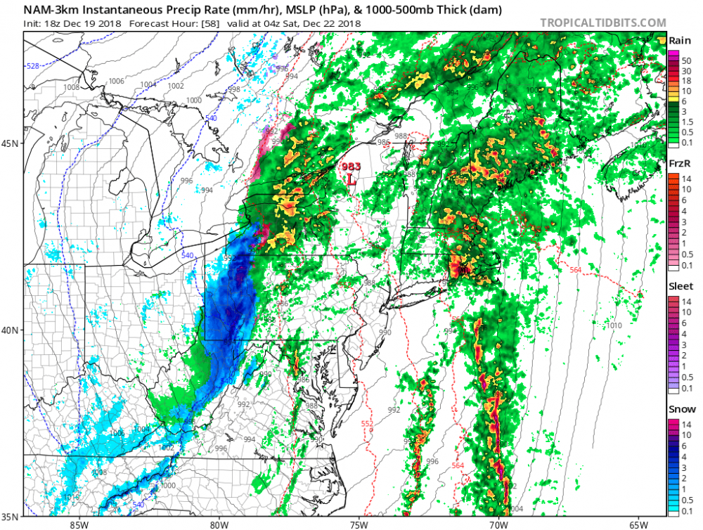
I don't usually buy into these backside snowmakers. Usually just not enough moisture to produce anything. However, it is interesting that the Euro has started to pick this up as well. 983 seems awfully low for the central pressure but again the Euro isn't too far off at 988. This is definitely something to keep watching.
-
Jeff V is saying he is going to continue to forecast on Twitter..is he even a fully degreed met?
https://www.post-gazette.com/ae/tv-radio/2018/12/17/Fired-meteorologist-Jeff-Verszyla-KDKA-weather-Pittsburgh/stories/201812170099
He was actually a fully degreed met. Mississippi State grad. Article talks about how one reason he was fired could be his skepticism of climate change.
. -
Christmas time storm looks better on the 500mb vort than it does at the surface. Something to watch. Unfortunately, just not a lot of cold air around right now.

-
A Christmas Torch...


✨Pittsburgh PA ❄ Winter 2018-2019
in Upstate New York/Pennsylvania
Posted
I got the Weather Flow sky and air. Super happy with them so far. They don’t spin or have tipping buckets, so it is a little challenging to tell the accuracy of them so early on. What is nice about them is the fact that the company is constantly pushing improvements to the system. So they only get better.
Here is the link for you guys to check out my data if you want to http:// https://smartweather.weatherflow.com/share/6001
.