

MikeB_01
-
Posts
1,827 -
Joined
-
Last visited
Content Type
Profiles
Blogs
Forums
American Weather
Media Demo
Store
Gallery
Posts posted by MikeB_01
-
-
Crazy. My backyard only made it down to 77°
. -
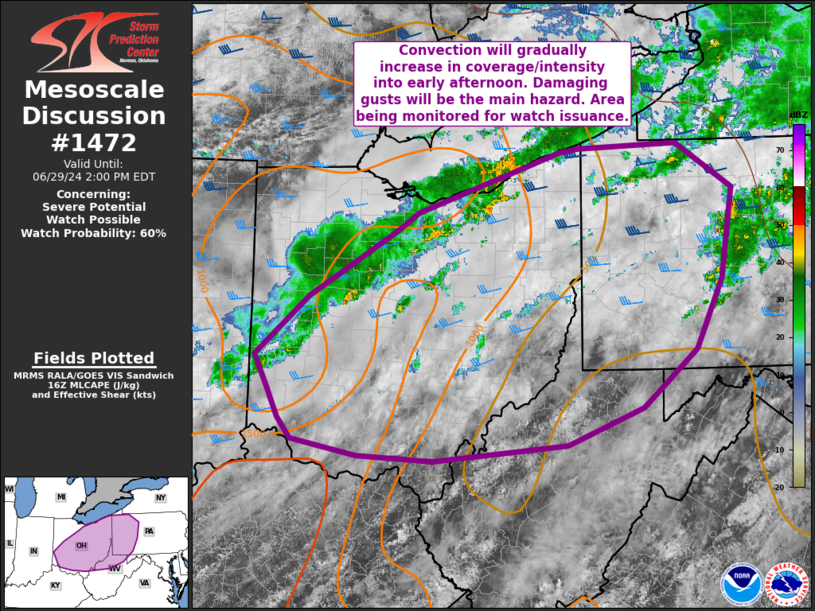
Mesoscale Discussion 1472 NWS Storm Prediction Center Norman OK 1103 AM CDT Sat Jun 29 2024 Areas affected...Portions of OH...northern WV...and western PA Concerning...Severe potential...Watch possible Valid 291603Z - 291800Z Probability of Watch Issuance...60 percent SUMMARY...Thunderstorms are expected to increase in coverage and intensity over the next few hours. Damaging gusts will be the main hazard with this activity, though a tornado or two also may occur. Timing of watch issuance is uncertain, but area is being monitored for watch issuance within the next couple of hours. DISCUSSION...Isolated convection has been slowly increasing along the leading edge of an area showers left over from overnight/early morning convection moving into northern/central OH. Rich boundary-layer moisture is in place, with surface dewpoints in the upper 60s to low 70s F noted in morning observations. Widespread cloudiness is limiting heating, and temperatures are generally in the upper 70s to near 80F. With time, pockets of stronger destabilization are expected into afternoon, with downstream destabilization expected into parts of northern VA/western PA by early to mid-afternoon. However, cloud cover and poor lapse rates may limit more widespread stronger instability. Nevertheless, vertical shear will be sufficient for transient supercells and bands of bowing segments. Damaging gusts will be the main hazard with convection through the afternoon and into early evening. While low-level shear will remain somewhat weak, vertically veering profiles will result in somewhat enlarge and curved low-level hodographs suitable for a tornado or two in addition to damaging gust potential. Additional convection is possible into the evening hours as the synoptic cold front (currently over northern IL) shifts east/southeast across the area. As a result, multiple bands/rounds of strong/severe storms are possible. Timing of watch issuance is a bit uncertain, but the trends will continue to be monitored for possible watch issuance within the next couple of hours. ..Leitman/Gleason.. 06/29/2024
A lot of the severe nature of today is hinging on these clouds getting out of here. Need some instability to get these storms going today
. -
No cool air in sight, i'm done wishcasting snow. Bring on the Spring!

-
A little under 3” so far here. With the last push here I’m hoping I can get over 3.5
. -
Certainly is beautiful
. -
Im trying to catch up, but I like the trends. Like @Mailman said, clippers tend to overachieve. With a good trend and keeping that in mind, I’m feeling positive about it right now.
. -
1 minute ago, Rd9108 said:
Maybe the models bust hard.... not likely
ahh the positivity. Never ending hope.
Honestly though, its not a crazy solution. A slight tick NW and we are in it.
-
Just now, CoraopolisWx said:
At least this board has always doubled as a weather enthusiast/support group location. lol
I don't know what i would do without you guys. No one else understands my frustration (or excitement --> when it happens)
-
 1
1
-
-
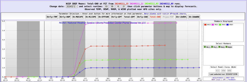
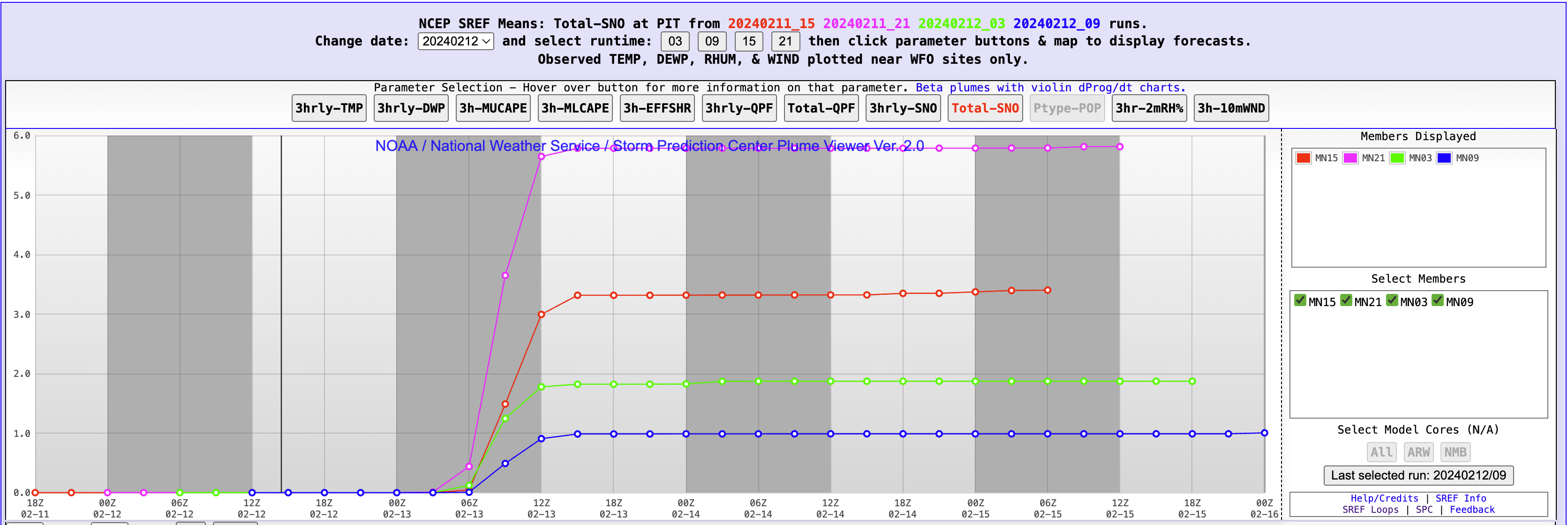
the SREF trends are comical
-
-
Wow!! The trend over the last few runs is crazy.
I’m hoping the windshield wiper effect is fully engaged. Settling somewhere in between
. -
23 hours ago, RitualOfTheTrout said:
We need some phase to get the NS involved though to get the cold, 6z GFS was really close to perfect, get that whole progression to happen a little faster and further SW and it bombs right over us vs central PA and look out. There in lies the the thread the needle aspect though, there aren't any other features to buy wiggle room, so it all has to time out perfectly which makes it even lower odds than normal.
But dang...
Missed posting about this yesterday....
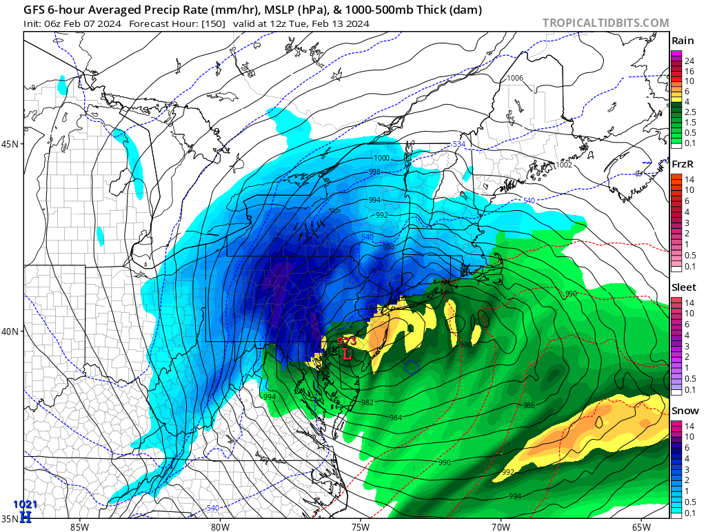
is this a Cat 2 hurricane over Delaware?
-
 1
1
-
-
-
this is me every single time i start the watching the run of the GFS and don't even see a fantasy storm. This pattern is rough. Hoping second half of February can bring something to cheer for.
-
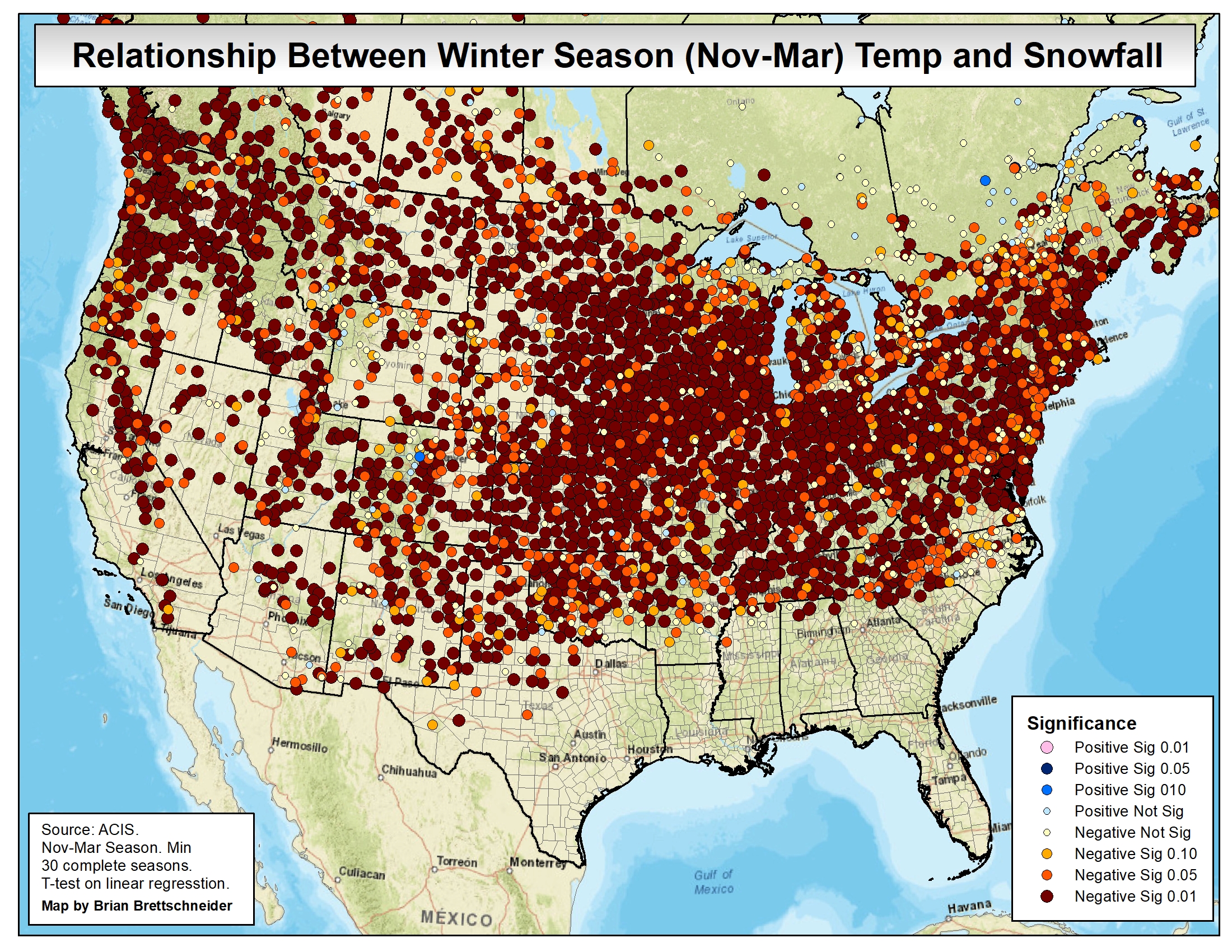
54 minutes ago, donyewest said:
I would beg to differ, credit to Brian Brettschneider @Climatologist49:
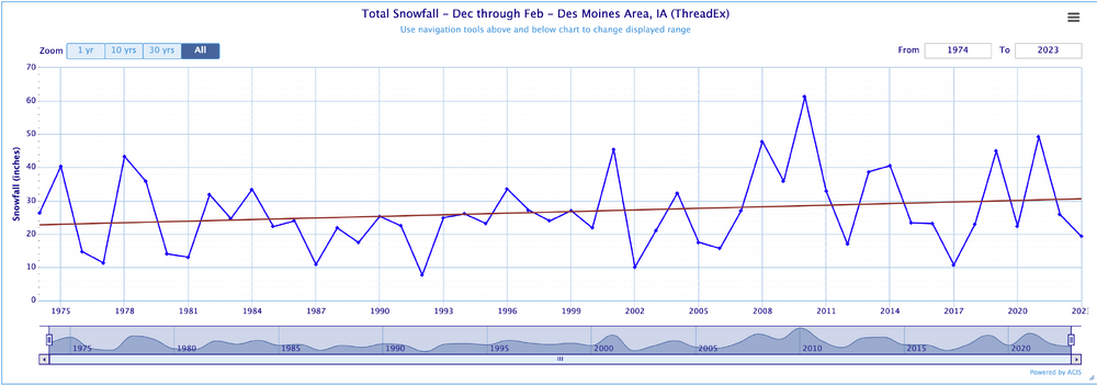
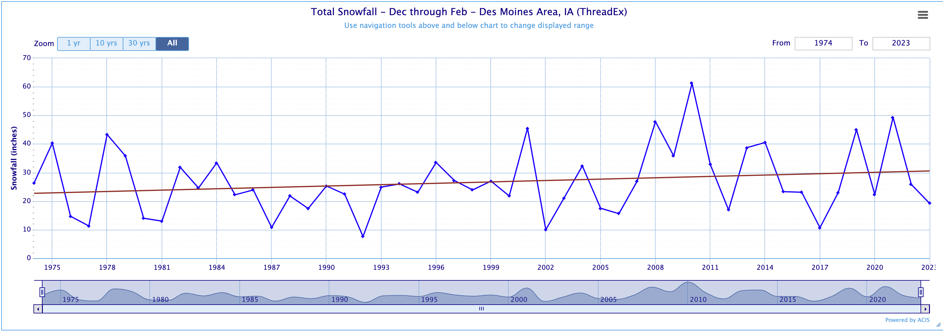
maybe im not understnding these charts the way they are suppsed to be understood, but i did the same thing for Des Moines, IA (an area highlights but -50% snowfall). This is what I got.
-
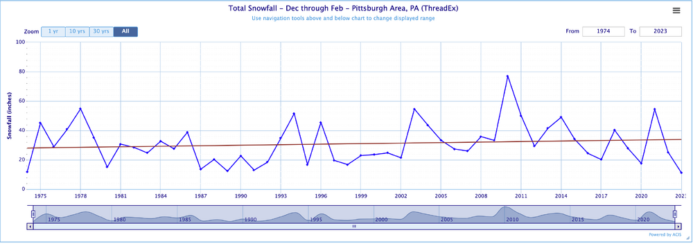
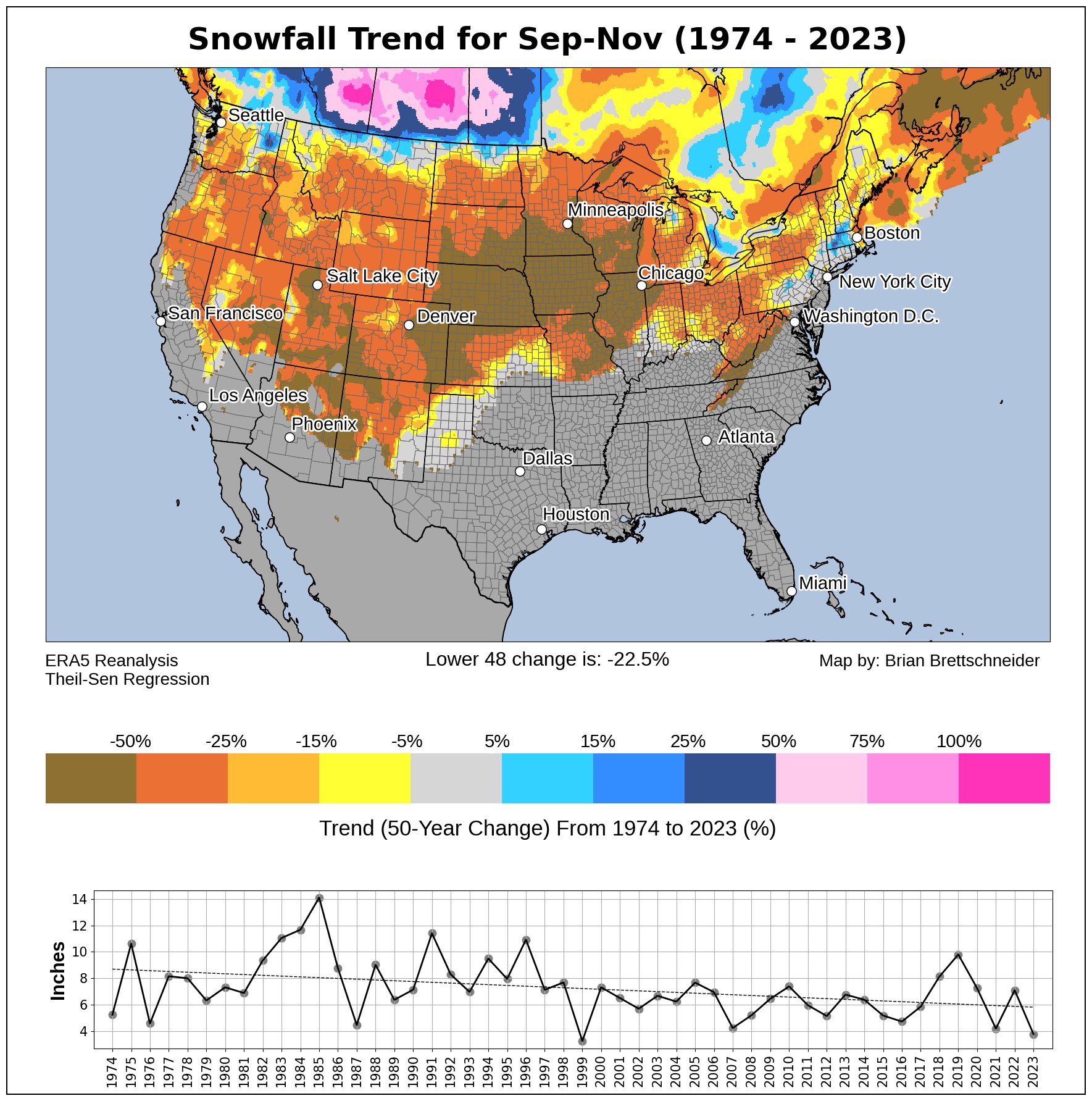
30 minutes ago, TheClimateChanger said:
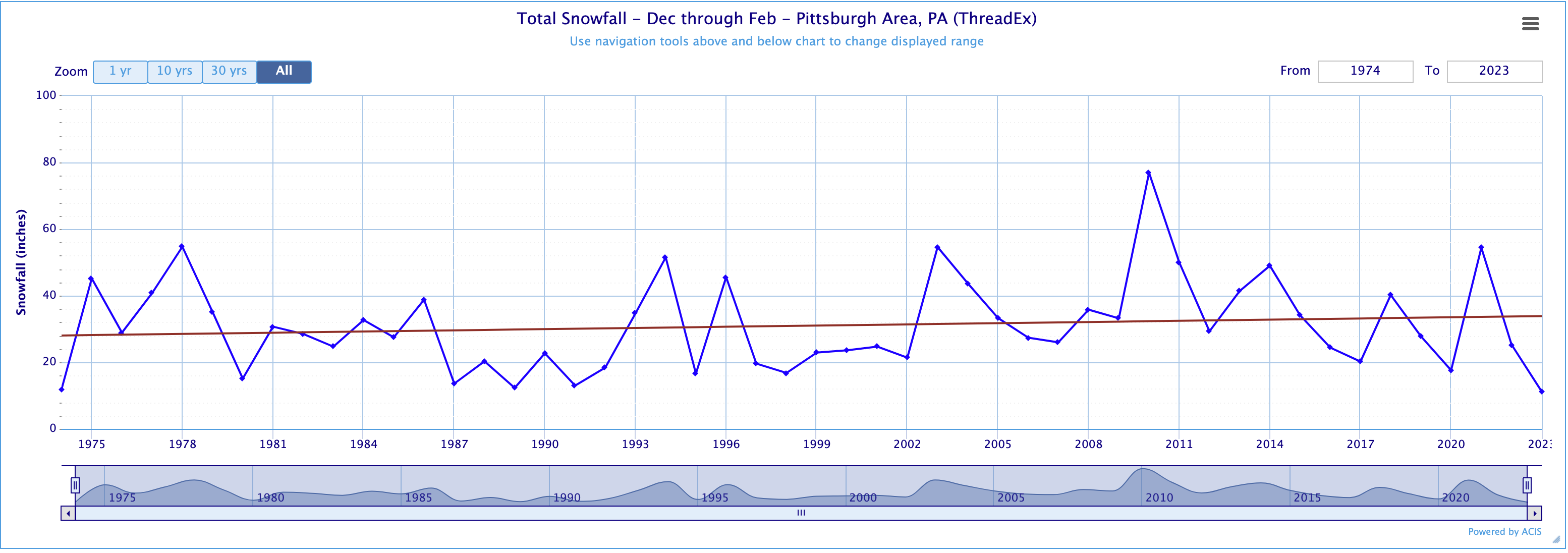
Keep in mind that data is subject to smoothing, and there can be variances. The linear regression at PIT over that interval is actually positive, with a slope of +0.05" (or a gain of about 2.5" over 50 years). But most locations around us are negative, and substantially so. Cleveland, for instance, shows a negative slope of -0.29" per year (or a loss of about 14.5" over 50 years). So it's sensitive to start and ending dates - 1973-1974 was a historically bad winter for Pittsburgh, but not as bad elsewhere.
-
16 minutes ago, PghPirates27 said:
Hit 50.5 Today!
I think i saw 52.0° AT 2:51 at KPIT. 16° above the average
-
Anyone peaking at sunday? Not a ton of cold air, but the GEFS is better than the Op GFS.
-
1 minute ago, TimB said:
Also, glad we missed out on the freezing rain, but is there a reason the advisory is still going? We’ve been above freezing the whole time, haven’t dropped below freezing, and won’t drop below freezing.
Its interesting how far off the HRRR was on the temperature for this morning...
I think because there are some stations (PWS) hovering right around freezing, they will leave it as is. My PWS was 32 this morning. I only had sprinkles and it wasn't freezing, but the temp read 32°
-
1 minute ago, MikeB_01 said:
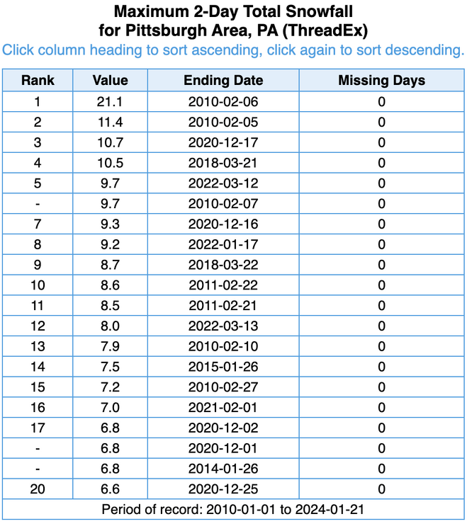
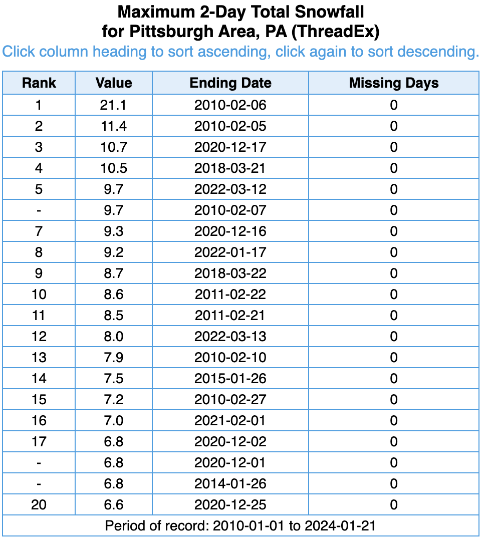
Our climo says that we get a 12" storm once every 14 years. We have had some 10"s, but has the airport gone over 12" since 2010?
Sorry if this question has been answered a bunch of times before
never mind. I just answered my own question
-
Our climo says that we get a 12" storm once every 14 years. We have had some 10"s, but has the airport gone over 12" since 2010?
Sorry if this question has been answered a bunch of times before
-
5 minutes ago, TimB said:
Mid 20s tomorrow morning seems too cold.
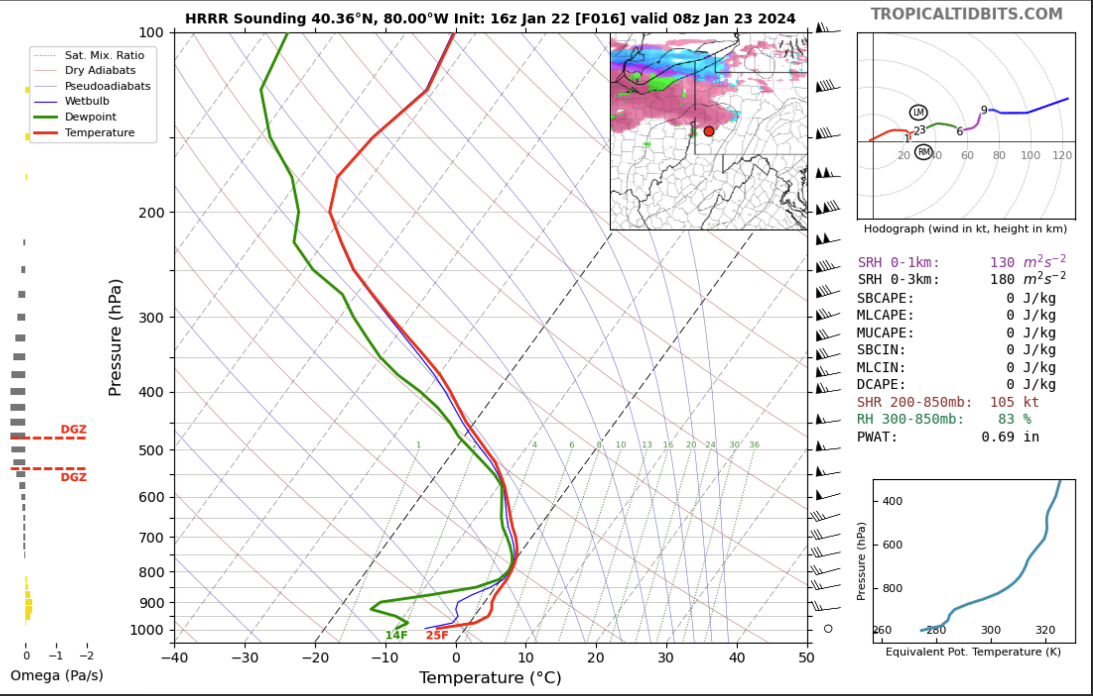
It does. HRRR seems to be alone in this thinking
-
Take a look at the sounding for the HRRR. Brutal temp profile for ZR. 25° at the surface.

-
1 minute ago, Rd9108 said:
Believe it or not we are around an inch above normal for snowfall for the month of January. Last year only .9 inches fell compared to 9.9. We are still way behind the average to date but Febuary and March could be rocking after this break in the pattern.
I like the positive mindset.
-
1
-


Pittsburgh/Western PA Winter 2024-2025 Thread
in Upstate New York/Pennsylvania
Posted
Snow globe in the south hills