

MikeB_01
-
Posts
1,824 -
Joined
-
Last visited
Content Type
Profiles
Blogs
Forums
American Weather
Media Demo
Store
Gallery
Posts posted by MikeB_01
-
-
SREFs have been trending up over the last few runs. Not crazy, but up from 2.5 to 3.5 over the last 3 runs
-
GFS is the same as well. 3-5
-
3 minutes ago, Rd9108 said:
Jeff V might even be predicting more than just some now showers!
"accumulations totaling 1"-18"" -- Jeff V snow forecast
-
 1
1
-
-
12z NAM looks to hold suit. 3-5
-
This has certainly improved from yesterday...
-
27 minutes ago, Mailman said:
this is a great sign.
-
 1
1
-
-
6 minutes ago, Rd9108 said:
More with ratios but NAM is bone dry

NAM initialization looked bad. Not sure what it is doing
-
6 minutes ago, Rd9108 said:
All of this negativity is making me not even wanna storm chase anymore.
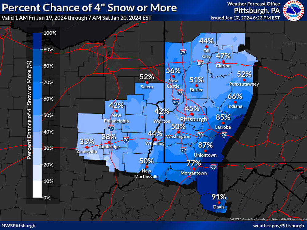
In all honesty, I am thinking that the NWS is being conservative with the 2" call. The track of the storm looks good. Lets hope is gains a little more strength and maybe we squeeze a 4-6" surprise out of this.
It is sad that I am hoping for a 4" storm, but that is where we are at...We will get there eventually
-
2 minutes ago, TheClimateChanger said:
Interestingly, the NWS in Charleston is strategically lining up winter storm watches all along the southern boundary with Pittsburgh's CWA. Yet PBZ isn't even sure if advisories will be warranted.

Other neighboring offices are also going with watches in the higher terrain, and NWS CLE has posted watches in north central Ohio where lake enhancement can lead to more than 6 inches.
one of the biggest problems with the NWS is lack of communication with other offices.
-
15 minutes ago, TimB said:
It’s been the same old story over and over again for every single snow event that’s happened the past two winters. Today’s NWS discussion:
- Snow chances increase on Thursday, but the main focus for
  widespread accumulations will be Thursday night and Friday.
  Snow accumulation could exceed criteria for headlines, but
  current probabilities are pointing to the highest threat in
  the ridges.

-
-
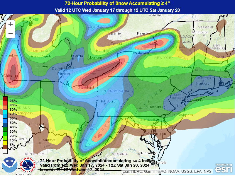
2 hours ago, RitualOfTheTrout said:
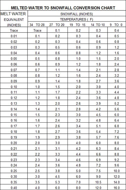
Quick glance all 12z models have us in at least the .3 - .4 qpf range which is probably good for a 3-5 inch setup. Would be nice to improve or hold on that. Canadian looking the best as usual lol
based on this chart, i think we would be happy with that QPF
-
Coming down right now. Beautiful

-
1
-
-
Really it looks like this set up quite a bit NW of predicted. However, I don’t really know if this was an extra piece that rolled through. I didn’t expect to see such a large area of snow NW of us.
Maybe this can be one of those days where snow falls all day and just doesn’t dissipate.
Yeah, I actually think the areas north and west will do better than south and east. Here in bethel park I have about .5” that’s it.
.-
1
-
-
Anyone on the board getting any snow yet? Radar looking good from south to north. County airport reporting light snow.
Yes. Snowing in Bethel Park. Already have a coating on cars and driveway.
. -
If we get 2-3, id be happy with it. Not bad considering the weakness of this system
-
honestly, not a bad position heading into tonight. I dont think anyone is getting 4" out of this, but the HRRR has been trending a little north and west. Also the SREFS have PIT at 2". I think we could see a situation where some in the northwest part of the area are around 1" and some in the southeast are 3"
-
-
1 hour ago, Rd9108 said:
Euro is better but still not great. Maybe it's the beginning of a positive trend. It will be interesting to see the ensembles. I wouldn't expect too much from this but some cold 2-4 inches would go a long way.
Its a good point. For reference the 00z EPS showed the main run at the very bottom of members. Lots of options showing more snow
-
I like the positivity in here today
-
3 minutes ago, TheClimateChanger said:
We are so overdo for a 12"+ calendar day, it's not even funny. I'm not sure this streak will ever end. Might be permanent.
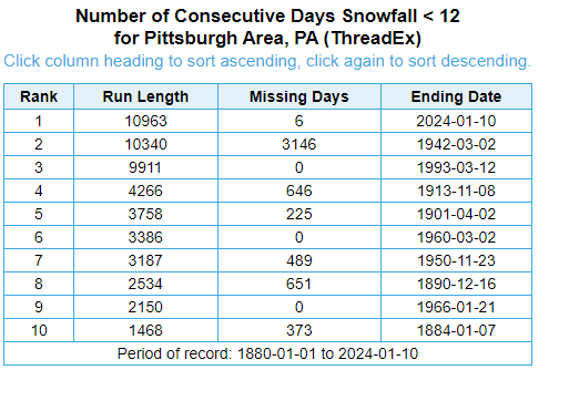
thats is insane... 1994
-
1 minute ago, MikeB_01 said:
Monday/Tuesday next week has me very intrigued at this point. Euro much more aggressive with it. The energy at the 500mb levels get their act together and nearly get negatively tilted. The GFS is much less aggressive. The energy is more stretched out. Never really allowing it to get going. Lots of members on the EPS also show a more dynamic system. GEFS has some, but still seems kind of lost on much of a system.
Definitely something to watch in the next few days. Hopefully things start trending toward the Euro.
Regardless, both ensembles show it to be pretty darn chilly after the front moves through..

-
2 hours ago, RitualOfTheTrout said:
I'm wondering if after this next cutter we get some better snow action on the back-end with some true arctic air coming in over very warm lake waters if we can get a favorable trajectory and a little embedded shortwave to help mix things up.
Storm after is till on the Euro, and GFS seems to be at least showing the possibility of something in the same time frame too.
Monday/Tuesday next week has me very intrigued at this point. Euro much more aggressive with it. The energy at the 500mb levels get their act together and nearly get negatively tilted. The GFS is much less aggressive. The energy is more stretched out. Never really allowing it to get going. Lots of members on the EPS also show a more dynamic system. GEFS has some, but still seems kind of lost on much of a system.
Definitely something to watch in the next few days. Hopefully things start trending toward the Euro.
-
I would love for people to stop arguing in the main thread… that is all.
.-
2
-


Pittsburgh, Pa Winter 2023-24 Thread.
in Upstate New York/Pennsylvania
Posted
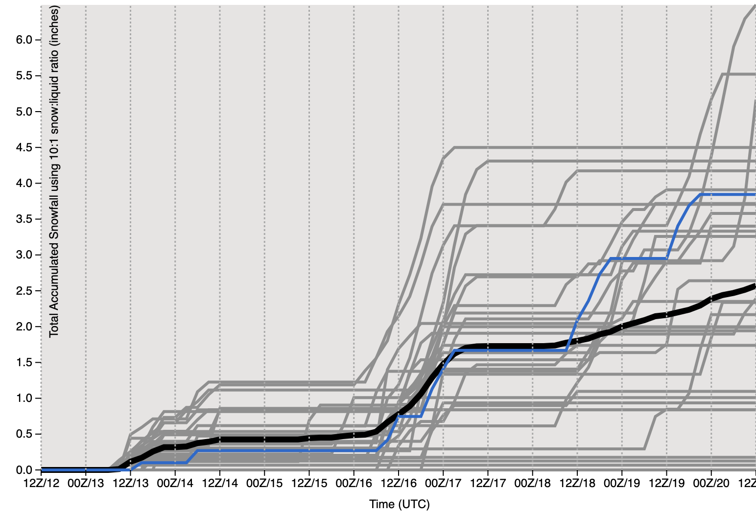
Euro in line as well. This is the 10:1 ratio. If you go with the expected ratios, looking more like 4.5" from this