

MikeB_01
-
Posts
1,824 -
Joined
-
Last visited
Content Type
Profiles
Blogs
Forums
American Weather
Media Demo
Store
Gallery
Posts posted by MikeB_01
-
-
2 minutes ago, Rd9108 said:
Looks like this crazy storm broke the gfs.
Yeah, NCEP saying GFS running about 30 minutes behind.
-
Pretty nice shift SE on the CMC
-
 1
1
-
-
4 minutes ago, olafminesaw said:
I wouldn't underestimate this beast

never trust a cut off low.
-
I don't think i have ever seen the flag come out this early.
Come on guys. One run of one model. Stay in the game. The fact is that we are 6 days out and have a system in play. Lets watch for a few days

-
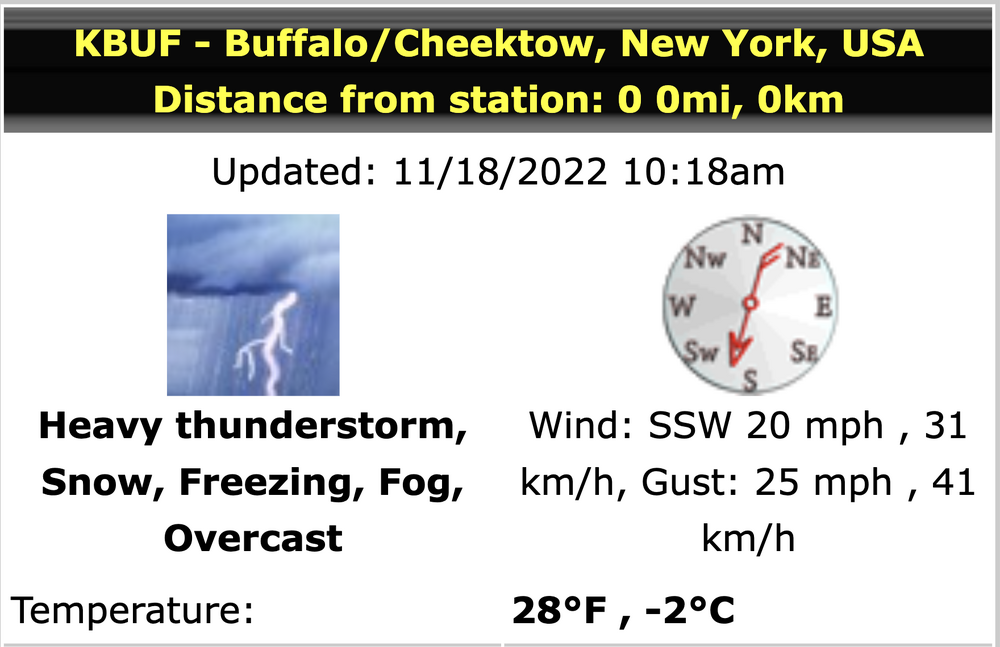
just for fun. Current weather in Buffalo
-
This slug of rain has me ready for a good thump of snow
. -
Hot take: the GFS is garbage.
.-
2
-
-
We’re getting pretty close to that “we really need rain” stage. Wouldn’t say it’s dire yet, but we could well be dry through the weekend if we miss out today. But I’ve really enjoyed not mowing, so maybe I shouldn’t be worried.
I’m ready at least for a little bit. I’m not looking for ton of rain, but a nice thunderstorm here and there would work wonders. I love landscape and gardening, this has been a tough stretch on my plants
. -
Could we escape today without any real rain?
Yes. HRRR runs after 18z yesterday really backed off of the rain west of the city. Everything forming south and east. Looks like that is holding true on radar
. -
I went to the website cited in that article and generated this for KPIT. It uses available hourly data for the temp and dew point to generate a heat index. Extends back to 1945. According to this, since 1945, the maximum hourly heat index at PIT was 106F observed at 2 PM on June 27, 1978. Last week's heat wave tied the highest recorded heat indices for any June day (dating to 1945) for the 8 PM hour (96F) and 10 PM hour (91F). Keep in mind since this is based solely on hourly data, there could be a higher intra-hour reading.
Here's the link: https://mesonet.agron.iastate.edu/plotting/auto/?_wait=no&q=153&network=PA_ASOS&zstation=PIT&month=jun&var=max_feel&_r=t&dpi=100&_fmt=png
This is such a good website for data. I can never figure out how to work it. Thanks for the data
. -
Anyone else noticing the yellow sky? Crazy how comfortable it is out there. Very odd looking sky with sunset reflecting off these clouds.
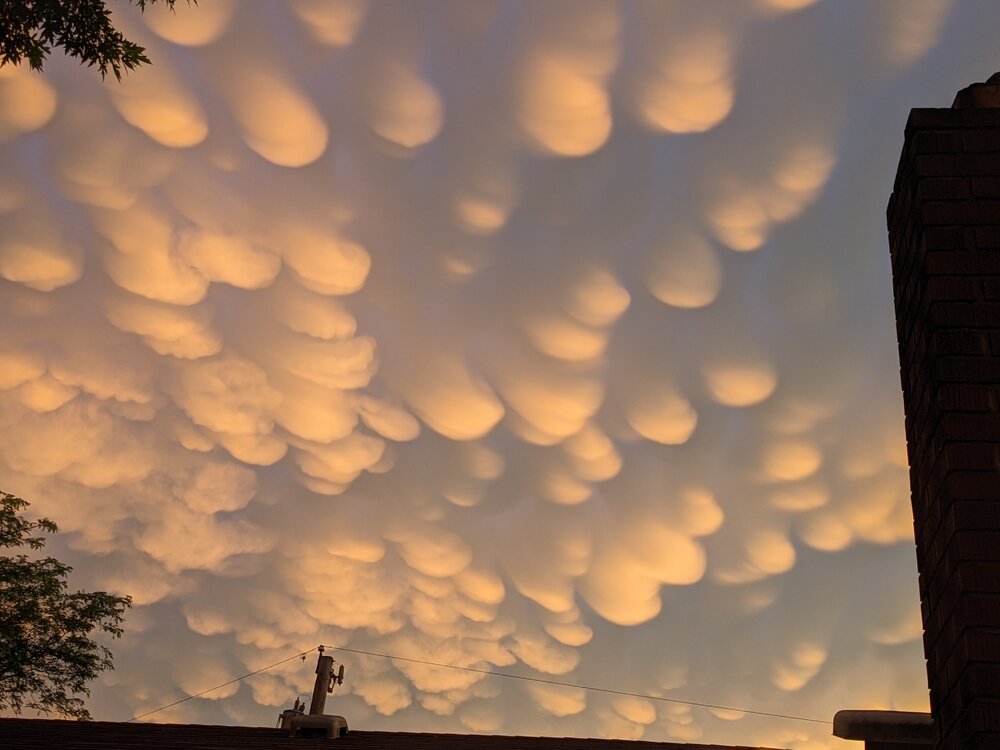
What a great picture of some mammatus. Don’t see that too often around here
. -
I still have no clue how it didn’t rain in AGC
.-
2
-
-
Serious question. How does the convection split like that? What is the inhibiting factor that is causing nothing in between two very impressive lines
. -
Looking at the HRRR and RAP they aren’t really showing much if any convective development this afternoon.
Hires NAM shows it a bit more, but all of the models show a very broken line and large breaks right over us.
Radar is starting to develop out in central Ohio. Looking a little more robust than the earlier runs of the models
. -
This is awful. I would never root for weather like this.
It’s hot for sure. However, if the alternative is the 38° and rainy days we get in the middle of March, I’ll take this day please
.-
1
-
-
93.0°and a 79.8° dew point on my PWS.
Not the most accurate, but not that far off either. It’s scorching out there
. -
Back to rain in the south hills. It had transitioned to snow and sleet. At least in Bridgeville I have rain
. -

Waking up this morning and looking outside…
. -
Roads just look wet, hopefully they stay that way. Kind of doubt it though.
The snow and cold will win out. The roads and other paved surfaces are resisting because of how warm it got today. Couple of hours and they will give in
.-
1
-
-
1 minute ago, Ecanem said:
NWS doubling down... Love it.
-
1
-
-
guys, admittedly, i'm getting to the party late. But things look ok right now?
-
I have golf balls falling from the sky right now. Mondo flakes in the south hills
. -
Yeah…really looks like the bulk of this will slide by just north.
Just relax man. I’m down in the south too. We might not see 35-40dbz but the line is still moving this way. Just be patient. You will see good rates in the next 30 mins or so
. -
mondo flakes outside right now


Pittsburgh, PA/Western PA Fall/Winter Discussion 2022-23
in Upstate New York/Pennsylvania
Posted
I always like the check the SREFs. Not the most reliable, but still fun to look at.
Hovering right around 1" of snow. All falling with the passage of the front. The temps will be brutal by midday and not much change for 48 hours. Very impressive for December.