

MikeB_01
-
Posts
1,824 -
Joined
-
Last visited
Content Type
Profiles
Blogs
Forums
American Weather
Media Demo
Store
Gallery
Posts posted by MikeB_01
-
-
Looks like the 6z gfs and ensembles started ticking back north, and none of the other models really moved south. I’d guess that the death knell for us on this. Wasn’t expecting anything really but is going to suck that once again 100 miles away is going to get crushed again.
I just hope we can avoid any sort of icing.
Seems very unlikely at this point. There will be ice
. -
The GFS needs to stop playing with my heart. Honestly, even though it is the furthest SE, it really isn’t that far fetched. It’s just a predominantly stationary frontal boundary that the energy runs along. If that boundary is suppressed like the GFS it’s game time
. -
4 minutes ago, KPITSnow said:
Agree. I'll take the NAM solution of 33 and rain as opposed to some solutions that are 29 and freezing rain.
33 and rain is like kissing your sister or coming to a draw in the super bowl.
-
6 minutes ago, KPITSnow said:
It also has shifted pretty far north.
Thats ok at this point. It is very likely to wobble back and forth. Good trends today
-
we're back baby!
-
20 minutes ago, RitualOfTheTrout said:
Did anyone notice Tropical Tidbits now has Euro precip maps / 500 maps (including 6z / 18z runs)? I prefer TT interface to Pivotal, maybe I've just been using it longer and I'm old lol but I was happy to see that addition.
just noticed this! Thank you. TT is way more user friendly. Not that there is anything wrong with Pivotal, but TT is a little bit easier to navigate.
-
Well, the NAM was also the first one almost from 84 hours out to latch on to the dry slot with the MLK storm, so who knows?
Positive vibes! This is refreshing. Well done sir
. -
Snow globe right now. Looks awesome outside.
-
 1
1
-
-
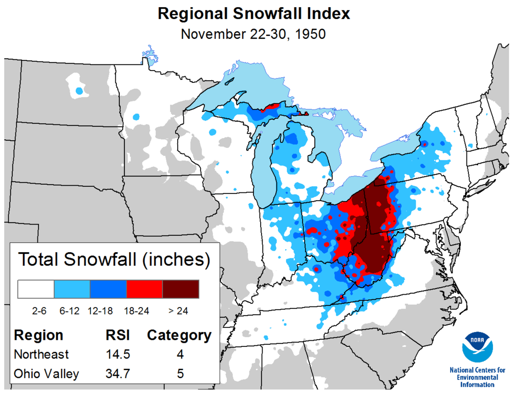
I think we can all agree we just need another one of those November 1950 storms and we'll all be satisfied.

. -
Ok now that this one has wound down... Lets do it again tomorrow with another 2-3"
-
Snow puke right now
.-
1
-
-
Snow has been pretty weak down here all morning. Really fine and lightly falling. Maybe picked up 1/2” so far. Looks like a band with better returns getting ready to move in. Hopefully can get an inch out of this band.
. -
Clipper has trended a little north and stronger. We’ll see if someone can pop 3-4” out of this.
NAM, HRRR?
. -
Clipper tomorrow is looking worse and worse. NAM 3k gives Pittsburgh almost nothing.

. -
lol gfs is back to a big bomb storm that destroys the east coast. The ensembles should be fun to look at.

Right where we want it this far out.
50 mile shift each day and we get snow bombed
. -
...WINTER WEATHER ADVISORY IN EFFECT FROM 7 AM TO 7 PM EST SUNDAY...
* WHAT...Snow expected. Total snow accumulations between 2 and 4
inches.
* WHERE...Portions of east central Ohio. Portions of southwest and
western Pennsylvania. Portions of northern and the northern
panhandle of West Virginia.
* WHEN...From 7 AM to 7 PM EST Sunday.
* IMPACTS...Plan on slippery road conditions.
PRECAUTIONARY/PREPAREDNESS ACTIONS...
Slow down and use caution while traveling. The latest road
conditions for the state you are calling from can be obtained by
calling 5 1 1.
&&
. -
-0.6° for about an hour this morning. That’s a win.
. -
Still 10 at KPIT
14 in the city.
. -
Living in heat wave. 9.3° for me.
. -
2 hours ago, dj3 said:
Have to laugh at this.
Appears that period is very boom or bust for someone in the eastern us.Just your casual 20+" snowstorm in eastern Georgia
-
Interesting how much the overnight cloud cover was under-forecast. NWS had a forecast low of 4 but it looks like PIT never reached single digits.
Edit: I spoke too soon. Looks like the 8:10 obs was 9.
I made it to 9 on my PWS. Looks like it was way more cloudy between 1 am and 5 am than what they thought.
. -
1 hour ago, Ahoff said:
GFS has been better this year, lol. Maybe that's it. 24th-25th was a period mentioned for possibly something.
He's also keeps PM snow for Sunday too. Not sure why?
1 hour ago, TimB84 said:TWC sees the Monday-Tuesday thing as a possible low end advisory type event, and is carrying a chance of snow on Sunday, so maybe he got it from there?
Sunday is the clipper no?
-
Interesting to hear Smily this morning talking about accumulations of more than 1" for next tuesday. I think he is talking about the bowling ball of a cut off low that is going to find itself sitting out over Arizona. The GFS shows this eventually getting caught up in a relatively zonal flow and moving east towards us with some form of precipitation. From what I can tell, the GFS is the only one picking up on this energy moving in our direction. Euro has it south and never really materializing. Am I missing something here?
-
1 minute ago, Ahoff said:
Have a coating at my house.
Same here and a few streamers coming in from the north. Doesn't look like anything substantial, but maybe if you get under something decent, you can pick up another 1/4-1/2 inch.
-
1
-


Western PA/Pittsburgh Winter 2021/22 Discussion
in Upstate New York/Pennsylvania
Posted
GFS looking very similar to 6z thru 48hr