

MikeB_01
-
Posts
1,827 -
Joined
-
Last visited
Content Type
Profiles
Blogs
Forums
American Weather
Media Demo
Store
Gallery
Posts posted by MikeB_01
-
-
Just now, Burghblizz said:
Yinz are going to drive yourselves nuts clicking on hourly increments of hourly models for the 8 hours, and checking where the pretty colors line up.
I think E to W across central AGC will be the difference between 8 and 12 because of dry slot duration. And N to S along that axis will add or subtract ~2” from that range.
Beaver /Lawrence/Butler certainly have a shot to pop a 15” total.
Clicking the hourly increments is what i live for lol
-
 2
2
-
 2
2
-
-
1 minute ago, Rd9108 said:
Would be very satisfied and we could still get higher if that low is 50 miles east.
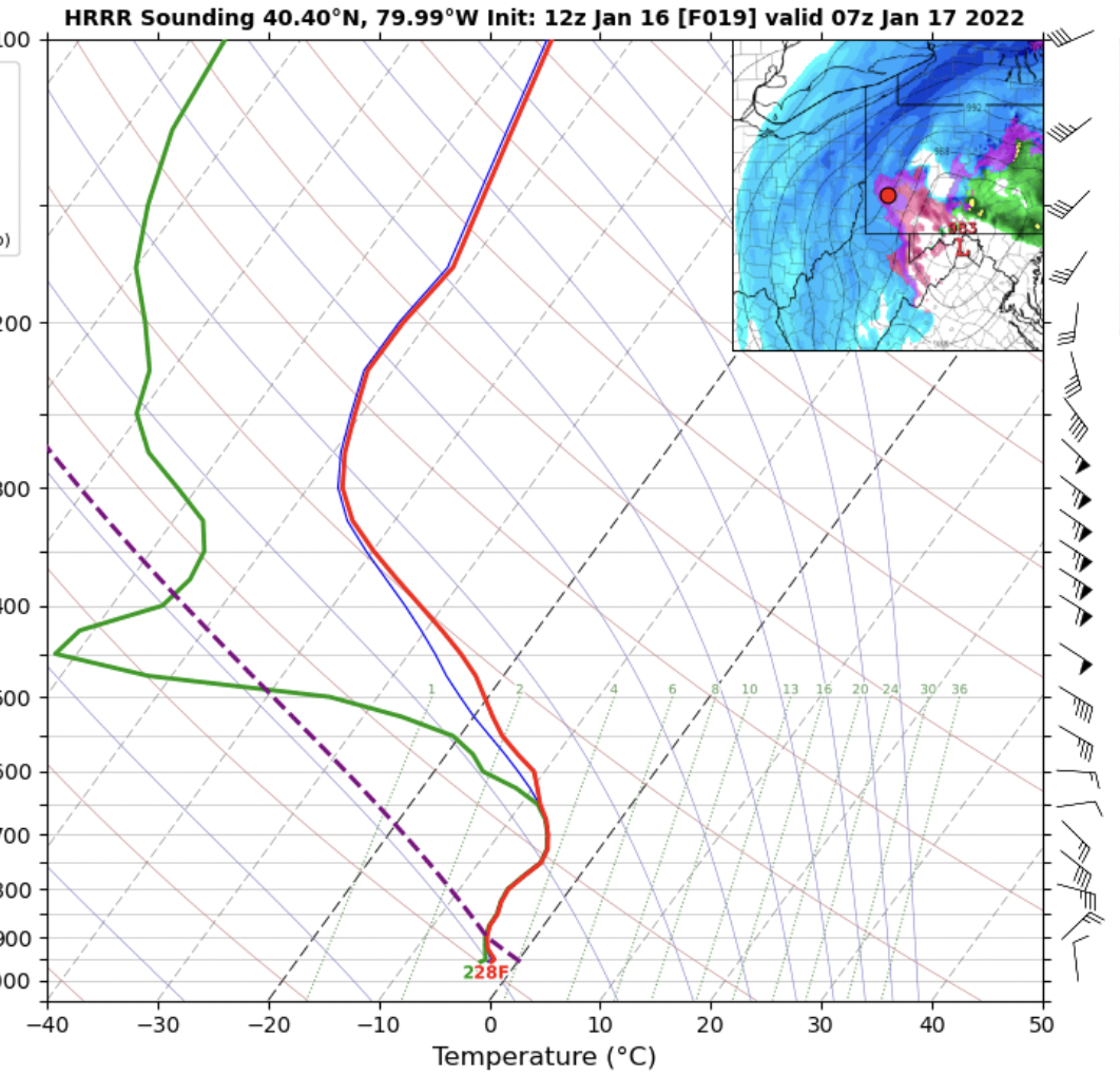
Very possible. Watch the HRRR from hr 14-23. It starts west, tries to transfer to the east, and then goes back west. IF it doesnt go back west. We might get the death band
-
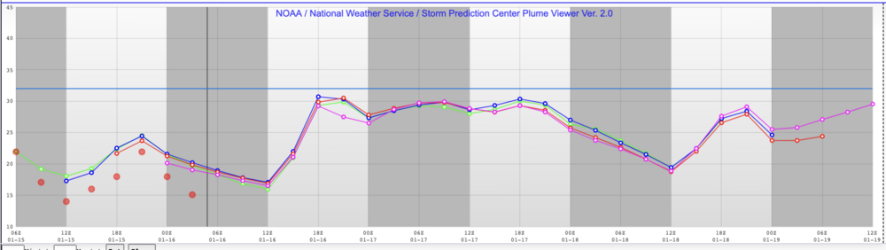
13" through hr 27
-
1
-
-
2 minutes ago, TimB84 said:
Looks like it mixes for a bit after it fills in.
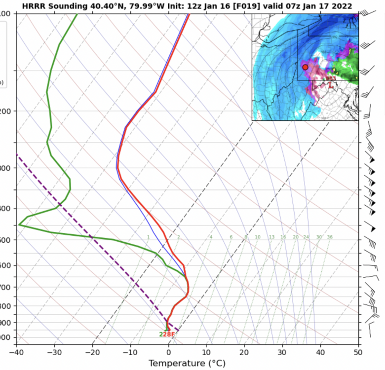
not sure why it is showing that mix. No signs of mixing on the sounding at that point.
-
Just now, TimB84 said:
Fills back in by 6z.
Yea its a pretty brief dryslot. Fills back in real quick
-
welp. That is quite the dry slot
-
Final thoughts on the night because we are all up for a long one tomorrow.
We are in a really good spot. 10-12+ is on the table for sure. Good trends today and we can still see a shift tomorrow. 50 miles to the east and we might be in the bingo zone of 12-15 or more.
It's all there for us to enjoy now.
See ya tomorrow. Dream of snow.

-
2
-
-
UKie is good too.
.thumb.png.a218e1d05471a15ec8c779d3f9d87406.png)
-
Actual 850 wind speeds. The actual speeds are showing 35kts where 55kts was forecasted.
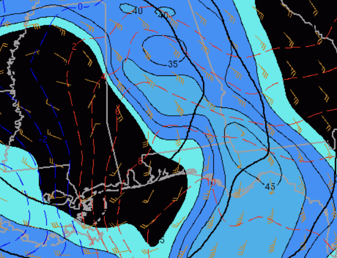
Less windspeed at the 850 = less wind to push the warm air in.
Sorry about the multiple posts. I tried to fit all of the graphics in one post. I couldnt do it.
Overall point- there is some differences in the NAM 3K from the actual meso analysis in some key factors that i think will play an impact on our storm...
Just some food for thought
-
Second, the wind speed is not as strong as modeled. This can all change when the storm gets going in a few hours, but right now, the winds are less than forecasted. This could impact the amount of warm air aloft that gets pushed in. Less jet speed, less warm air.
Forecasted 4z

-
4 minutes ago, Ruin said:
Could you say that the cold air has snuck down a little farther south
Also worth noting. Again, these are just some observations. The NAM (3K)which is our furthest west solution is struggle with certain key features only 4 hours off of its run time.
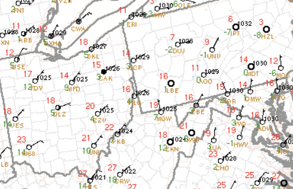
First the temperature. Temps are significantly colder than what the NAM (3K) modeled for 4z.
Forecasted 4z Actual 4z
-
Interesting thing i noticed here. The temps have consistently been lower than forecasted for. Thats a good sign that the cold air is a little more stubborn than the models are predicting. Obviously this is different at 850 than at the surface, but still thought it was interesting to see the temps are starting colder than forecasted
-
Just now, Rd9108 said:
I want the death band
so bad
-
HREF also showed 70% odd of seeing 1"/hr rates from 1am-4 am. That'll be fun to watch
-
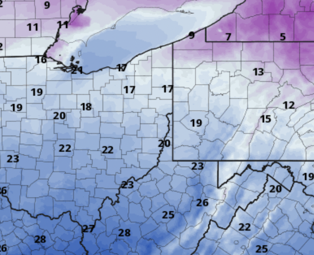
00z HREF looks good too. 10-12" for AGC. Heaviest right on the board of PA/OH. In line with everything else.
-
Just now, Mailman said:
We shall see.
Damn... That deform band lined up in eastern ohio. Man, how sweet would that be.
Looks like most models have set that deform band a little further west than the metro area. Could totally see it moving a little east, but we will see.
For the record, I would absolutely take 15+
-
GFS looks to take a very similar path to HRRR but the deform band is about 50 miles further west.
-
2 minutes ago, KPITSnow said:
Actually, the NAM is still pretty bad. Amazingly it has the best snows almost out in freaking dayton OH, and going through Youngstown and Cleveland.
It's absurd there could be a 200 mile difference between the HRRR and NAM. Luckily the NAM is massively on its own.
Hi Res NAM and HRRR probably only 50 miles different on that big band of snow
-
Lol, how much does that say? We are literally the bullseye.
14+
. -
-
HRRR goes boom.
Great start to the 00z
. -
5 minutes ago, Rd9108 said:
now casting time will be huge.
Love nowcasting.
Community moment -> I love nowcasting with you guys

-
Just now, KPITSnow said:
50 miles south east, we are looking at 15 inches, and that really isn't an exaggeration.
not at all. And most of the other models already have us there.
-
1
-
-
Just now, Mailman said:

-
1
-
.png.12e65047082fdbf7b43d7aac88f0c7c7.png)


Western PA/Pittsburgh Winter 2021/22 Discussion
in Upstate New York/Pennsylvania
Posted
how long have we been tracking this storm?