MikeB_01
-
Posts
2,122 -
Joined
-
Last visited
Content Type
Profiles
Blogs
Forums
American Weather
Media Demo
Store
Gallery
Everything posted by MikeB_01
-

Pittsburgh/Western PA WINTER ‘25/‘26
MikeB_01 replied to Burghblizz's topic in Upstate New York/Pennsylvania
Had a nice burst over by cool springs this evening around 7. Roads got a little slick quickly. . -
Pittsburgh/Western PA WINTER ‘25/‘26
MikeB_01 replied to Burghblizz's topic in Upstate New York/Pennsylvania
coming down good right now -
Pittsburgh/Western PA WINTER ‘25/‘26
MikeB_01 replied to Burghblizz's topic in Upstate New York/Pennsylvania
It will fill in. I think we will still pull an inch. However, I'm not going to fret if i get .75" instead of 1.5". This ones been trending down all week. If anything, I'll just enjoy the snow falling consistently out there. -
Pittsburgh/Western PA WINTER ‘25/‘26
MikeB_01 replied to Burghblizz's topic in Upstate New York/Pennsylvania
Wasn't there a day in early decemeber where a thin snow band dropped several inches along the southern AGC border, but totally whiffed in other parts of the county? -- might explain at lease some of it? -
Pittsburgh/Western PA WINTER ‘25/‘26
MikeB_01 replied to Burghblizz's topic in Upstate New York/Pennsylvania
At this point, even if it falls below, this is season has exceeded my expectations and has been fun. -
Pittsburgh/Western PA WINTER ‘25/‘26
MikeB_01 replied to Burghblizz's topic in Upstate New York/Pennsylvania
10 days haha Here we go again. Time to reel in another big one -
Pittsburgh/Western PA WINTER ‘25/‘26
MikeB_01 replied to Burghblizz's topic in Upstate New York/Pennsylvania
Looks like that clipper will give us a little refresher on the snow pack, but its not super impressive. NWS's high end amount for most of AGC and most of the area is 3". -
Pittsburgh/Western PA WINTER ‘25/‘26
MikeB_01 replied to Burghblizz's topic in Upstate New York/Pennsylvania
I havent looked yet, but im interested to see if the 12z euro hops on for sunday. It didnt have anything in the 6z run, but it looked like the 500 vorticity was starting to find some energy sunday afternoon -
Pittsburgh/Western PA WINTER ‘25/‘26
MikeB_01 replied to Burghblizz's topic in Upstate New York/Pennsylvania
Nam has the tues/wed system well to our south for us to see any flakes -
Pittsburgh/Western PA WINTER ‘25/‘26
MikeB_01 replied to Burghblizz's topic in Upstate New York/Pennsylvania
i was thinking the same thing this morning. I am done with it. I can't handle this cold for this long. To my core, im a warm weather guy. I love the snow, but i'll take summer 365 -
Pittsburgh/Western PA WINTER ‘25/‘26
MikeB_01 replied to Burghblizz's topic in Upstate New York/Pennsylvania
Made it down to 1° in the backyard. Already up to 9° and with some pixie snow out there . -
Central PA Winter 25/26 Discussion and Obs
MikeB_01 replied to MAG5035's topic in Upstate New York/Pennsylvania
-12° from my station in Bethel Park. Early this morning, KPIT set a record and was the coldest temp reached since 1994 at -11°. . -
Pittsburgh/Western PA WINTER ‘25/‘26
MikeB_01 replied to Burghblizz's topic in Upstate New York/Pennsylvania
-12 imby this morning. Crazy to see the temps across the area -
Pittsburgh/Western PA WINTER ‘25/‘26
MikeB_01 replied to Burghblizz's topic in Upstate New York/Pennsylvania
Driving home tonight, I saw a -7° on the car thermometer. Brrrrr . -
Pittsburgh/Western PA WINTER ‘25/‘26
MikeB_01 replied to Burghblizz's topic in Upstate New York/Pennsylvania
will be fascinating to see if this verifies. Props to whoever had "gulf effect snow" on their bingo card -
Pittsburgh/Western PA WINTER ‘25/‘26
MikeB_01 replied to Burghblizz's topic in Upstate New York/Pennsylvania
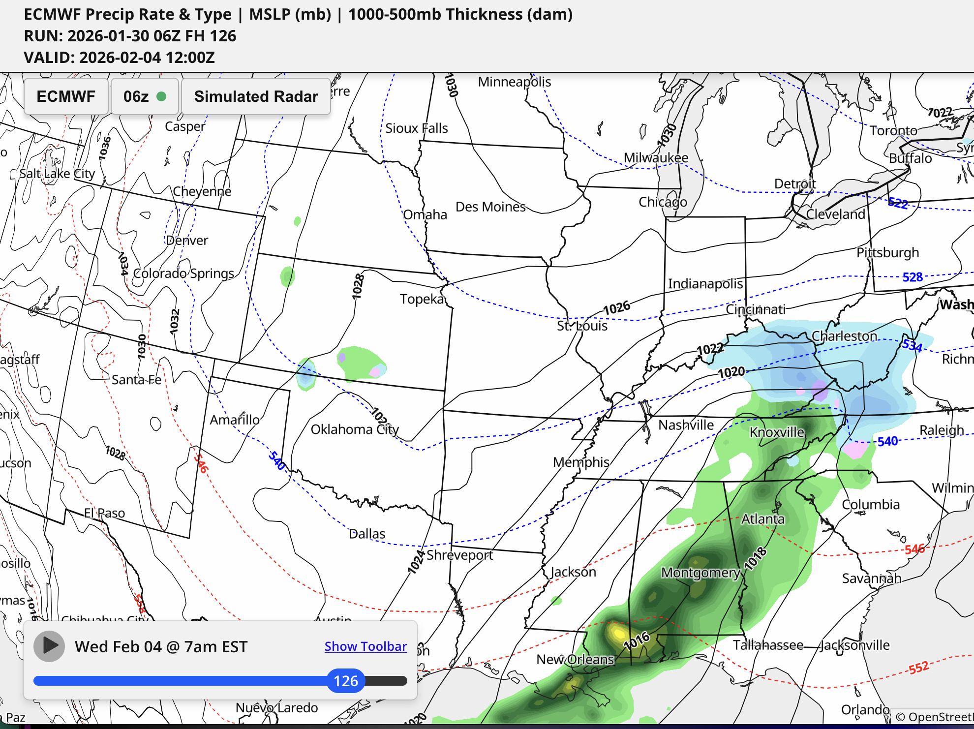
just an FYI - There is a new weather modeling site that i found that is pretty nice. Custom zooms, decent selection of maps, and nice graphics. Its called https://synopticwx.com/ I believe it will eventually cost money for access, but it is in Beta right now and free to sign up. Here is what the 06z Euro showed for our wednesday system
-
Pittsburgh/Western PA WINTER ‘25/‘26
MikeB_01 replied to Burghblizz's topic in Upstate New York/Pennsylvania
Honestly, 15 and no wind chill yesterday felt balmy . -
Pittsburgh/Western PA WINTER ‘25/‘26
MikeB_01 replied to Burghblizz's topic in Upstate New York/Pennsylvania
-6 imby . -
Pittsburgh/Western PA WINTER ‘25/‘26
MikeB_01 replied to Burghblizz's topic in Upstate New York/Pennsylvania
looking better on the GEFS as well. -
Pittsburgh/Western PA WINTER ‘25/‘26
MikeB_01 replied to Burghblizz's topic in Upstate New York/Pennsylvania
00z GFS... Its still there for next Wednesday -
Pittsburgh/Western PA WINTER ‘25/‘26
MikeB_01 replied to Burghblizz's topic in Upstate New York/Pennsylvania
only made it to 6° imby. But im not sure i have the thermometer in the best place for accuracy. 3° was the official at kpit -
Pittsburgh/Western PA WINTER ‘25/‘26
MikeB_01 replied to Burghblizz's topic in Upstate New York/Pennsylvania
Ensembles continue to show high confidence in a Nor`easter developing this weekend off the eastern seaboard as a digging eastern trough invokes cyclogenesis Saturday into Sunday. What we are still uncertain of is the exact track of the low tied to the timing of (or if) the upper low closes off from the flow. The snowiest scenario is one in which the low closes early is deeper. There is really only one cluster representing 25% of guidance at this point that allows for this to happen. Should it occur, probabilities of snow are mostly confined to the high terrain of West Virginia (60% chance of >1", 30% chance of >3", 10% chance of >6"). 75% of guidance has the low closing too late (and too east) or not deep enough to suggest much appreciable snow accumulation in the forecast area at this time. -
Pittsburgh/Western PA WINTER ‘25/‘26
MikeB_01 replied to Burghblizz's topic in Upstate New York/Pennsylvania
i thought i was crazy when i didnt see anything with reflectivity but could see if snowing outside. I did a little research and figured out that sometimes correlation coefficient sniffs out these low level pixie dust snows. Just thought that was pretty cool -
Pittsburgh/Western PA WINTER ‘25/‘26
MikeB_01 replied to Burghblizz's topic in Upstate New York/Pennsylvania
see... i'm not crazy lol -
Pittsburgh/Western PA WINTER ‘25/‘26
MikeB_01 replied to Burghblizz's topic in Upstate New York/Pennsylvania
Pretty positive movement today .