

TullyHeel
-
Posts
12,875 -
Joined
-
Last visited
Content Type
Profiles
Blogs
Forums
American Weather
Media Demo
Store
Gallery
Everything posted by TullyHeel
-
Going to be interesting to see what the models do today. It looked like they were coming into agreement until the Euro went south again last night. Looks like the NHC track stayed the same, though.
-
So, the GFS comes in line with the Euro, and then the Euro goes further south into SC. Madness.
-
Pretty much the worst possible track for me.
-
Fran had gusts up to 79 mph here. I am assuming with Flo being a cat 4 that we could have even bigger gusts than with Fran.
-
Yeah, only thing that would save NC is if the models are wrong and Flo goes west longer. Of course, that is bad for SC.
-
And looks like it could be the worst case scenario for the Triangle.
-
Hoping it does weaken fast once it comes inland. Looks like the NHC has it down to 70mph now instead of 100 mph like before once it comes inland.
-
Keep hoping this turns and goes out to sea, or it never gets to a big hurricane. But this looks really bad for NC.
-
That really makes me sad. My favorite place in NC.
-
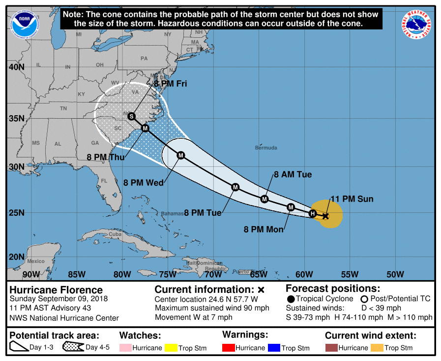
This is getting really scary. Hope she goes out to see, but looks like the tightest clusters from the model runs are between Charleston and Wilmington for landfall, and at least a cat 4 when it hits. This could be worse than Fran.
-
.png.10cbd1cd56ac6cbb0ccc79f653835f7e.png)
-
Good luck, folks. Looks like you are really under the gun today. The tornadoes in Iowa yesterday weren't even expected.
-
Glad to know jburns is a fan. Calling 3 to 4 for Wake Forest. Book it.
-

The August 21, 2017 Great American Eclipse
TullyHeel replied to ice1972's topic in Weather Forecasting and Discussion
An important eclipse warning for Oregon! -
Hit 84 here today. Like I have always said, if it isn't going to snow might as well be sunny and warm.
-
You don't use sarcasm enough in your posts.
-
This place is way too serious.
-
Wow and the other mets seem to know what they talk about. The typical nervous nellies continue to be negative. Too funny.
-
Nah, either we have snow Saturday or my kids play basketball. Either way it'll be a fun day.
-
Y'all worry too much. Ain't nuthin but a thang.
-
I agree. Euro, GFS, and NAM all showing 9 to 12 for most of Wake, though. Looks like NAM is coming in with possibly more this time. Might have to increase those totals.
-
Winter Weather Watch out from RAH. Going with a general 3 to 5 and the "locally higher amounts possible" line.
-
Awesome model runs overnight and this morning. Really looking like a possible big storm here. I can't believe they blew up the other board and destroyed my thread. WRAL saying some models are still holding out. Huh? Looks like they are all on board to me. Love how the same people always look for everything to go wrong every time. Just enjoy the ride. Whatever happens happens. No big whoop.
-
-
Hard to get a word in with all the nervous nellies posting about everything that could go wrong. It's just snow. Enjoy the ride. Drink it in, man.

