

eduggs
-
Posts
4,770 -
Joined
-
Last visited
Content Type
Profiles
Blogs
Forums
American Weather
Media Demo
Store
Gallery
Posts posted by eduggs
-
-
1 hour ago, WinterWolf said:
Modeling is all over the place…don’t trust anything as others have said. And 18z runs always something crazy….it’s a joke with those. Lol where’s the huge cold shot it had at 12z? Off hr runs are horrible.
The problem is looking beyond 7-10 days. Obviously small initial variations will lead to large model differences at that range.
-
Summerlike dew points. Outside shot of someone hitting 60?
-
 1
1
-
-
3 minutes ago, 40/70 Benchmark said:
Yea, it takes some luck to nail it, but the more skilled forecasters will get "lucky" more often.
I'm skeptical. Show me data to back that up and I'd change my mind. Otherwise to me it's like stock trading. Most people think they are better than random chance. But it's perception over reality.
-
1
-
-
On 1/24/2023 at 9:58 PM, Winterweatherlover said:
I think the RGEM is too warm but if its right it has NYC already in the 40s when precip starts.
23 hours ago, eduggs said:It's probably about right. Something like 41/26 with a 36F wet bulb.
Nailed it
-
18 minutes ago, Brian5671 said:
he's been wrong all winter. that arctic shot into Texas is transient too-in and out and then back to the same ol pattern....
Well anybody forecasting regionally specific weather 10+ days out will either be wrong or lucky.
-
 1
1
-
-
Tough winter so far for the long-range "pattern" sniffers. The 7-10 day period feels like either a Maine or Carolinas jackpot situation. It's hard to see how we thread the needle based on where things stand now. The cold-side snow zones look narrow. Roll the dice and see how it plays out.
-
18 minutes ago, Winterweatherlover said:
I think the RGEM is too warm but if its right it has NYC already in the 40s when precip starts.
It's probably about right. Something like 41/26 with a 36F wet bulb.
-
1 hour ago, donsutherland1 said:
Snow season futility rankings through January 24th.
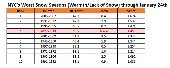
One cold day - December 24 - is basically keeping us out of 2nd place.
-
1
-
-
3 hours ago, Go Kart Mozart said:
And the Koochie....
Not happening. NYC and surrounding suburbs are destined for their 17th consecutive winter rain event without any measurable snowfall by the end of this run.
-
1
-
-
3 minutes ago, TSSN+ said:
You are joking right? Models can’t even get stuff right 72hrs out anymore. We seen huge jumps even inside 3 days.
Stop looking at clown maps. And ask someone who knows what they are talking about. Modeling has been excellent this year. Noticeably better than even 5 years ago. I've been tracking for 30 years and the steady improvements have been noteworthy.
3rd party vendor clown maps, which don't reflect raw model data, exaggerate surface weather and run to run changes. Upper level features are what should be focused on. And this year, mid-range models have time and time again correctly locked onto a particular upper level setup in the 5-7 day range and generally made only minor adjustments thereafter. Consider how few fake fantasy snowstorms we've had inside 168 hours. That was always a feature of previous seasons.
-
2
-
-
Nothing of interest for as far as the models can reasonably see for the 55th day in a row or something like that. I vaguely remember some threats of interest in late November. The mid-range modeling has been really good. Unfortunately that has meant really boring tracking.
-
1
-
-
14 minutes ago, Scraff said:
15” of snow to a rainy fropa in just 6 hours. Man I love the GooFuS!

Obviously surface weather will have huge run to run variability at 200hr. What do you expect? The mid-range models have had an excellent season overall. For the most part there have been very few major head fakes to get our hopes up inside of 5 days. Models have been pretty much locked in after settling onto an outcome in the 5-7 day range. Unfortunately they have correctly locked in on rain storms. Meteorological modeling has improved tremendously over the past 3 decades... and it continues to improve further.
-
3
-
-
3 hours ago, CIK62 said:
Meanwhile back at the Ranch: All this---and 5" of Liquid Equivalent wasted. This is a cool 40degs.(34/46) or +6.

More 50s than 20s during peak-winter. So so weird. That's deep south stuff.
-
1
-
-
1 hour ago, TSSN+ said:
Literally been like the F you Maryland south winter so far. If only this could trend 50-75 miles SE. But it won’t.
Haven't had anything in northern NJ either, outside the far NW hills. Zippo. Actually it's been 2 years of futility locally. So I/we commiserate.
-
1 hour ago, ORH_wxman said:
Weird little blowup of precip
NAM had it. Especially apparent on the 3km. Congrats.
The snow you're seen in the past hour is more than a lot of us to your southwest have seen all winter. We are enjoying it vicariously.
-
1
-
-
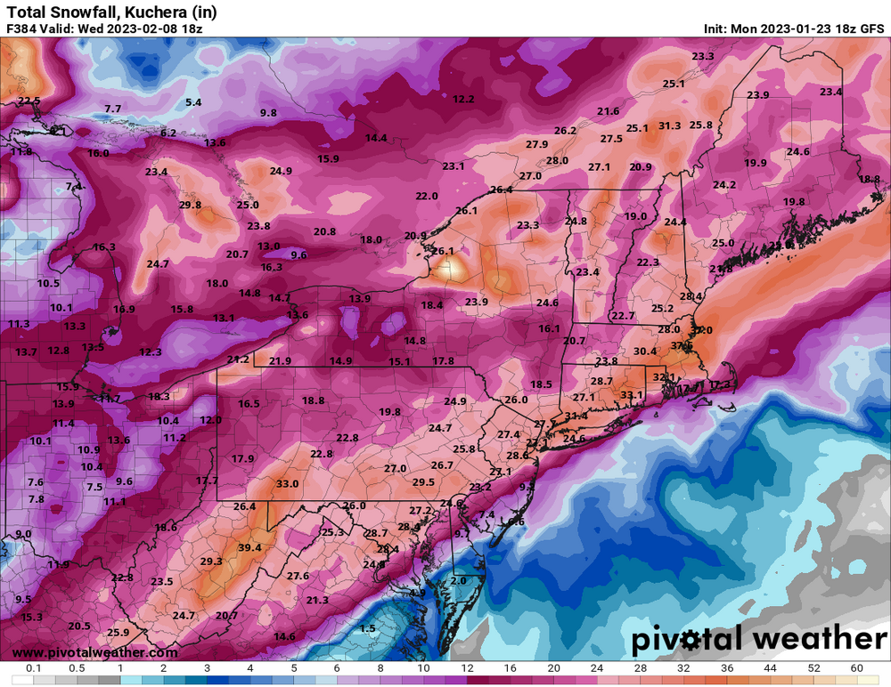
The 12z EC looks most promising for Wed. I has a fortuitously timed slug of overrunning snows before mid-levels become unsupportive. Even with that, the 10 day grand total clown map for NYC shows 2.1" with 10:1... so really a coating to an inch considering surface temps. Just brutal. Peak climo.
-
2 hours ago, HeadInTheClouds said:
I mentioned Catskills because you said elevated far N and W. I don't consider Sussex and Putnam counties far NW from NYC. As far as where the storm will impact the most I agree with everything you said, especially about I-84 corridor Fishkill-Beacon area. Southern Dutchess county definitely could go either way. I think Poughkeepsie on north sees 1-2.
Fair enough. I guess I usually think in terms of regional forums or even network TV viewing areas. Within our forum, I consider the Hudson highlands and NNJ ridgelines to be the elevated N&W. Maybe the Poconos to Shawangunk Ridge to southern Taconics could be considered part of that, as the far N&W.
-
14 minutes ago, HeadInTheClouds said:
Elevated N and W expecting more than a little, Catskills expected to get 5-8. Valleys should also get some snow, anywhere from 1-2 in MHV to 3-6 up towards I90.
I don't consider the Catskills to be part of the NYC area. Yes the Catskills are N&W, but so are the Adirondacks. I was referring to more like Sussex County NJ or Orange and Putnam, NY.
This storm looks to be for Wayne, Pike Cos. PA to Sullivan, Ulster, Greene, Columbia Cos. NY, to the Taconics and Berks etc... Dutchess could have a significant gradient I think... with a 0-2" low along the Beacon waterfront to a max somewhere along the NE corner in the Taconics.
-
5
-
-
Glimmer of hope yesterday and then it's all gone to shit today. Maybe elevated far N&W get a little front- and backside love like Walt describes. Could even be some wet snowflakes mixing in to the coast tomorrow at the end. Basically April. And no excitement for a cutter with a SLP to Ottawa and rain to Canada. Nothing of note in the pipeline until fantasy land. The long range looks slightly different than it's been but not particularly favorable. It's too far out to take seriously anyway. Low point of the winter for me morale-wise. We can almost see the end now.
-
26 minutes ago, Winterweatherlover said:
The 18Z GFS would be the best case scenario for both storms, right now it has no support so I'd lean toss.
Some support. 18z HRRR. Also the 18z RGEM shifted in that direction. SNE likely to benefit the most. But I'm starting to believe elevated NWNJ through SENY might sneak a few inches on the back side. Elevation looks like it will help as lower boundary levels look slow to cool.
-
11 minutes ago, Typhoon Tip said:
Know what's interesting I didn't know this thread existed first of all - I would have posted those thoughts here. Not that anyways needs to care, ha
But, I was elaborating how the models have been inching SE with the rain/snow axis, as this system has both been nearing in time, but also tending to weaken and flatten out.. (by weaken ..I don't mean losing identity altogether, I just mean lessening warm thrust ending up W..etc).
Anyway, it seems this run of the Euro stopped inching and took a leap of faith. I kind of hate this when this happens... This is sort of where this wants to go, so the Euro shows us that solution - but we cannot allow ourselves confidence enough to toss the others in lieu of this.
The system has been sharpening up slightly early on, and shifting the R/S line in the mid-Atl. NW... then flattening later on to benefit NE. The cause appears to be increasingly disjointed waves/ areas of vorticity. Overall tendency is a weaker storm with energy hanging back. More snow for places that have been receiving a little of it lately.
-
1
-
-
2 hours ago, Stormlover74 said:
The difference is the cold doesn't disappear in the long range like it had been showing. It reloads for early Feb but who knows at this point if it'll be right
That's already happened numerous times since late Nov. in the long range. All models have been biased too cold in the east and too warm in the west. Until cold gets inside of 7 days on multiple models for a few runs in a row, I will doubt it.
-
2
-
-
42 minutes ago, MJO812 said:
Like the gfs
Daytime highs, nighttime (high) lows, days with rain, total rain all probably near winter-to-date records. Coastal plane snowfall throughout the area near record lows.
I see no reason to expect that to chance anytime soon. The same features keep popping up around 7 days out and then basically holding. Still hoping for positive changes though.
-
58 minutes ago, snowman19 said:
The NAM has done a full cave to what the RGEM has had run after run for days now, for tomorrow. That model is wretched. NWS should just shut it down, useless
Overall I think most short and mid-range models have done a great job this winter. Obviously they are all suspicious out at the end of their ranges. But inter-model agreement and run to run consistency has been relatively high IMO this winter. Few big head fakes. The problems have been people taking 10+ day charts and running with them.

January 2023
in New York City Metro
Posted
I'm still very skeptical of this. We're getting a few hits here and then on the odd model run or individual ensemble member. But the CMC and EC are largely unsupportive right now. When there's precipitation temperatures look marginal, especially for urban areas. As soon as it's cold enough it may be hard to get precipitation to our latitude until after the height field resets. Then it's likely back to cutter city.