

eduggs
-
Posts
5,133 -
Joined
-
Last visited
Content Type
Profiles
Blogs
Forums
American Weather
Media Demo
Store
Gallery
Posts posted by eduggs
-
-
Could be a pretty sharp cutoff. I'm cautiously optimistic for Monmouth County, NJ across to the southern shore of LI. But I'm not too excited for NENJ to Rockland Co. NY. NYC right on the boundary between plowable and nuisance.
-
 2
2
-
-
51 minutes ago, EastonSN+ said:
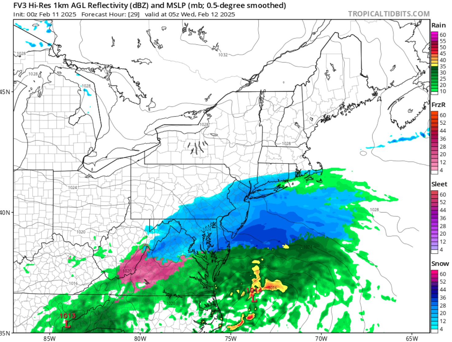
Just for educational purposes this is not a cutter LOL. It's not an inland runner either. I wouldn't even call it a coastal hugger. This depiction, and it's only one mile depiction so it can change a million times, is of an inside the benchmark track. Those give more snow than a coastal hugger but do change to ice and rain occasionally as it is inside the benchmark. I would take this in a heartbeat as you would get a good thump to start.
The 850mb low track is more critical than the SLP. The 850mb low tracks inland along the east coast until it reaches near NYC. This is the reason eastern coastal areas briefly go to a mix or rain on that depiction.
-
1
-
 1
1
-
-
1 hour ago, brooklynwx99 said:
lol no model shows a cutter. could it get a little too close for comfort for the immediate coast, sure, but i find it highly unlikely that we see a system cut through the Apps. more likely to see suppression than a wet outcome here
The 0z EPS included only a few members with SLP that tracked west of us. A few more that tracked close enough to mix, and the majority with an ideal track or east. None would be considered cutters. GEFS has only 1 close pass. All options are still viable at this range, but a miss east has to be considered the more likely outcome at this juncture.
-
3
-
-
19 minutes ago, MJO812 said:
Fv3 has nothing for NYC lol

It's light - maybe a tenth, but not 0.
-
3
-
-
7 minutes ago, brooklynwx99 said:
the block for Feb 2024 was tenuous and it never really formed. late Feb 2023 was in March, so it could have delivered, but it was too warm. and I don't recall March 2022
this time, the block is going to form and retrograde in an ideal location. just need to iron out the details
Everything always looks clear in foresight. And then in hindsight we can see what went wrong: block in wrong location, too warm, southeast ridge too strong, western ridge not amplified enough etc.
If only we could see exactly how things would evolve over the next 10 days. Then we would know exactly when to get excited.
-
2
-
-
1 hour ago, dendrite said:
Look at those dews
Isolated severe?
-
-
32 minutes ago, brooklynwx99 said:
if this isn't anything but a highly favorable setup on the EPS then some of you are being a bit dishonest. everything is in the right spot with the decaying block over central Canada linking up with the developing +PNA
We'll see how it looks this weekend. Fingers crossed.
-
2
-
-
This week has really gone to shit snow wise. Now that I've reconciled and accepted that, any positive trend or positive bust will feel glorious.
-
1
-
-
My wife and I finally made it to Bolton to explore the backcountry network this past weekend. It's a wonderful thing they have created up there and the people in the NBC are really nice.
The snow conditions and weather were great on Saturday. But I was not expecting a super-highway in place of a traditional skin track. We did several laps to the most distant areas on the map we could find and found loads of skiers everywhere. We found a few places where you could make two or three really nice powder turns, but most areas we found were heavily tracked out. Most of the glade areas funnel skiers to relatively narrow spaces so it's difficult to spread people out. Requiring skinners to stay on trail also creates long queues that feel more like in-bounds hiking than tranquil backcountry ski touring.
What I learned (or rather confirmed) is that 1) the area is doing very well snow-wise this winter and 2) you really have to avoid weekends if you can. It's probably also really helpful to venture out with locals who know the area extremely well.
It met numerous beginner ski tourers... lots of families with kids, which is really encouraging to see. Also checked out in-bounds Bolton and Sugarbush and holy moly is it crowded up there. What a circus.
-
1
-
-
22 minutes ago, SnowGoose69 said:
We were not going to see a real blockbuster potential til post 2/17 or so when the PNA goes positive.
I don't know how you can say that considering the sea of WSWs posted just south of our area. Even a weak shortwave... just a minor kink in the longwave flow... could have shifted the Tuesday event far enough north for a moderate snowstorm. My bar for "high-end" is relatively low. I'm talking 6" of non-mixing snow. Not a blockbuster. You are talking with the clarity of hindsight. We cannot definitively see threat magnitudes more than a week in advance. We can only really talk about likelihoods. Yes a favorable PNA trof is helpful for large events. But it is not required.
-
1
-
 3
3
-
-
Nothing high-end to track through this period. Thump still on track for Wed night. But big threats mostly fizzled. Same story since 2021 I believe.
-
1
-
-
Just now, EastonSN+ said:
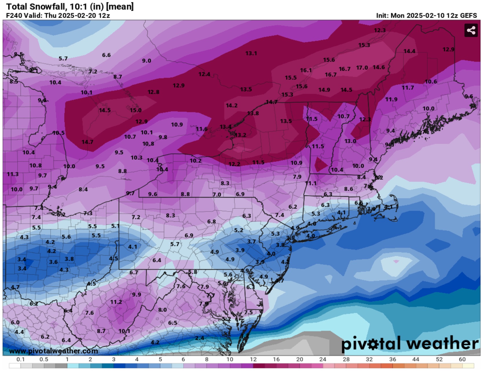
At least they look pretty good for Central Park they had 11.5 on the mean in Central Park is at 4.1. let's see if they get close.
There were dozens of GFS ensemble runs last week that showed a range of mean 10-day snowfall totals for NYC... something like 6-15". As was pointed out multiple times, the 10-day total included a parade of mostly minor events. Some areas are running a little ahead of the multi-day ensemble consensus and other areas a little behind. What's missing is the 6" snowstorm as the cherry on top.
-
1
-
-
4 minutes ago, NEG NAO said:
to be fair it was correct to downplay the storm in some areas like us folks here in Central NJ but other folks to the north and east had more snow - I think we got caught in the system primary to secondary transfer zone here in central NJ and others to the east got the full effect from the developing low that transferred to the coast and also the system was moving fast to the east
I neither downplayed nor hyped this event. Since I was out of the area, in an effort not to get emotionally drawn in, I largely ignored it.
There were local winners and losers for sure, as often happens. The Hudson Valley from Orange/Putnam all the way to Albany didn't do as well as some modeling indicated. PA didn't get much. But LI did really well. It was a short-duration, high intensity event... which can be quite enjoyable. High impact despite modest snow accumulations.
-
1
-
-
For Thurs, it actually helps that the shortwave has sharpened and trended so far northwest since it puts the main surge of warm air into OH and WPA and leaves plenty of room for CAD. The energy is kind of split with some heading up into Ontario and another area of nice vorticity and UVV sliding through our area Wed night. With a different evolution this might have been a significant snowstorm. As is, it could be a solid plowable (thump) event similar to Sat night, but with the local maxes possibly shifted around somewhat.
-
2
-
-
1 minute ago, MJO812 said:
You downplayed last storm and many places for 3-5. Take 1 storm at at a time.
Actually I don't believe I commented on last storm since I was away for it. I was focused on the one before and the one after. Locally we got about 2" and then ice early Sunday. It's a glacier. Looks nothing like the north country where even northern fringe areas got several inches of perfect fluffy powder. From reports it looks like LI and CT did well on Sunday.
-
1
-
-
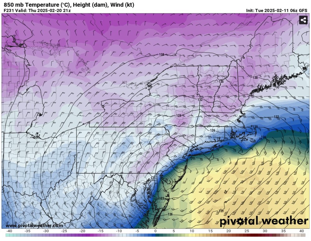
A sharp shortwave over Lake Huron with associated intense SLP on Thursday is not what we had in mind last week when the wave of threats was coming into mid-range view. The feared scenario looks to be playing out. Hopefully southern areas can score a little Tue and northern areas Thurs. Unfortunately any snow looks to take place primarily at night and ends as the all-too-familiar ice to rain. Bummer.
-
2
-
-
9 minutes ago, psuhoffman said:
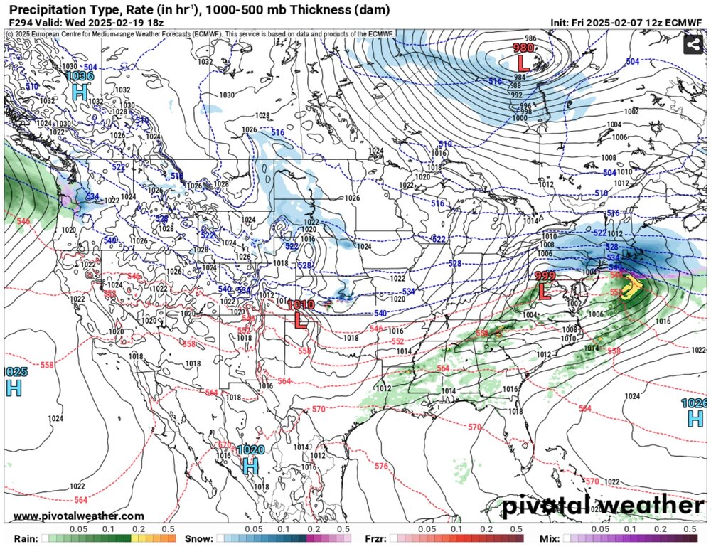
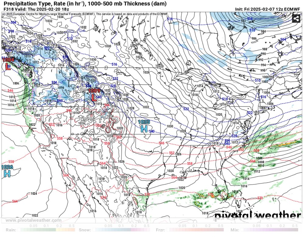
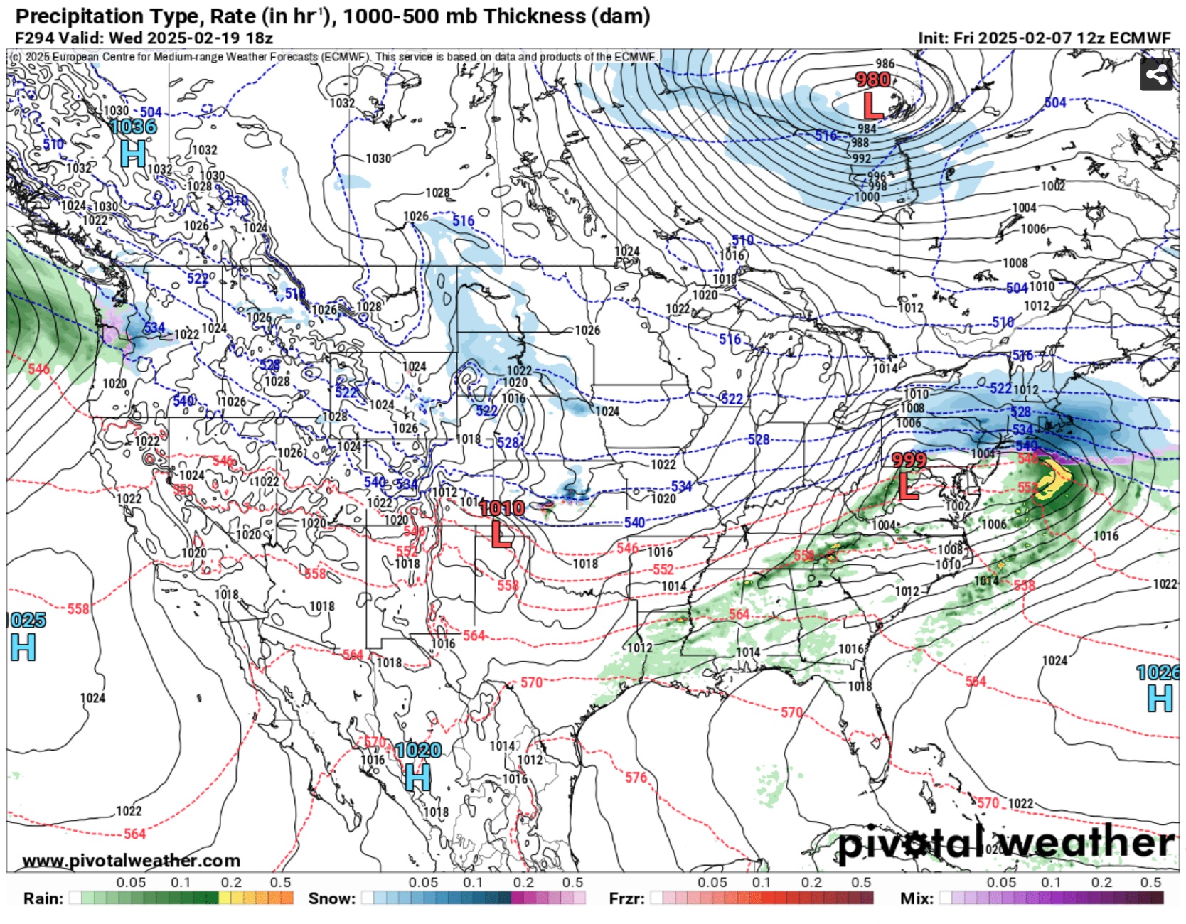
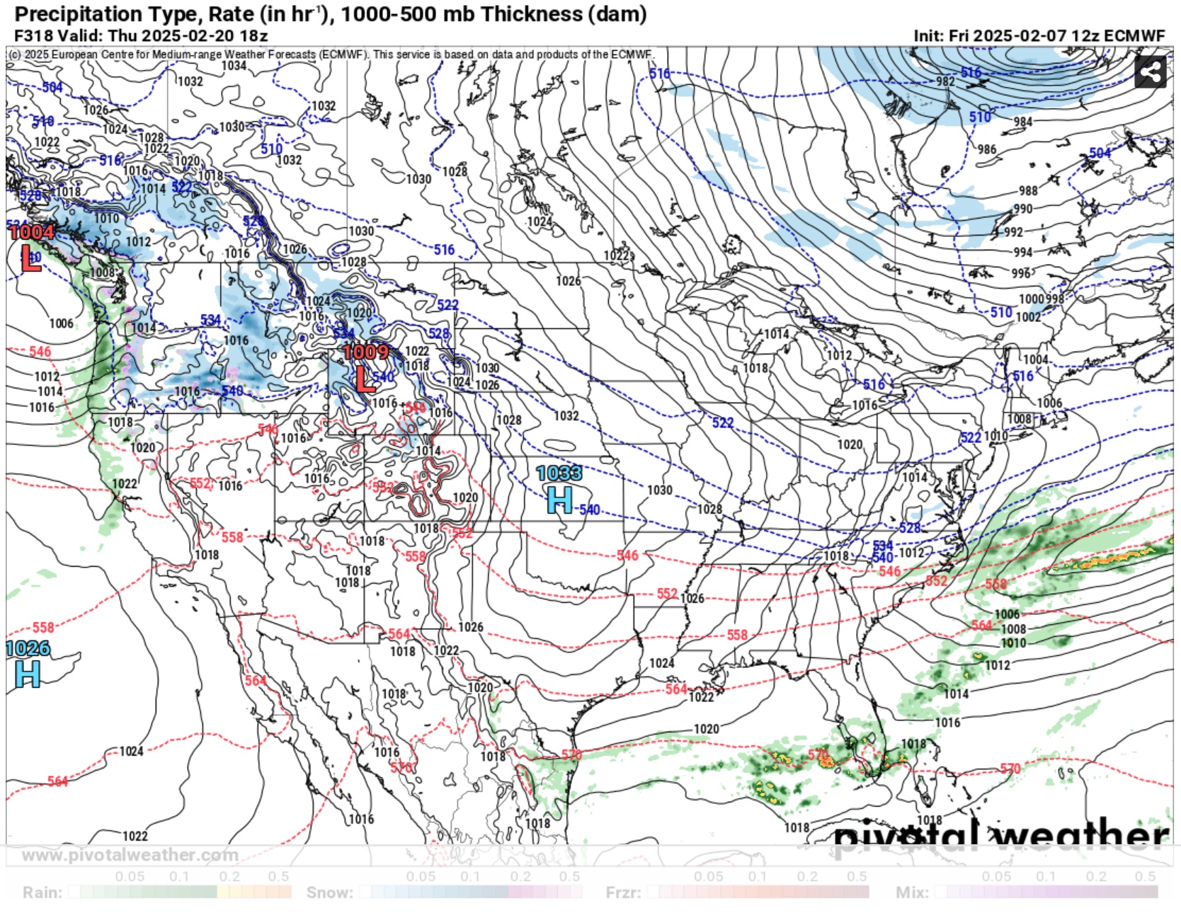
This is hard to get when people are hyper focused on their yard but the bitter truth is with our current level of technology and scientific understanding we don’t have the ability to differentiate between those two outcomes at that range. The difference is noise with minor changes that we can’t account for in initialization leading to those rather major differences that far out.
Those images are actually two time period snapshots in succession in the 12z ECM run around Feb 20th. I just posted them to illustrate that what looks good on 288hr ensemble averaged anomaly chart could easily fail to result in a snowy outcome. In fact it's more likely than not. The shortwave details will determine the result. It sounds like you are saying kind of the same thing.
-
1 minute ago, MJO812 said:

It looks like it did for yesterday morning's event... at least when it was outside 12 hours.
-
1
-
-
1 hour ago, Heisy said:
20th def has me intrigued. Block is formed, solid confluence, 50/50….
Goody, maybe this is what we get:
OR
Many possibilities for sensible weather outcomes...
-
9 minutes ago, Allsnow said:
Did I miss the ice storm?
Who said anything about an ice STORM?
-
If it snows in an unfavorable pattern and rains in a favorable pattern, what does favorable pattern mean?
-
1
-
 1
1
-
1
-
-
1 minute ago, MJO812 said:
Jeez some of you are just miserable. We are not even in the favorable pattern yet.
I was not aware that the weather gods made such definitive proclamations.
-
4
-
-
It could still work out favorably. If the Tue shortwave turns out slightly sharper and surface temps stay at or below freezing, that's a moderate snowstorm right there. Possibly even with an enjoyable, partly daytime, real-snowstorm feel.
If the follow up shortwave turns out slightly flatter, there is a very real possibility of another moderate snowstorm or snow to ice. This event could even turn out to have more QPF. Two significant events within two days is rare. In fact it's conceivable it goes something like 2" - 4" - 4" over 6 days including Sunday.
And there's yet another wave lurking towards the LR.
If forced to guess right now, I'd go with: Tue ends up a light event - C-2. And Thur. is ice to heavy rain. But the ICON 24+hr snow scenario is not off the table either.
-
1
-
February 2025
in New York City Metro
Posted
It's too early to give up on next week. Plenty of hope on ensembles still. Even Saturday could end up snowy.