

eduggs
-
Posts
4,770 -
Joined
-
Last visited
Content Type
Profiles
Blogs
Forums
American Weather
Media Demo
Store
Gallery
Posts posted by eduggs
-
-
CMC is northern stream dominant. That feature has to be way out ahead or flat. Only NNE can cash in with a surface low anywhere near the Lakes.
-
Detroit - Rochester SLP primary track on the 12z GFS is not what most want.
-
15 minutes ago, MJO812 said:
Icon flatter
Keep that primary slp south and east of PA and it's game on for all of NNE and possibly further south. As many have noted, the key is to avoid an early phase.
-
 1
1
-
-
5 minutes ago, dryslot said:
I don't think we want a full or even a partial phase for this next one right now.
Definitely not at day 4 in the Midwest. But a subsequent phasing of a follow up polar wave when the main low has traversed further east could work out.
-
1 hour ago, dryslot said:
The spread has tighten some, At least its starting to have some grouping and not looking like bird shot from the last couple days.

I think what happens days 4-5 with the initial wave interaction and slp track through the midwest is actually more important than where the low center is at day 6.
-
15 minutes ago, donsutherland1 said:
From the site: “The aerial distribution of snowfall and population information are combined in an equation that calculates a NESIS score…”
The score may yet be adjusted.
I think that storm broke the algorithm. 8 day storm? Pretty generous 4" coverage on the southern periphery. Getting the NYC to Trenton corridor in that areal coverage also probably helps the score. I guess technically a T is < 4"
-
1
-
-
8 hours ago, TauntonBlizzard2013 said:
We are lacking several key ingredients, including a fresh cold source.
Actually I would say there is a potential cold source to our north on Thursday. But the early wave phasing and slp through the midwest pushes it out of the northeast and deep into Canada.
-
1
-
-
5 minutes ago, MJO812 said:
I'm still going to bed and waking up early to see If the models become favorable lol
The amplifying and severely negatively tilting trof that's modeled is fun to look at. There's actually a little cold air to our north to work with initially, and this is still 6 days out. So I keep checking too.
Problem is all guidance is showing a relatively early phase in the midwest, which quickly scours out the cold throughout the northeast. That means even if a developing coastal slp goes ballistic, there's no available source nearby to tap into.
We need to hope for a re-jumbling of the features that shakes out more favorably. 1st goal is to lock in more cold air.
-
The 0z CMC and even EC are incredible. Days and days of rain beginning next weekend. Presumably coastal flooding too. Most northeast ski areas would probably have to shut down. Peak winter climo season.
-
3
-
-
5 hours ago, Rjay said:
Yup. Bluewave is 100% right that we need to get a decent pattern modeled inside 10 days. The models continually underestimate the pac jet.
I think we need a snowstorm modeled inside 3 days, not a "pattern." To the degree that patterns can even be defined, they are continental to hemispheric in scale. Snowstorms are local to regional.
-
1
-
-
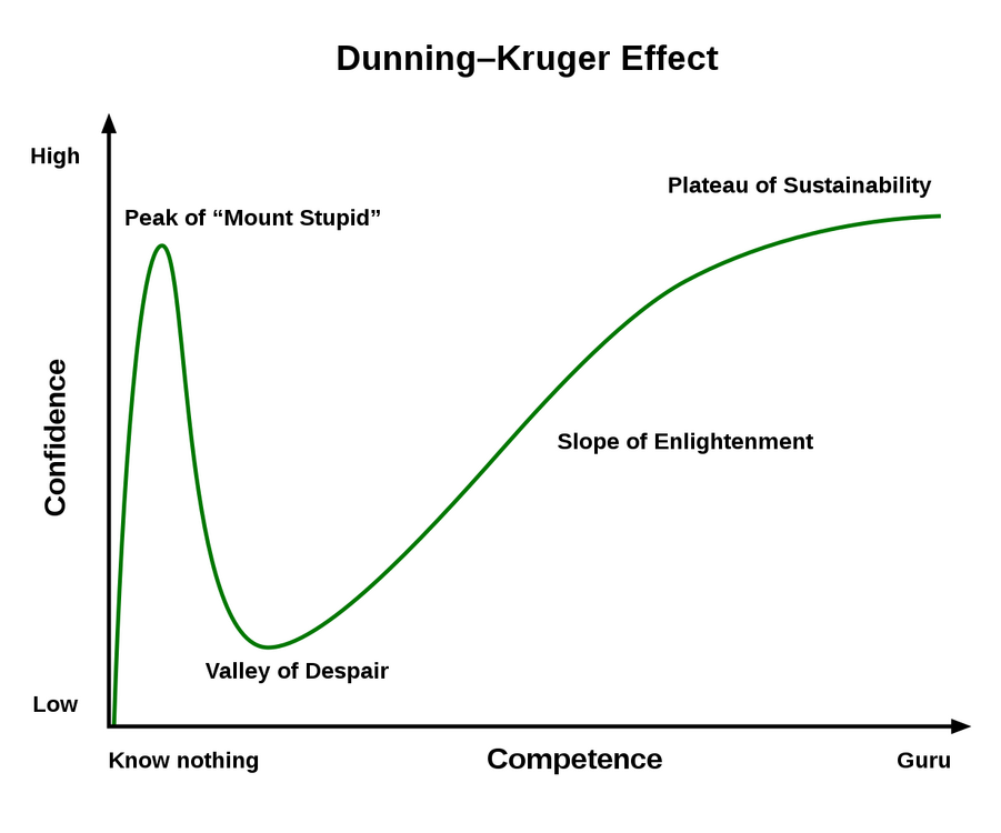
The Dunning-Kruger effect neatly illustrates so much of what we observe both in life and on this board.
-
 6
6
-
-
2 hours ago, brooklynwx99 said:
the pattern will flip around the 10th as the ULL off the WC retrogrades westward towards the Aleutians when the Pacific jet retracts
this is well agreed upon by ensembles and it makes sense, so this is a break more than anything else. the hints of Scandinavian ridging also point towards renewed blocking once into the last couple weeks of the month. the -EPO/+PNA would also scour out any residual Pacific air relatively quickly, so there wouldn't be a week or two of delay, especially under peak climo
Careful about using those 10+ day ensembles. Any "signal" that you see out in that range should be treated with skepticism. It's fine to interpret what current model guidance is showing. But it should be well understood that those features have a good likelihood of verifying significantly differently than currently modeled.
-
3
-
-
That said, I could see the early next week wave turning into a minor event. The wave spacing at least on the GFS and NAM has improved. I'm leaning against it because there haven't even been many individual ensemble members that have bitten, much less an OP run. But we do have a snow supporting atmosphere plus an upper level wave.
-
1
-
-
I'm not sure I've ever seen the 10 day charts look this terrible this time of year on every model. 573dm at 500mb for days and days and days. It looks like June. There's not really even anything to root for except maybe record breaking warmth. We'd need some kind of massive multimodel error just to make it interesting.
-
1
-
-
1 hour ago, Brian5671 said:
Agree 100%. Analogs from colder period don't carry as much weight either....
The problem is using analogs to predict local weather. Yes the climate is steadily changing, but that's not what happened here.
-
5 hours ago, weatherpruf said:
There are plenty of journal articles on these topics. This forum is about the upcoming weather. If you really want to know the answers you can find plenty of good information from legitimate sources online or in your local library. You don't even have to search for them, the librarian will do it for you.
Seconded. A lot of really smart people have researched extensively and continue to research all the gotcha questions in addition to legitimately interesting climate change issues.
-
1
-
-
18 minutes ago, jm1220 said:
It doesn't even look like that big a snowstorm coming up with this late week event anywhere outside the snowbelts. Looks like the trough takes a while to close off and the surface low to deepen enough for a CCB heavy snow shield to form over the Midwest and when it does close off, the low occludes quickly and there's only really heavy snow for parts of Michigan. Our secondary low(s) along the cold front might take some of their moisture/snow away too. Chicago area might just get 3-6".
Reminds me a little of the "convective feedback" area that we screamed at during the 2 January events last winter. This looks a little like that with the waves ahead of the main trough forming secondary lows that in this case hug the coast/go just inland along the cold front and might make our storm worse in terms of heavy rain and winds.
Proximity to the Ocean definitely enhances our snowstorms. The midwest is a little moisture starved, but the ratios will be better than 10-1 in places like Wisconsin. Michigan should do well, especially with some lake enhancement, and even northern IL could do pretty well.
-
1
-
-
Anybody with access to the GEFS individual members care to share the approximate southeastern extent of the ULL amongst the individuals at 18z and 0z. The past few runs have shifted this feature slightly further SE.
-
The Canadian has the day 8 threat.
-
2
-
-
5 minutes ago, brooklynwx99 said:
GFS is quite interesting for early next week... really close here to buckling the trough
obviously, this won't do it this run, but continued amplification of the PNA ridge would allow this to work. something to keep an eye on

I think we just need a slightly different orientation of the height field. If that ULL is slightly less suppressive or a lobe retrogrades west and dives into the trof, that would work.
-
1
-
-
GFS still shifting ever so slightly southeastward at h5. We just need 3 or 4 more like that with no steps backward to make things interesting.
The ICON shifted a little as well but the RGEM appears not to have.
-
1
-
-
Great post Don. You bring so much to these discussions. I think we mostly fail to meet you on your level.
My only quibble with your excellent analysis is the your handling of sample size and its impact on confidence and uncertainty. But I don't even have a good solution for dealing with small sample sizes in weather-related statistics other than a big shrug. Sometimes there just might be too much uncertainty to draw conclusions.
-
2
-
-
24 minutes ago, CoastalWx said:
I’ll sell backside snow there. Maybe a few flurries to end.
I'm with you. It's just funny to look at the raw hourly GFS output and see that unusual weather reversal.
-
It's going to be an interesting and historical moment on Friday when it's 20F and snowing in DCA while it's raining on the summits of Mt. Washington, Mansfield, and Marcy. I think it's happened before, but still rare.


January 2023
in New York City Metro
Posted
It looks like there's a small chance some NYC urban areas won't hit freezing all January. I think we'll get a seasonably cold day or two at least, but it's not a given.