

eduggs
-
Posts
5,949 -
Joined
-
Last visited
Content Type
Profiles
Blogs
Forums
American Weather
Media Demo
Store
Gallery
Everything posted by eduggs
-
I actually think BGM is more likely to mix with sleet than western LI as crazy as that sounds... because of the track of the 700mb low. Otherwise I agree, good map.
-
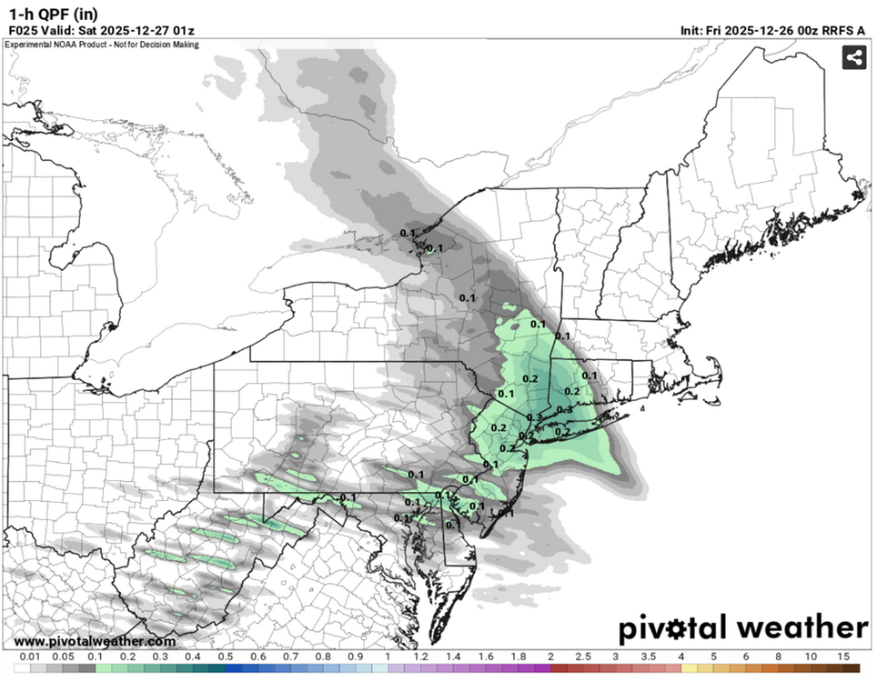
The RRFS has snowfall rates of 2-3" per hour tomorrow night (assuming 10:1). The heavy snow only lasts an hour or two on the model, but it would be fun. Other models have a burst of heavy snow as well though mostly 1-2" per hour max.
-
Real early (probably premature) radar hallucination... but to my eye the radar looks pretty good tonight. Returns are turning sharply southward over Lake Huron and there's already a finger of reflectivity oriented NW to SE situated pretty far west relative to model guidance. Probably doesn't mean much at this point.
-
On the GFS, PHL and EPA has been losing snow and CT, MA, and ENY have been gaining snow.
-
GFS still looks good locally as depicted in terms of QPF. But it definitely shifted northeast with the mid-level lows. It now gets significant snow to ALB and HFD. A day ago they were both on the fringe of the forecasted precip. shield. The HRRR (1z, 2z) also appears to be slowly ticking northeast aloft too. Need that to stop.
-
Those are some hellacious snowfall rates just after 0z on the RGEM. Looks like 2"+ per hour for an hour or two. That would cause some serious problems on the roadways for holiday travelers.
-
The 0z HRRR and NAM had pretty well defined 700mb lows NORTH of Lake Ontario. They keep the circulation alive almost to Ottawa. That's why they push sleet past Binghamton and briefly to Monticello, NY. The GFS has a weaker 700mb low that dissipates more quickly. Hence warm air near 700mb doesn't surge as far northeast, keeping the mixing line much further southwest. We can't know for sure what will happen, but the NAM has a track record with mid-level lows.
-
For what it's worth, the RRFS gets sleet the NJ-NY border, including NYC, after a really good thump. QPF is higher this run, however, and there's likely a little more snow to end.
-
You implied the NAM was wrong regarding snowfall last Tue... Not that posters who misinterpret its output were wrong. But you can't hold misinterpretation against the NAM. I agree with you about this event. The 18z NAM was at or past the outer envelope of ensemble solutions. It also has a tendency to make larger run-to-run changes than other models. That makes its outlier depictions unlikely.
-
I don't think there has been much model flip flopping over the past 48 hours. A few mesos were really suppressed at the end of their ranges initially and the 18z NAM jumped pretty far north. Other than that, most models, esp globals and ensembles, have been pretty consistent. That should lend confidence. And in fact it does. The problem is there have been plenty of cases in the past where a late shift in a model (often the NAM) heralded a true shift in outcome despite model consensus. These cases being memorable probably biases the memory and skews perceptions of likelihood, but it has and can happen.
-
Don, I think you know that's not NAM output. That looks like Pivotal 10:1 "clown" map. NAM produces liquid precipitation output and a vertical temperature profile. I believe it also generates a ptype. I recall it did pretty well on all three. Just because you get 0.2" liquid with mostly snowflakes doesn't mean they will accumulate. That's not the NAM's fault. That's user error.
-
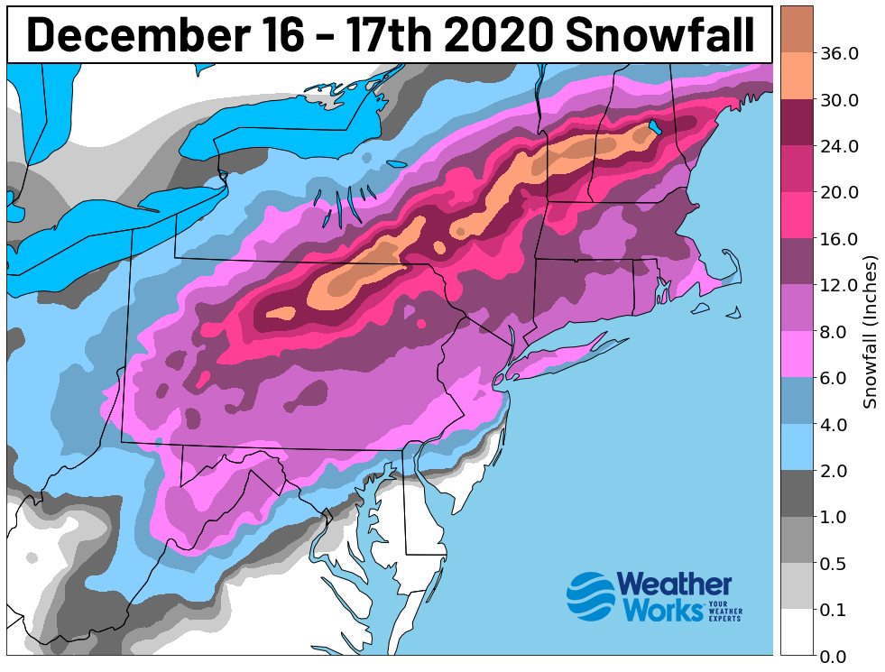
That was a huge snowstorm and the NYC area was clearly on the fringe.
-
On the HRRR, at 0z Sat (tomorrow), Orange County is at 2-4" while NYC metro is < 1". It's not the best angle of approach locally and there's still some concern there that the best banding could slide north and east into CT. On the plus side, the HRRR still manages respectable QPF locally and the low level convergence (inv trof) overnight Sat occasionally manifests as undermodeled localized banding.
-
Nice run from the 0z HRRR for NYC north and east. It even keeps light snow going into Saturday morning. Sleet mixes in briefly to the NY border. But... major snow to ALB, plowable to ORH, and accumulating to BOS is a bit of a red flag for us. The 700mb low is getting pretty far northeast before getting shunted south... For now we're all still very much in the game but still feeling nervous.
-
Playing catch-up with the afternoon's models and noticing that the 18z GFS is the best short range (24hr - 36hr) run for the ENTIRE NYC metro that we've seen in a while. An outcome like that would really spread the love. It's probably a bit optimistic, but still fun to see!
-
Probably gonna be some big parachute flakes as the sleet line approaches with flakes sticking together in the near freezing 700mb layer.. especially if winds aren't too strong.
-
It's cool to see solidly subfreezing temperatures in place for an event for a change. It looks downright cold in the lower Hudson valley tomorrow. It should transform the landscape no matter what wintry precip. falls.
-
The heaviest precipitation will probably fall after sunset... but it would be nice to get an hour or two of accumulating snow during daylight... we'll see.
-
In my experience, if the NAM shows sleet inside 48 hours, even if it's an outlier compared to other guidance, it absolutely can happen and often does. There is a good chance this run is north of the final outcome. But I really don't think the trend should be dismissed. The silver lining is a 2-5" snowstorm is possible for the metro even in the NAM scenario.
-
Warning snows to Saratoga springs with advisory snows to Lake George. That's rarely good for us. We don't blindly follow the NAM, but we shouldn't ignore a multi-guidance trend. Good thing is the NAM is still cold enough for frozen precipitation for many areas even if the focus of heavy precipitation is north and there's more sleet now. It also would end as snow showers.
-
The problem is all other guidance has been shifting north, focusing the snow northeast of the NY-NJ border. And we're squarely in the short range now. That makes it more difficult to dismiss.
-
No good on the 18z NAM. Not what we want to see at all.
-
Closer look it's actually virga. Snow looks to being in the afternoon on the model.
-
Snow breaks out late morning on the HRRR for northern areas. Interesting that this has evolved into a Friday daytime event as opposed to a Fri night - Sat morning event.
-
The pessimist in me says southwest of the NY-NJ border, this could turn into a quick (~2-4hrs) burst of steady snow followed by a period of light sleet and ending as flurries/snow showers.


