Bryan63
-
Posts
420 -
Joined
-
Last visited
Content Type
Profiles
Blogs
Forums
American Weather
Media Demo
Store
Gallery
Everything posted by Bryan63
-
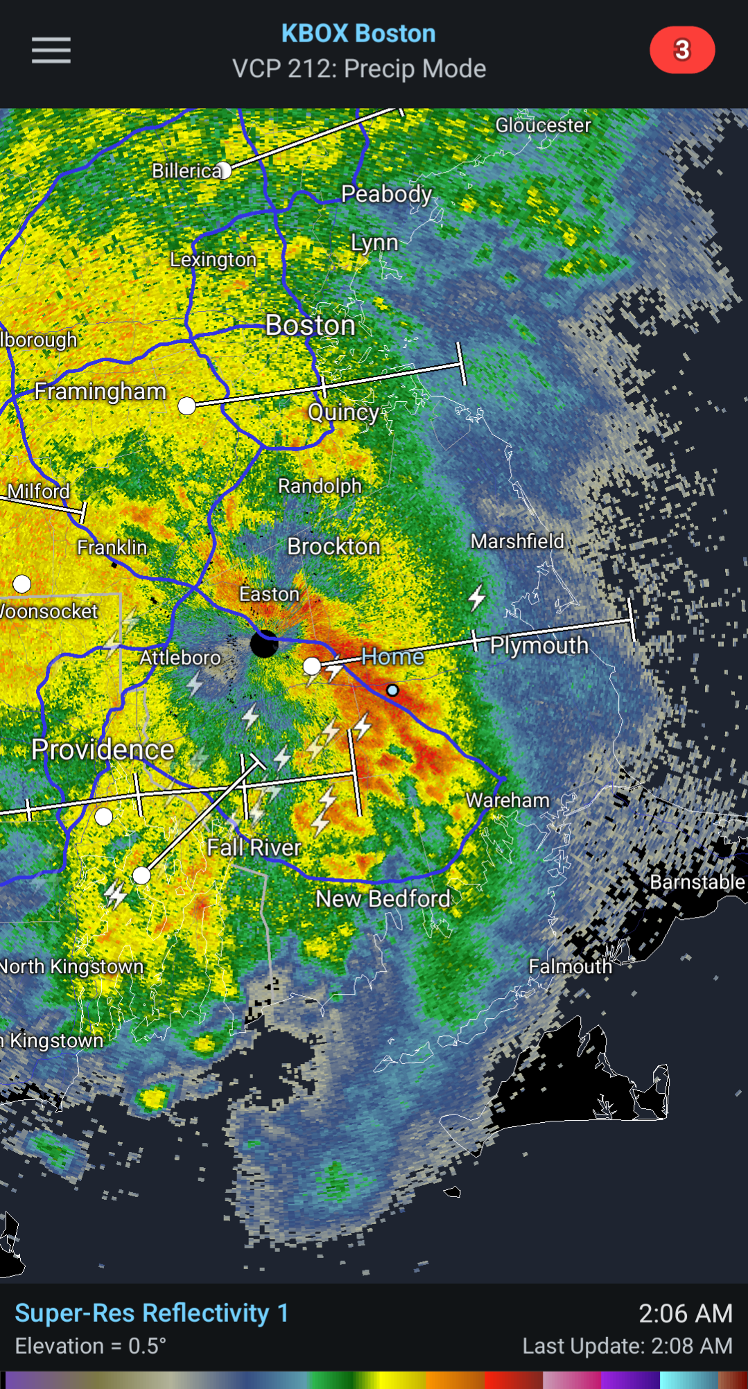
Heavy rains and lightning, like a late summer storm out there. Woke both my wife and I from a dead sleep. Surprised this isn't warned.
-
Man, the one thing I'm realizing with all this melting over the last few days is just how much clean up there's going to be this spring. Branches broken/bushes struggling from weight of snow, debris all over the yard.
-
With heating oil now up to $4.55/gallon through the company we use, as much as I love snow, I am very much ok if winter dies a quick sudden death.
-
"Don’t do it" 2026 Blizzard obs, updates and pictures.
Bryan63 replied to Ginx snewx's topic in New England
Middleboro schools officially closed for the rest of the week. -
Had a real estate agent in one of the local Facebook groups who has clients wanting to buy into the town, posted saying that this is a great time to move somewhere warm and if you're looking to sell to reach out. Thought it was clever marketing
-
Honestly not sure where we could put any more at this rate. I have 6 ft fence nearly gone in spots with drifting.
-
"Don’t do it" 2026 Blizzard obs, updates and pictures.
Bryan63 replied to Ginx snewx's topic in New England
Good morning from Middleboro where the snow seems even more impressive today with the sun out.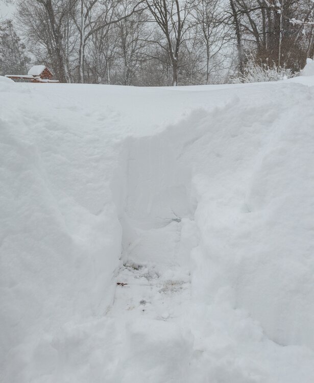
-
"Don’t do it" 2026 Blizzard obs, updates and pictures.
Bryan63 replied to Ginx snewx's topic in New England
What a wild day, finally got out back where we had about 6-8" left on the pack, snow is now up to nearly my chest and I am about 5"10. Neighbors have snow drifts over their first story windows. What a day to be a snow weenie. -
"Don’t do it" 2026 Blizzard obs, updates and pictures.
Bryan63 replied to Ginx snewx's topic in New England
Seems to finally be a hint of things starting to lighten up a but which I will gladly take, not sure there's room for much more at this point. -
"Don’t do it" 2026 Blizzard obs, updates and pictures.
Bryan63 replied to Ginx snewx's topic in New England
Just insane today, I have a snowdrift going up to and over my 6ft privacy fence. As soon as I clear part of the driveway it fills in. 85 yr old neighbor who's lived here his entire life said he's never seen anything like it. -
"Don’t do it" 2026 Blizzard obs, updates and pictures.
Bryan63 replied to Ginx snewx's topic in New England
Snow drifts are really starting to stack up now with the winds and drier snow. -
"Don’t do it" 2026 Blizzard obs, updates and pictures.
Bryan63 replied to Ginx snewx's topic in New England
What's the timing looking like for the wind? Every gust that comes through gives me more grey hairs. -
"Don’t do it" 2026 Blizzard obs, updates and pictures.
Bryan63 replied to Ginx snewx's topic in New England
Down the road in Middleboro, this has been an unreal stretch, just relentless. -
"Don’t do it" 2026 Blizzard obs, updates and pictures.
Bryan63 replied to Ginx snewx's topic in New England
Definitely can sense the snow is getting a little drier in the last hour or so. -
"Don’t do it" 2026 Blizzard obs, updates and pictures.
Bryan63 replied to Ginx snewx's topic in New England
Can only use so many metaphors, this is unreal. The band just refuses to move, relentless rates and wind. Kudos to Middleborough Gas & Electric, have done a great job investing into the infrastructure and so far it's showing. -
"Don’t do it" 2026 Blizzard obs, updates and pictures.
Bryan63 replied to Ginx snewx's topic in New England
Can't even measure with the wind, it is absolutely ripping. By time I finished first round of the driveway I already had 3-4" starting to pile up. This is a weenies dream -
"Don’t do it" 2026 Blizzard obs, updates and pictures.
Bryan63 replied to Ginx snewx's topic in New England
Dogs took one look outside and went back to bed. -
"Don’t do it" 2026 Blizzard obs, updates and pictures.
Bryan63 replied to Ginx snewx's topic in New England
Had planned to wake up and take first stab at the driveway but honestly not sure I feel comfortable doing so. -
"Don’t do it" 2026 Blizzard obs, updates and pictures.
Bryan63 replied to Ginx snewx's topic in New England
I can safely say that I've never seen anything like this before. -
"Don’t do it" 2026 Blizzard obs, updates and pictures.
Bryan63 replied to Ginx snewx's topic in New England
We are getting rocked!! Even between gusts it's difficult to make out much across the street. -
"Don’t do it" 2026 Blizzard obs, updates and pictures.
Bryan63 replied to Ginx snewx's topic in New England
Man these gusts are no joke, woke me up from a dead sleep. Can't see anything outside. -
"Don’t do it" 2026 Blizzard obs, updates and pictures.
Bryan63 replied to Ginx snewx's topic in New England
Winds picking up already, kids and wife are dropped off at mother in laws, beer is stocked, lets go! Reminds me of the '05 Blizzard my junior year, parents were in Florida and I was riding solo for that. -
Made the decision to send my wife and kids to mother in laws with a full house generator. Not feeling great about holding on to power here tomorrow with some aged trees on our street.
-
Thinking about sending the wife and kids my mother in laws house with a full house generator just to be safe. Not sure I want to be stuck in a power and heat less house with a 7 and 2 year old.
-
Yeah...this is going to be a good one down here! My son spent his first 5 years in NC and now is going to get 2 20"+ storms in one winter.