

ldub23
-
Posts
1,933 -
Joined
-
Last visited
Content Type
Profiles
Blogs
Forums
American Weather
Media Demo
Store
Gallery
Posts posted by ldub23
-
-
Happens every time here. The band goes west and stays together and the part that goes over me dries up.
-
Light snow in Newport News. Car topper.
-
 1
1
-
-
1 minute ago, Rhino16 said:
Why do heavier snow rates keep the air cold? Does cold air just get pulled down with the precipitation?
Did the rain take a huge punch to the snowpack? Monday’s interesting for down there, hoping for the best for you then.
To some extent heavy snow pulls down cold air but when the warm air aloft comes rates cant overcome it. We didnt have a snowpack. We got 2 inches but that was just about gone. Waiting for monday now.
-
Yall might get more than DC
-
Just now, eaglesin2011 said:
Has it turned over there?
Sadly, yes. Rain now. It started around 630 and lasted till 9am. The gfs stalls the low for awhile offshore mon/tues. Good chance we get more then.
-
About an inch in Newport News. Waiting for more mon night tues am
-
NP. Maybe it will be a season with 1996 like tracks.
-
Just so you know, however, that the analog system projects a very warm April and May, and a searing hot summer with multiple East Coast hurricane threats. So enjoy the chill and the chance for whote powder, because "Redux 2020 Hurricane Season" is high on the probability charts.Sleep well tonight.Prepared by Meteorologist LARRY COSGROVE on
Saturday, January 16, 2020 at 9:40 P.M. CT-
 1
1
-
-
Seems like the dry slot and warm nose always goes further north and west than expected. Alot of TWC reporters not in snow.
-
Snow droughts always end with a bang so DC looks to get 12-16
-
1
-
 1
1
-
 1
1
-
5
-
-
A few mangled wet flakes in newport news.
-
JB was going for a warm winter with below normal snow but then he got more bullish.
-
BWI: 23.3
DCA: 19.6
IAD:28.3
RIC: 14.8sby 16.0
-
This UKW is the strongest yet of this La Niña event due to a persistent series of strong EWBs that has been observed during the last few weeks. The arrival of this UKW to the east eq. Pacific should push ENSO solidly into moderate-strong La Niña territory through winter 2020-21. pic.twitter.com/1tVRZdk0DL
-- Tyler Stanfield (@TylerJStanfield) October 22, 2020-
1
-
-
On 9/28/2020 at 1:11 PM, the ghost of leroy said:
Yup. Just total trash.
Models are really cool now on anything of interest developing.
-
4
-
-
GFS now showing nothing. Looks like we have indeed ended the season very early. ACE per storm not at all impressive this season.
-
2
-
2
-
-
If that stays over water awhile it might develop.
-
Very ominous when the Euro and gfs agree
-
1
-
-
No US landfalls? I guess you arent counting the 18Z GFS with a major over the US virgin islands and a building positive NAO which means if that monster is still there in 8 days it aint OTS.

-
1
-
-
1 hour ago, Eskimo Joe said:
This season is such a low energy bust. There's not even been a decent fish storm with nice satellite presentation.
Just goes to show seasonal forecasting has a long way to go. I was reading the NHC disco on little paul and they mentioned how "Parched" the atmosphere is. everything is parched and sheared even though the east pac continues to cool. I still think sept20-oct 10 might offer something interesting but i also think oct 10 is about the end of the season.
-
4
-
-
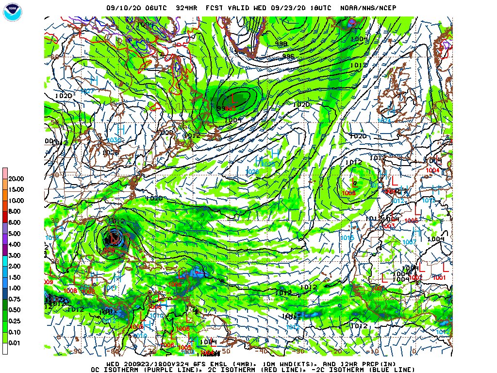
18Z continues the pattern of every other run being more active. The weak storm at 12z in the se carib is now a monster east of the virgin islands, and paulette which had dissipated at 12 z gets trapped north of bermuda.

Notice now paulas remains are nw of bermuda instead of ne and the set up for the ridge is for it to be stronger. the monster east of the virgins needs to be watched

-
1
-
-
2 minutes ago, CheeselandSkies said:
If it were El Nino the Pac would be going crazy...I've been counseling patience the last few weeks but even I have to start wondering now...where are the stadiums (apart from Laura's last few hours)?
Im just saying the atlantic west of 50 is classic el nino. Even rene looks dried up though maybe as it turns north it will get stronger.
-
1
-
-
With satellites and a generous naming group of forecasters 1926 might have had 35/20/12. Average of 20 ace per storm. 1893 as well. We are really insulting 2005 in a big way by making comparisons to this season.
-
1
-
-
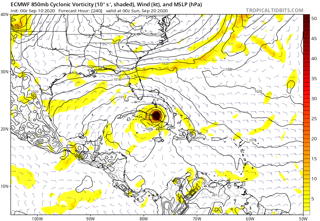
Euro and GFS this afternoon both coming back to the reality of 2020. Alot of weak sauce with conditions rather hostile. Might not get my major well east of bermuda if there is another one. Now they both give poor paulette a miserable sheared dry death and conditions look horrid west of 50 and rather marginal east of 50. West of 50 thats a picture you expect to see in the 1982 or 83 or 94 or 87, or 72 season. Classic el nino look. Poor Paulette is about to get the dry air/shear combo. It already has the dry prunish look. And given the predictions of Hyper-diaper Super-Duper conditions this season this isnt the picture i would expect to see on sept 08.

-
3
-

Richmond Metro/Hampton Roads Discussion
in Mid Atlantic
Posted
Radar showing a last band forming to my west. Since whatever snow falls will do so after dark maybe another car topper.