

ldub23
-
Posts
2,286 -
Joined
-
Last visited
Content Type
Profiles
Blogs
Forums
American Weather
Media Demo
Store
Gallery
Posts posted by ldub23
-
-
7 hours ago, GaWx said:
The 0Z slams SE FL with a cat 2 H early on 9/2 from the same E Atlantic wave:

As expected in a dead season it appears to have been dropped by the GFS and Euro due to the continued hideous conditions. Not a surprise. Euro has another low later but will be dropped within a day. GFS has some slop here and there but basically nothing. Dead City.
As far as the BOC, just whats expected in a dead season.
Nothing can get across the Sahara. Pukeworthy season. I cant remember a season where we didnt even have waves to track

*** Please tropical Gods dont mess up the 0/0/0 Aug with a BOC nothing.
-
56 minutes ago, WxWatcher007 said:
What is the GFS trying to do out in the MDR???
It brings back the cane it dropped. Almost a good enough pattern.

30 hours later it hasnt moved a whole lot and looks to get trapped under the high

-
Another 5 yard false start penalty or finally the real deal? Check the lower right.

Its put up or shut up time
-
 1
1
-
-
This was issued Aug 09 and its been dead since then. I have averaged out the numbers. 8.5 hurricanes, 4 majors, 138 ace for the remainder of the season. All i can say is if we get to these numbers it will be a wild ride indeed. Im doubtful, but read for yourselves.
https://www.cfact.org/2022/08/18/2022-hurricane-update/
"I think we will see a fast and furious period from mid and late August into early September, followed by a lull and then another active period. I don’t have any below normal risk impact areas, though there certainly will be when the season is looked at retrospectively."
Mid to late Aug is here and no canes, no majors.
-
1 hour ago, GaWx said:
The 12Z Euro is sticking with the idea that this lead AEW won't develop. So, the GFS suite continues to be largely on an island for that wave.
The 12Z Euro has no TC anywhere in the basin on its entire 10 day run.
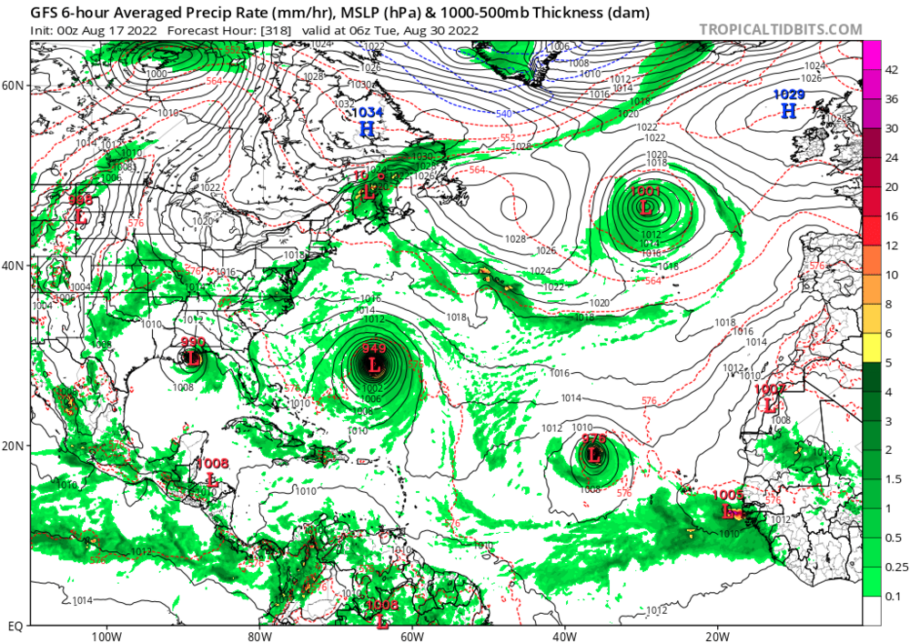
As i suspected it has no Atlantic super cane nor GOM super cane. It does have a ton of bone dry air everywhere with rather high pressures in the tropics. All i need to do is look at this picture to know the pattern shows zippo signs of change. We have a winter time storm hitting Maine, low pressure locked over the NW ATL, chaos in the west ATL(Trofs and shear) no clouds in the deep tropics, and oodles doodles of bone dry air. When this satellite map has a well formed cane west of 65 and south of 25 with a west component in its direction then wake me up. This is getting ridiculous. Unless or until the euro can confirm what the GFS is fantisizing about then its not happening.
The time for hints, signs, and model storms is over. All Clear on the Western Front.
Can someone please let me know where that damn hurricane season switch is? I will gladly turn it to the "ON" position. I would love to be wrong and have something to track other than the latest dry air surge or east coast trof.
WHERE'S THE BEEF??

Euro says we are getting close to a 0/0/0 Aug.
This tweet is from yesterday. Its clear now this wave will croak like 97L did.
-
 1
1
-
-
14 minutes ago, Normandy said:
See you in November iduB! The bell has been rung. GFS nails the Gulf Coast with the seasons first major.
We will see. The Atlantic super cane is a "ghost" of its former self at 12Z and if i remember correctly back in June the GFS insisted a major cane was going to hit the gulf coast. It didnt form, much less hit anything..
Mid day Euro will be out shortly. If it shows nothing at 240 then its doubtful anything of note will form.
-
4 hours ago, tiger_deF said:
0z GFS going nuts
Lets see what it looks like at 06Z. Just need the wheel to be a bit stronger.
-
 1
1
-
-
12Z the major hurricane turned into a 1010mb nothing. 2 other weak lows. For peak season this is rather pathetic. There is also a potent TUTT which is no doubt why the monster cane turned into a tame teletubby.

This is Sept 01 with absolutely nothing of note. At least at 06Z you could see the edge of the phantom cane in the lower right.

-
4
-
-
0Z not all that thrilling for phase 2 and season peak. Hints and signs though!!
-
3 hours ago, CheeselandSkies said:
How's that 0/0/0 August looking, @ldub23?
Several points. If they dont get close to land them im still right because the preseason forecasts had higher than normal chances for a season of note. If all we get is climo or less im right because this was supposed to be at least more active than normal if not hyperactive. And finally, 06Z GFS put the lid back on with tons of dry air and higher than normal pressures in the MDR. And, i dont give a rats rear end about some weak low that forms at 33N 54W and zippity doo-dahs NE. Here is the 06 GFS with the lid firmly back on.

Are a few storms going to form between now and Oct 01(the season will have an early end)? Sure, but i am quite confident the preseason forecasts are going to fall flat on their faces. With this pattern the waves will come off way too far north to even matter and any wave that manages to get into the Sahara has a doubtful future at best. We have one hell of a TUTT out there as well. Looking at that pattern any miracle storm that does form in the MDR is bebopping out to sea so its meaningless. Now, keeping alive the hopes for a 1 storm season of note we need to look at the high pressure over the Northeast. IF that can hold thru mid Sept then we need to hope something can get going in the far western basin under the ridge.
*******Im not being a jerk i simply can not reply to people here because i can only post 5 times a day. I can talk via PM.
-
1
-
-
Its been so dead in the tropics i figured i would post this. Its a quote for Larry Cosgroves great newsletter.
"And should we follow the pattern seen in the Southern Hemisphere, with more and frequent cold pool advances toward the Equator, and flip it to our side of the world, then an argument exists for a very active, and notably colder winter to the right of the Rocky Mountains to the East Coast.We still have time to look at pattern evolution. But if you are a fan of winter weather, you should be smiling right about now. I know I am!"I think we will see 150% of normal snow from RIC-BOS.-
1
-
-
We are in phase 2 at the peak of the season(aug/sept) and not a single cane is forecast by any model. This is why i think Sept will be below normal. Phase 2 will be gone by mid sept, if not sooner.
At least phase 2 is producing another cane in the east pac.

-
1
-
-
43 minutes ago, NorthHillsWx said:
That is purely a non-tropical nor easter. It has a front attached and a very chilly backside. That’s probably the worst sign for tropical activity at the moment possible. Restregthens the east coast trough and pulls in a fall-like airmass. Will be interesting to watch and probably new England’s best chance at much-needed rainfall but that is NOT tropical
I agree. The season ending winter pattern has arrived early. I am also surprised that once again we are in the super duper favorable phase 2. I must have missed how phase2=The Sahara. 100% dead MDR and even if that weak low forms off VA and is partly tropical its the exact thing you would expect to see in a dead season. Mid Nov and this would be a big early season Snowstorm for the NE. Another nail in the coffin of the 2022 Sahara caneless season. It looks like the phase 2 sahara version of the MJO will be gone by Sept 10. After that they may not have graphs that will be able to show the massive lack of moisture in the MDR.
CSU, if you are listening do an emergency update and forecast 4/1/0 for the rest of the season.
Lows have been regualrly forming in the massive offshore trof for sometime. We have one today, though not as strong as the low next week. The sad thing is for snow and cold lovers that eventually this wintertime pattern will reverse to a pattern that would be favorable for hurricanes but by that time all it would lead to is a mild winter.

-
3 hours ago, Ed, snow and hurricane fan said:
If I was post limited I would have saved this post. I see you, I know the season looks like it will not start before very end of August, and may not be superactive. GaWx or somebody posted about a third year Nina. Late start and over 100 ACE still possible, especially with Gulf and Caribbean in October.
Bummed, can't log in work Google account...
ETA- if I were a degreed meteorologist and had a social media following, I'd have done 10/20 mainly because of ensembles. I did post that, with a shortened Storm2K 'take this with a grain or 18 of salt' on Twitter just after 7. 10% lemon with an invest tag, that is rare...
The way this season is going 5 posts a day will be just fine, lol. As we can see here the reason the GFS contines to keep the Sahara bone dry is because of super duper high pressure in the tropics. Look at the last frame. INCREDIBLE. No wave will make it thru that. We will see just how much the gulf and carib can do with this pattern. I suspect not much. Also, move your eyes north from the tropics and notice there is no wheel. High pressure just keeps moving west to east and never locks in. That pattern is NOT conducive to late season activity. We are already getting cooler than normal air in the east now. I didnt think that would start till mid Sept. This is the early winter pattern i have been talking about.
I hope texas gets some beneficial rain and even without a weak low the rain is coming.
Here is the GFS forecast for TX rain

In summary this pattern will have to reverse or sept will be as dead as Aug. And if the pattern doesnt reverse i will have to disagree about Oct.
Addendum: Also notice the coast of Africa. Because of the super duper wooper high pressure the waves are squeezed way too far north so there may not even be any waves to worry about.
-
15 hours ago, Ed, snow and hurricane fan said:
Double secret probation home brew TD/TS alert is now in affect.
A quick td trying to develop in a year that was supposed to be hyperactive. *sighs*
-
22 minutes ago, GaWx said:
I was going to say not to mention the obvious that the last thing the sane amongst us who live not too far from the coast want to happen is a hurricane plowing in and likely causing at a minimum temporary major disruptions to our families' and friends' lives due to the huge inconvenience from having to evacuate (especially for disabled bedbound persons and their caregivers like in my situation..I don't even know how I'd be able to do it), alone, and of course the potential for long lasting power outages and worse yet, damage and even casualties for those who try to ride it out. So, ldub's version of "bad news" is the exact opposite for some of us coastal folks. I just feel it is pointless to repeatedly preach the obvious at a wx forum. But I'm human and will speak my mind on this at times. Your comment gave me a perfect time to do so. This is a reminder that hurricanes are huge life disruptors wherever they hit and are not just a game to see where they will go.
Regardless, when I post in the tropical threads, I try to do it in as objective a manner as possible. My goal is to be informative and accurate while not allowing anyone to tell what my desires actually are.
Now can you explain how wanting something translates into making it happen? And would you be nice enough to go into the winter threads and scold them for wanting weather that kills far more than hurricanes. Right now in the mid-Atlantic forum they are in panic and meltdown because the evidence seems to indicate a mild winter. Let them know they should be rejoicing and arent being nice wanting weather that kills. Oh, and please let storm chasers(who desperately want strong tornados and hurricanes to form though no doubt they can claim purity by using their thoughts to keep what they want from hitting populated areas) know your feelings about what they desire. If someone, anyone, can show how I, snow and cold lovers, storm chasers, and others can control the weather with our thoughts please do so. No one who posts on this forum came here to post because they like warm sunny 72 degrees days year round. And one last thing. No doubt we will get someone saying, yea i want to watch cat 5 hurricanes but i want them to stay out to sea. Its awesome you can control them that way. I sure cant.
*I dont want to sound harsh. I am quite certain you mean well and want the best for everyone.
-
 1
1
-
-
1 hour ago, Normandy said:
Eating my popcorn watching this unfold. Idub looking strong today!
When JB threw in the towel earlier this morning i knew things were looking OK. There will still be a few storms, i think anyway. As i said earlier a nothing can spin up just off the African coast. IF,and i do mean IF, a wheel forms and locks in then its possible to get something in the bahamas or NE GOM.
Something else i noticed. For quite some time Dr Knabb has been saying the favorable conditions were going to leave the EAST PAC and move over the Atlantic. He wasnt using climo. It was going to happen. Then 3 days ago he started to talk about how CLIMO said the atlantic would get more active. We can still have a 1 storm season where 1 storm manages to make it thru.
-
Sad that in the middle of what supposed to be a very active season we get to read about dust in FLA.
JB is starting to go wobbly. Says we "should" see activity pick up but for the first time this season brings up a model saying nothing will happen. JB is beginning the process of backtracking. 0/0/0 Aug? Followed by a 0/0/0 Sept??. All JB is doing now is reciting climo. Its AUG 11. Things damn well better pick up.
Oh, if this is phase 2 in the Atlantic what does an unfavorable phase look like?
Oh, again what does an unfavorable phase of the MJO look like? If we are in phase 2 now maybe we need phase 17.38
Does phase 2 look like this? I am so rooting for a 0/0/0 Aug.

Oh, and look at the African coast. Waves will come off too far north to matter anyway.
My guess is the only place we MAY see development in the Sahara is just off the African coast. If a strong wave can time its splash down into the atlantic with a brief pocket of moisture it might spin up into a weak nothing before it bebops north or croaks of thirst.
-
30 minutes ago, Ed, snow and hurricane fan said:
It might actually rain at my house in Houston after 2+months of 2011 heat/drought. I'm back to work, can't look at every model, but haven't seen any model support. But front in the Gulf and light shear. Probably not the last August front, which bring only a DP drop and no cool air/high winds to rob OHC

Glad you are getting rain and cooler temps. Im starting to wonder if Aug is 1/0/0 or even 0/0/0 could Sept be even deader? Could Sept be -1/-1/-1?. New CFS just in and it makes the Sahara look like a tropical paradise compared to the dried up prune ATL. CSU needs to do an emergency update to 4/1/0 for the rest of the season. October to the rescue!! I have been reading where the experts are saying the super duper favorable conditions were going to vamoose in sept. Maybe the ATL will just dry up and we can walk to Africa.

To be fair here is what Klotzbach just said. The Atlantic cant do what he is implying if the CFS is right. I hope and pray Phil is right but im doubtful. Warm SST's are great but they cant overcome what the CFS is showing.
Ill go with the 2009 52.6 ace.
-
1
-
-
1 hour ago, Seminole said:
I think it is safe to agree that peak SAL is not going to happen until Mid August or even later given current conditions. Any TC formation would likely be in the GOM or Western Caribbean in the near term.
GFS says 0/0/0 is very possible except for 1 weak nothing in the middle of nowhwere. I guess the GOOD news is that would be another name. The bad news? It appears to get stuck in the central atlantic. That means killing the already anemic wave train and flooding the Atlantic with massive dry air. Oh, the east pac el nino cane fest just keeps on going. Normally the reason the east pac slows down in a typical season is a wave will finally develop in the tropical atlantic which in turn ends the wave train entering the east pac. Absolutely no sign of that on the 12Z. I seriously doubt that 1972, 73, 74, 82, 83, 97 looked as barren as this.
2 more East Pac canes lined up and ready to rumble with more on the way in an impressive East Pac El Nino.

Yes, those years were barren and this season mimics them. 2 more points.
A- The experts are now already telling us when the super favorable conditions will leave the Atlantic before they even begin(maybe they have begun and this is the best they can do). Thats not a good sign for even a normal season.
B-This nowhere man weakie comes from 97L. What does that tell us? In dead seasons storms have to escape the tropics to develop.
What the hell, 1 more fun idea
C-Maybe with the wheel to help, 97L will get trapped and do a Ginger and come all the way back to the US coast and listen to what JB says about how this amazing Super Season will feature in close rapid feedback development and turn into a cat 4 just before hitting Cape Lookout. Yea, thats the ticket!! 100% chance of that happening.
D-Can we all chip in and pay for California water dumping Planes to load up with water and dump them in the bone dry Atlantic?
-
1 hour ago, WxWatcher007 said:
Basin still sucks right now.
Looks like the wheel is going to be wasted. At least it will be cooler here. Give JB credit for the wheel but will it only last a week? I hope it lasts for 3 months like the Trof did. 0/0/0 still on the table for August. Something weak might pop up but zip for August would be pretty cool.
http://moe.met.fsu.edu/tcgengifs/ecmwf-oper/2022081000/slp8.png
-
1
-
-
1 hour ago, etudiant said:
Same here, although in fairness I found the discussions much more worthwhile than the specific forecasts.
If they offered a discounted 'discussions only' rate, I'd be tempted to resubscribe.
That said, I've nothing but respect for JB, he called Sandy correctly in the face of much disparagement. I know forecasts are really hard, we can't even get the five day call reasonably correct, so I admire anyone who sometimes is blessed with understanding.
Well said. JB is the role model for many.
-
97L bites the dust. Ive issued a Slow and Tame warning. There are some changes in the pattern. Texas will get wetter, the east is cooling and the wheel might be coming. Maybe by sept 10 the tropics will be active.
-
4 hours ago, SnoSki14 said:
This is actually not good because it'll favor development close to home whereas most central & eastern Atlantic storms would recurve.
The wheel seems to be there but there is nothing that can take advantage of it. 97L just has no chance and while 18Z had a hurricane cruising west after 97, 0Z is much weaker and north. East pac continues to roar on with cane after cane. Im sure by sept 05 conditions will improve.


2022 Atlantic Hurricane season
in Tropical Headquarters
Posted
Mocking me hasnt worked out that well so far this season, lol. Now you have cursed the next wave as well. I have doubts it will amount to anything. Greg Postel was talking about it and then ended with saying there is no guarantee conditions will be any more favorable in a week than they are now. Its possible it could be a nothing storm that croaks soon after developing.
WHERE'S THE BEEF?