

ldub23
-
Posts
2,284 -
Joined
-
Last visited
Content Type
Profiles
Blogs
Forums
American Weather
Media Demo
Store
Gallery
Posts posted by ldub23
-
-
2 hours ago, Cary_Snow95 said:
As expected GFS is trending towards other guidance with a weaker system
Nothingburger in a sea of dry air with the locked and loaded central atlantic low making this 1983. If this is the best this crummy clump of clouds can do i dont count this as the beginning of the season. Nothing behind the wave either due to the central atlantic low. Amazing that i wanted a pattern change and got one, and it was even worse than before, lol. This is the peak of the season? Nothing?
Oh, and this is for the ghouls who pray for snow and cold in the winter.
- Each year in the United States, about 1,330 people die of cold exposure, essentially freezing to death. You may picture outdoor adventurers dying of hypothermia on snowy mountaintops. While rates are higher in rural areas, many cold-related deaths and illnesses occur in cities too.
www.publichealthpost.org/research/counting-cold-related-deaths-new-york-city/The Dangers of Cold Weather - Public Health Post
For some reason this picture wont display but if you click on it the ATL is as dead as a rusty doorknob. BUT!!! IS THAT A WHEEL IM SEEING?
http://moe.met.fsu.edu/cgi-bin/ecmwf-opertc2.cgi?time=2022080812&field=Sea+Level+Pressure&hour=192hr
-
 3
3
-
11 hours ago, cptcatz said:
Why are any of us on this website if we don't enjoy watching the extremes of weather? The way I see it, it makes no difference what you root for since it has zero impact on what will happen.
Well said, and tornado chasers beg and pray for F5's to get videos to sell. Winter weather kills more than hurricanes. Sunny weather kills people.. Now here is the perfect pattern and the GFS has a cat 2 almost on top of me. But, somehow it doesnt get turned by the low at 240 hours and the GFS has been showing canes here and there for several weeks. At 0Z it had a storm hitting the GOM thata gone at 06Z.

-
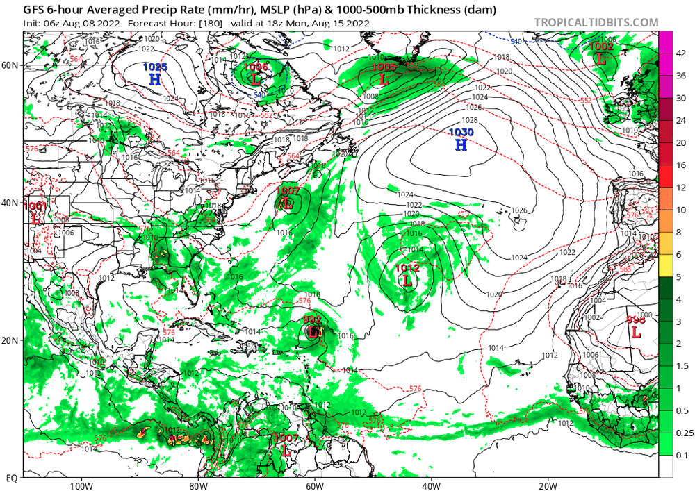
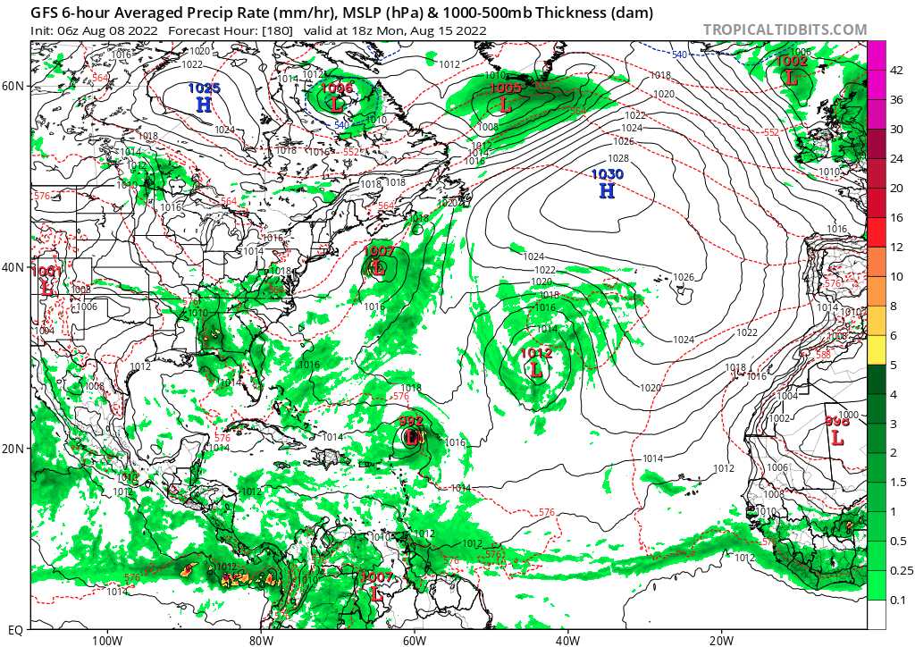
Meanwhile, this latest super wave has trended weaker and weaker on all models. At the very best its a short lived nothing. This wasnt advertised as a season without MDR canes. As far as that group of showers off the se coast if this were just a normal season it might have a chance to sit there and develop. It isnt a normal season, its a dead season with a huge west ATL trof. That means nothing will be able to be trapped off the se coast and develop. For that to happen you need a locked in High over the NW ATL. With a trof all you can possibly get is a very weak strung out low ripping NE with no chance to be anything more than a weak depression that CANT threaten the US. Here is a perfect example of what this hideous pattern can produce.

What do we see? The never ending trof off the coast is what we see with another trof ripping east to reinforce it. On the offshore trof we have 2 very weak lows trying to form, but thats all they can ever be because there is no blocking high to keep them in place to develop. They just get stretched out NE and will never amount to anything. And once once once once again the whole pattern, no moisture in the MDR, mega west atl trof, all models agreeing there will be no MDR season, and the latest ballyhooed wave never amounting to anything makes the CFS quite believable. I will leave you all on a positive note however. See that one blue line in the upper right corner? Thats winter baby!! That will eventually put an early end to this miserable bust of a season.
*It would certainly be nice if some of the pro mets on here can explain how the season is still going to be active.
And here is the map 24 hours later.

We see the same 2 areas that were trying to develop. They CANT and WONT because yet again we have a monster trof blasting off the east coast. Even in the totally dead season of 1986 we had hurricane Charley form off NC and hit as a cat1 in NC and SE VA because it had time to organize.
I have alot of respect for Larry Cosgrove. He has been the only met who early on recognized the reality of the season.
https://groups.google.com/g/weatheramerica/c/gT3GLZPcgow
"The major islands, Caribbean Sea nations, and the Eastern Seaboard all have prominent windows for a named storm or hurricane strike in a window between August 23 and October 15. But I will repeat that the number of storms will likely be reduced from the two years past, since the Maximum Development Region convection will be reduced, and chances for a Gulf Coast impact are crushed because the heat ridge complex will either be over Texas or the "Four Corners". Steering and subsidence can greatly reduce your chances at seeing a prominent tropical cyclone. Despite whatever you read on an internet weather forum or because waters near your community are incredibly warm."
I hope he is right about the eastern seaboard though that wont happen unless or until a locked in ridge replaces the trof. He is certainly right about a Gulf coast impact being highly unlikely.
Finally its LC vs JB
-
I found this on another site. The CFS says everyone yelling about the favorable condidtions coming are nuts. It has 1 weak nothing between aug 20-sept 26.
0/0/0 Sept possible?
Pretty amazing really. A few days after CSU says 18/8/4. NOAA about the same, and JB issues a fast and furious watch and just this morning implies hyperactive is coming the CFS takes a dump on them saying 1 nothing between Aug20 and Sept 26
-
1
-
-
Euro a bit less enthusiastic on the wave. However JB says it "MAY" get hyperactive
"In close" will be hard to get unless the mega trof is replaced with the Wheel.
Meanwhile the East Pac is hyperactive with 3 lined up and more on the way. For a hyperactive atl that will also have to change.
WOW!!!!!!!!!! GFS showing the first wintertime low ripping across the eastern US. Earlier than even i thought

Meanwhile, even though the "experts" insist the tropics are primed to come alive the Euro is pathetic thru Aug22. Lets face it, anyone now saying the tropics are going to come alive are just repeating climo, nothing more. They sure as hell better come alive if there is going to be a season.

Finally at hour 384 we have 1 trof protective trof off the coast while yet another one is slamming east to replace it. 54 this aint. The whole US coast is snug as a bug in a rug with this pattern.
-
4 hours ago, Cary_Snow95 said:
Wave breaking continues to wreak havoc on the MDR. Mid Latitude dry air is being consistently driven into the MDR. Latest Euro further strengthens the sub tropical low sending a surge of dry air south
Atlantic ridge totally gone. Just when the experts are all in unison on the favorable conditions arriving we get stuck with a massive central atlantic low and no ridging. What a piece of crap dead season. Have the "experts been more wrong?
DT-"August will be sideways" NOPE
JB-Fast and furious watch-NOPE
Another 1954-NOPE
The Wheel-NOPE
CSU-18/8/4 Still way too high
At least winter time conditions will arrive early putting an end to the Non-season.
Next up: The super duper awesome fantastic favorable condidtions will arrive by Sept 15. Without ridging it doesnt matter how many canes form. Its all zippity doo dah bebop east of Bermuda.
And while the Atlantic ridge said "So long, Suckers" the overall pattern remains. Mega west ATL trof. This is why im confident of a very early ending season.

-
The good news and the bad news.

The good news is both the GFS and Euro develop a very weak low that might be a short lived TD/TS. But then they run into very unfavorable conditions in the west atl and poof. This overall pattern remains horrific for anything worth following. Gigantic low in the central ATL plunging more dry air into the tropics. Mega trof remains entrenched along and off the east coast. Nothing fast and furious about this pattern. If that low locks in then there is no hurricane season. Looks like the MJO and the moisture is still locked and loaded in the east pac. Not sure i have seen a worse looking map in mid AUG for tropical development. For whats its worth that super central atlantic low should cause additional warming in the tropical sst's.
-
Did someone say the super duper awesome fantastic conditions were coming? East Pac says this is a super el nino.
This is horrific for MDR development. A cat 5 cut off low wandering around the middle of the Atlantic. Tropics killer

TICK, TICK, TICK. CSU should have went 6/3/1 for the rest of the season and we might not make that with a very real probability The Fast and Furious watch will be cancelled, no wheel, no euro super ridge, and the east pac popping canes like bees to honey.
-
 1
1
-
6
-
-
CSU and Noaa are nice but the JB-o-meter has just issued a "Fast and Furious watch" I hope any of these 3 are right. 12Z GFS says not so fast. I think CSU is flailing just a bit. All of a sudden a cool subtropics is bad? Ive read the super warm subtropics of years past were bad for the MDR. Storms best start forming pretty fast to get to 15 more.
-
16 minutes ago, olafminesaw said:
Meanwhile, the 6z GFS had 4 hurricanes develop in the EPAC over the next 10 days
Thats no way to run a LA NINA, LOL
-
3 minutes ago, Great Snow 1717 said:
"Thou shall not bullshit the masses" ????
Euro is pathetic for the time period of 04-19 Aug. Dr Knabb keeps saying the MJO is stuck over the east pac and all he can do is say it has to move over the atlantic eventually. Why? Maybe it will just skip over the atlantic.

-
15 hours ago, cptcatz said:
Euro ensembles are picking up on it:
GFS/CMC/Euro are all starting to pick up on the MDR wave as well. Could be tracking two systems next week. So much for your 0-0-0 August prediction.
18Z GFS appears less enthusiastic
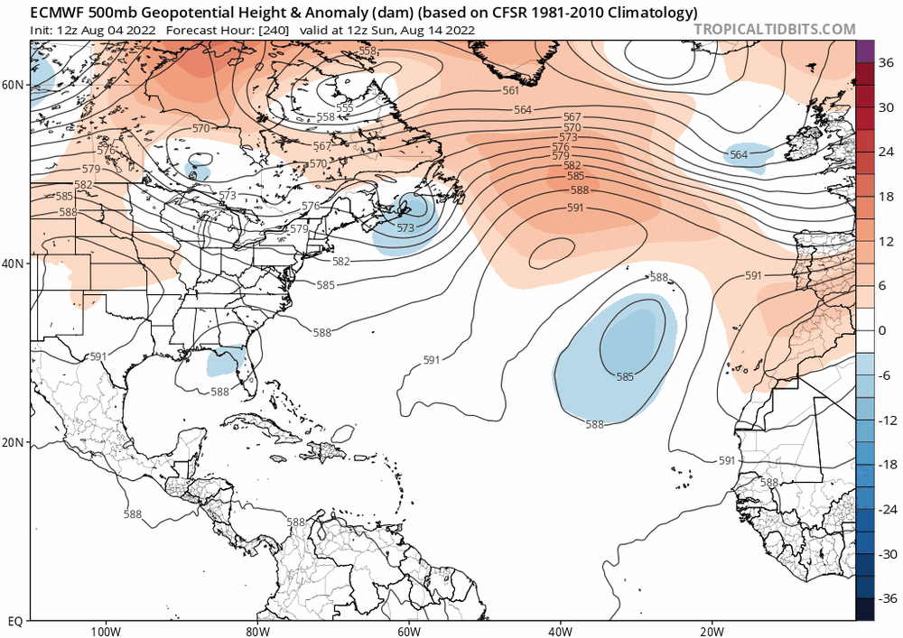
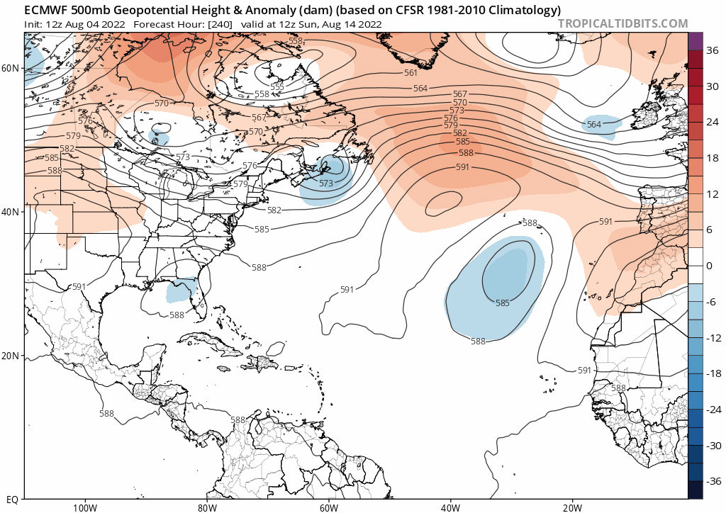
Euro even less enthusiastic. Mega super duper low over the northeast and as can be seen here that causes higher than normal pressure over the Sahara. Times up for hints and signs. WHERE'S THE BEEF!
http://moe.met.fsu.edu/tcgengifs/ecmwf-oper/2022080400/slp8.png
The JB-o-meter is stuck on Bible verses this AM. No mention of the Atlantic Sahara.
-
1
-
-
1 hour ago, Great Snow 1717 said:
Eh not happening. As usual he points out only one area that supports his narrative.
This is 1954 like if it happens. JB-o-meter hasnt mentioned it yet and will need to see it on the Euro as well.

-
JB brings up 1954. I would take that in a heartbeat right now.
-
1 hour ago, Normandy said:
@ ldub23
Can we make a deal? If the season ends above average can you never post in this topic again? I like your enthusiasm but I think we need some stakes on this take.
Only if the deal is that everyone who is wrong on anything can never post in the forum they were wrong in. Plus of course there are degrees of "wrong". What if the season ends up 14/7/3? Should everyone who forecasted higher than that vamoose? Also, there is a reason i post this map so often. Its because unless a hurricane can get in this picture i dont consider it "of note". You might say but a cat 4 just ran right over PR before turning out to sea east of Bermuda. In winter no east coast winter snow lover cares if a blizzard blasts Butte Montana or if the CA Sierra gets 200% of normal snow dec-feb while dc has 3.5 inches. If that happened the moaning and groaning in the Mid-Atlantic forum would be monumental and no matter if CA had 400% of normal snow while DC had 3.5 inches it would be considered a total non-winter.

1985 was 11/7/3 i think but it is one of my benchmark seasons. It was a hyperactive season for a reason. Something is wrong this season. Supposedly we are in a la nina and SST's are just fine yet it just cant get going. I personally consider the season at 1/0/0 so far as A and C should not have been named, but thats just me. Notice the dark red over the waters off se canada and the Northeast? Thats supposed to cause a blocking high. So far nothing.

-

This is from DT's public facebook page. 2 things to take note of. No mention of the tropics or a sideways august. Also look at week 3. Mean trough remains across New England. This pattern has persisted the entire summer. We will never have a Newfoundland wheel or Euro super ridge with the mean trof over New England. I know people are talking about hints and signs. I listened to Suddath talk about how the warm temps in the NW ATL means a ridge will be there. It sure wont be there in 3 weeks. Some storms will form but unless the pattern changes its a non season.
-
The JB-o-meter just went off.
12Z GFS says, yea the pattern is still horrid. Totally barren in the Sahara, hyperactive in east pac.

No wheel, no euro super ridge, no moisture. Aug starts as July ended.

Would everyone take 5/2/1 for the rest of the season and be happy?
-
2
-
-
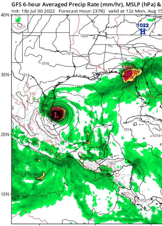
Im surprised this has gone unmentioned. Its a repeat of 2 days ago but with a cat1 cane hitting texas instead of a cat 4. How it develops is a bit suspicious. Since its starts in 9 days we can see if the euro shows anything today

The pattern shown on the euro at 240 with a front up and down the east coast and huge low pressure over the northeast makes me think this likely isnt going to happen. Maybe it will change today.

-
2
-
-
1 hour ago, GaWx said:
I wouldn't at all consider 1972 since it was a strong El Niño.
But this season is acting like an el nino. In fact, we cant even get a cloud to make it across the Atlantic.
This picture pretty much sums things up. There is no wheel, there is no euro super ridge, there is no moisture in the Sahara tropics, and waves are developing regularly in the east pac even though they are anemic dried up nothings until they get there. Right now there is yet ANOTHER low blasting off the mid-atlantic coast. This is why i am super uber confident of an early ending season. While its possible a switch will flip and the Wheel will appear i think its more likely as sept 15 nears the trofs will simply be stronger and more potent.

My 5 post limit means i need to reply here. I also dont think it remain this quiet. 8/4/2 for the rest of the season but i might bust too high.
East Pac says this is el nino baby!!!

-
"This is consistent with -ENSO climo, so it wouldn't be a surprise that things begin to change as we get closer to the peak.
Things are rough according to an EPS mean at the start of August, but as we get closer to the peak, the signal is for a less hostile basin."
You would hope they are going to change because they cant get any worse. Its very basic. There is a massive east coast trof displacing high pressure too far south turning the Atlantic into more of the sahara than the sahara is. Until that changes i agree we can ignore 2013, but look carefully at 1983, 1972.
And lets take out November because that can be dead even in active seasons. What is the longest time between invests? Should we have a contest on when the next invest will be designated?
-
11 hours ago, cptcatz said:
Here we go! Major into Mexico and another little something into Florida...
0Z was a bit less active. East pac still cranking plus the JB-o-meter didnt go off.
In a dead season like 2022 this is much more likely. A weak storm forming from a mid-latitude trof. With the east pac in overdrive we have el nino shear in the west carib and gom so until the east pac acts like a la nina a 938mb cane isnt likely in the GOM

This map also shows the overall pattern hasnt changed one iota. No wheel, no euro super ridge just a continuation of the mega east coast trof with dry air flooding the tropics.
-
5 hours ago, NorthHillsWx said:
It’s truly tough to envision the Atlantic as a whole being drier than it is this morning.
Like i was saying, the real Sahara has more moisture. Could CSU go 0/0/0 for the rest of the "season"? Obviously something will develop, most likely a nothing in the far east ATL that quickly either croaks of thirst or bebops north. Time to start thinking about 1983. There wont be an Alicia though, but maybe a weak storm will form in the western GOM. In a season that was as weak as the 2022 season look to the extreme east or west for something to form.
Hard to imagine the real Sahara having less of a probablity of a depression to form. We need a contest, "Will there be an invest in Aug"?
+

-
16 hours ago, cptcatz said:
What would (or did) ldub say at this point during the 1999 season?
I was most likely saying thank god Clinton is almost gone. As far as the season itself i seem to remember i was a bit optimistic. I cant remember the overall pattern that season but i know right now and at least thru aug 14 the Atlantic Sahara and the real Sahara will be equally dry. Here is a satellite animation of 1999 and it sure appears there was much more moisture in the tropics.
*Floyd flooded my house and car
Here is the Atlantic Sahara today. It may well be drier than the real sahara.

-
 1
1
-
2
-
-
Good article in SAL. Personally i think this season was dead due to the High being displaced too far south. Euro pretty dead thru Aug. Shows some activity in Sept but that might just be the model thinking something should be happening. 8/3/1 CSU on aug 04.
https://michaelrlowry.substack.com/p/blame-it-on-the-dust?utm_source=email

2022 Atlantic Hurricane season
in Tropical Headquarters
Posted
Im cancelling the Fast and Furious watch and replacing it with a Dry as a bone warning. I feel sorry for the poor waves in Africa. Before they head off the coast into the Sahara i hope they have their wills up to date. At least i can see signs of the wheel showing up. East pac has 3 areas of interest and 1 hurricane while the ATL has this.