

LibertyBell
-
Posts
40,111 -
Joined
Content Type
Profiles
Blogs
Forums
American Weather
Media Demo
Store
Gallery
Posts posted by LibertyBell
-
-
1 hour ago, bluewave said:
The June heat this year was very unusual on several fronts. The all-time heat records in the West occurred in June instead of July. All-time heat records are usually set in July. The Newark 103° at the end of June and 597 dm ridge were also early. So we’ll have to see if this means a rare June highest temperature. The active convection pattern coming up also feels like what we see sometimes in August after late July hottest temperatures of the summer.
When was the last time we had our hottest weather in June? 1994? I know in 1996 it was in May and in 1976 it was in April lol.
Weird the disparity in 1994 between NYC and PHL, in PHL the heat continued for the entire summer, but it didn't in NYC? In PHL 1994 was basically a repeat of 1993 wasn't it? Amazing combo of summers- 1991, 1993, 1994, and 1995, with 1992 the glaring exception rainy and cold summer! Not even cool, actually COLD!
By the way on this date in July 1999 we began our two day streak of 101 degrees, I loved that month, ended up with 20 90 degree days and our hottest month on record (beating July 1955) until July 2010 knocked it off. I love those 11 year summers!
-
 1
1
-
-
4 hours ago, Hoosier said:
We talk about the corn every so often in the Lakes/OV sub. Where the impact of that really shows up is in the frequency of high end max temps... say 100+. It has become increasingly difficult to get those temps.
If there is one area of the country where the all-time highest state temperatures are probably going to be fairly safe for a while, it would be the Midwest. Most of those all-time state records were set in the 1930s. There were some isolated areas of the Ohio Valley that flirted with 110 degrees in the drought summer of 2012, but it took the worst drought since the Dust Bowl in those areas to do it and those readings are still generally several degrees short of the all-time state records.
I wonder how much that big derecho took down? I heard damage was in the billions. Also, I read that many farmers are going out of business because of more frequent flooding and 3"+ rainfall events, so the corn business out there may be on the clock.....
I dont think thats sustainable farming anyway, monocultural farming is bad for the soil.
-
On 7/4/2021 at 9:23 AM, bluewave said:
Recent studies have identified +2 C of global warming as a critical threshold for the Arctic and Antarctic.
https://www.nature.com/articles/s41558-018-0127-8?WT.feed_name=subjects_climate-and-earth-system-modelling
Arctic sea ice has declined rapidly with increasing global temperatures. However, it is largely unknown how Arctic summer sea-ice impacts would vary under the 1.5 °C Paris target compared to scenarios with greater warming. Using the Community Earth System Model, I show that constraining warming to 1.5 °C rather than 2.0 °C reduces the probability of any summer ice-free conditions by 2100 from 100% to 30%. It also reduces the late-century probability of an ice cover below the 2012 record minimum from 98% to 55%. For warming above 2 °C, frequent ice-free conditions can be expected, potentially for several months per year. Although sea-ice loss is generally reversible for decreasing temperatures, sea ice will only recover to current conditions if atmospheric CO2 is reduced below present-day concentrations. Due to model biases, these results provide a lower bound on summer sea-ice impacts, but clearly demonstrate the benefits of constraining warming to 1.5 °C.The new study shows that if emissions continue at their current pace, by about 2060 the Antarctic ice sheet will have crossed a critical threshold and committed the world to sea level rise that is not reversible on human timescales. Pulling carbon dioxide out of the air at that point won’t stop the ice loss, it shows, and by 2100, sea level could be rising more than 10 times faster than today.
The tipping point
Antarctica has several protective ice shelves that fan out into the ocean ahead of the continent’s constantly flowing glaciers, slowing the land-based glaciers’ flow to the sea. But those shelves can thin and break up as warmer water moves in under them.
As ice shelves break up, that can expose towering ice cliffs that may not be able to stand on their own.
There are two potential instabilities at this point. Parts of the Antarctic ice sheet are grounded below sea level on bedrock that slopes inward toward the center of the continent, so warming ocean water can eat around their lower edges, destabilizing them and causing them to retreat downslope rapidly. Above the water, surface melting and rain can open fractures in the ice.
When the ice cliffs get too tall to support themselves, they can collapse catastrophically, accelerating the rate of ice flow to the ocean.
The study used computer modeling based on the physics of ice sheets and found that above 2 C (3.6 F) of warming, Antarctica will see a sharp jump in ice loss, triggered by the rapid loss of ice through the massive Thwaites Glacier. This glacier drains an area the size of Florida or Britain and is the focus of intense study by U.S. and U.K. scientists.
To put this in context, the planet is on track to exceed 2 C warming under countries’ current policies.
Other projections don’t account for ice cliff instability and generally arrive at lower estimates for the rate of sea level rise. While much of the press coverage that followed the new paper’s release focused on differences between these two approaches, both reach the same fundamental conclusions: The magnitude of sea level rise can be drastically reduced by meeting the Paris Agreement targets, and physical instabilities in the Antarctic ice sheet can lead to rapid acceleration in sea level rise.
The disaster doesn’t stop in 2100
The new study, led by Robert DeConto, David Pollard and Richard Alley, is one of the few that looks beyond this century. One of us is a co-author.
It shows that if today’s high emissions continued unabated through 2100, sea level rise would explode, exceeding 2.3 inches (6 cm) per year by 2150. By 2300, sea level would be 10 times higher than it is expected to be if countries meet the Paris Agreement goals. A warmer and softer ice sheet and a warming ocean holding its heat for centuries all prevent refreezing of Antarctica’s protective ice shelves, leading to a very different world.
So 2060 is D Day for the planet to free itself from the plague virus that is humanity eh?
Question....so it turns out that curbing emissions wont stop this existential threat from becoming reality by the time we reach the +2 C tipping point?
-
On 7/4/2021 at 1:06 PM, MJO812 said:
Joey Chestnut just ate 76 hotdogs in 10 minutes
New record for him
Wow
He had one for every game the Mets will win this year lol
-
 1
1
-
-
On 7/4/2021 at 1:26 PM, Will - Rutgers said:
every day we stray further from god
havent had that processed crap in years and never will again.
I think the AHA and ACS warns us to limit it to less than 10% of total consumption, Joey must be eating it at about 110% lol
-
51 minutes ago, bluewave said:
The latest EPS weeklies have an active storm track the next few weeks. So it’s possible that the 103°at Newark last week won’t get surpassed for a while. Sometimes it can be tough to rival a heatwave once a pattern becomes wetter.
July 5-12

July 12-19

Thats what I wanted to ask you Chris, do you think the 102-103 there Jun 29-30 was the peak hit of the summer? Since it happened at the tail end of June, it was basically July weather starting a day or two early. Or do you think we have prospects of beating that kind of heat later in the month (say around July 20th or later?) Speaking specifically for JFK and coastal areas.
-
7 hours ago, SACRUS said:
After a fabulous fourth its a trip back into the frying pan after today. Today a splendid summery day sunshine (outside some high smoke) and highs in the mid and upper 80s. Frying pan Tue and Wed as piece of the western heat spills east over the area. 850 temps >18c - 21C. Depending on smoke from the fires, as others have been discussin LGA and EWR and other spots could see the century mark Tue (7/6) - Wed (7/7). Cue Sonny and Cher the Heat goes on.
Watching the tropics and exact track of Elsi, some storms enhanced Thu and Fri (7/9). Otherwise very humid.
Season of the Western Atlantic Ridge comes back in the 7/10 and beyond 595 DM forecast along the coast by next Monday (7/12).
Overall warm to hot, with routine storms (Florida - style) pattern marches on.
that 595 DM pattern equates to what kind of temps along the coast Tony.....mid 90s?
-
20 hours ago, donsutherland1 said:
61 in Central Park.
I heard JFK set a new record low this morning (I mean yesterday morning now lol) at 59!
Is a low of 59 or lower rare there in July too?
-
14 hours ago, uncle W said:
on the flip side of extremes July 1917 had two days in a row like yesterday was on the 9-10th...the month ended with a 100 degree day on the 31st...1933 had a very cool July 3rd (cooler than yesterday) and the 31st was 102...
1933 was when the 11 year cycle began
-
20 hours ago, bluewave said:
In the opposite direction, this was the 5th coolest July daily maximum temperature at LGA. None of the top 5 had a 100° day occurrence near the date. The closest would be 1941 but it came up just short.
Almanac for LAGUARDIA AIRPORT, NY
June 30, 2021Daily Data Observed Normal Record Highest Record Lowest Max Temperature 100 85 100 in 2021 66 in 1967 Almanac for LAGUARDIA AIRPORT, NY
July 3, 2021Daily Data Observed Normal Record Highest Record Lowest Max Temperature 67 86 107 in 1966 67 in 2021 Time Series Summary for LAGUARDIA AIRPORT, NY - Month of Jul
Click column heading to sort ascending, click again to sort descending.RankYearLowest Max TemperatureMin Max Dates1 1978 62 7-4…62…7-6….85 - 1956 62 7-6….62…7-2…94 2 1941 64 7-4….64…7-2…98 3 1972 65 7-5…65…7-2….72 - 1964 65 7-9….65….7-1….97 4 2005 66 7-8….66…7-11….92 5 2021 67 6-30…100….7-3…67 - 1961 67 7-15….67…7-18…89 Wouldn't it be funny if LGA hit or got close to 100 on Tuesday? You could have two extreme swings a few days apart at the same location!
-
Just now, LibertyBell said:
7-21-19…..100
7-32-19…..77
Chris, I assume the second date should be 7-22?
Looks like the above was the greatest variation from one day to the next?
Do we have something similar going in the opposite direction (from a cool day to a 100 degree high)?
-
3 minutes ago, bluewave said:
This was the first time ever that LGA had a high in the 60s only three days after reaching 100°. I will just add the instances of late June and July 100s below. The high of 67° yesterday was well below the average following so soon after a 100° day.
6-30-21….100
7-3-21……67
6-26-52….101
6-28-52……82
7-21-19…..100
7-32-19…..77
7-19-13….100
7-22-13….82
7-18-12…..101
7-20-12……73
7-6-10…..103
7-7-10…..101
7-10-10….85
7-27-05….100
7-28-05….81
7-6-99…..101
7-9-99……85
7-15-95….103
7-16-95…..86
7-20-91…..101
7-21-91…..100
7-22-91……89
7-2-66….101
7-3-66….107
7-6-66….87
7-22-57….101
7-23-57…82
7-22-55….100
7-23-55….100
7-24-55….87
7-21-19…..100
7-32-19…..77
Chris, I assume the second date should be 7-22?
-
Just now, bluewave said:
This was the first time ever that LGA had a high in the 60s only three days after reaching 100°. I will just add the instances of late June and July 100s below. The high of 67° yesterday was well below the average following so soon after a 100° day.
6-30-21….100
7-3-21……67
6-26-52….101
6-28-52……82
7-21-19…..100
7-32-19…..77
7-19-13….100
7-22-13….82
7-18-12…..101
7-20-12……73
7-6-10…..103
7-7-10…..101
7-10-10….85
7-27-05….100
7-28-05….81
7-6-99…..101
7-9-99……85
7-15-95….103
7-16-95…..86
7-20-91…..101
7-21-91…..100
7-22-91……89
7-2-66….101
7-3-66….107
7-6-66….87
7-22-57….101
7-23-57…82
7-22-55….100
7-23-55….100
7-24-55….87
Chris can you dig up June-July 1993? If you could please use NYC/JFK temps for that since thats what I remember.....95/96 around the summer solstice in late June (JFK hit 96 if I remember right)...then a cool/rainy day very similar to yesterday on July 2nd, when the split was 66/62 (NYC/JFK) and then that all time record heatwave and kick start to a historically hot summer a week later.
-
16 hours ago, lee59 said:
Raining all day here, .53 so far. I have gotten 1.75 inches in the past 3 days.
did you get to 2 inches for the event and 1 inch on the day?
-
22 hours ago, BxEngine said:
With the exception of a few evening storms, ive barely seen a cloud out here. Obviously not good for fire season.
wow the blue and green go really well together, Nature has color coordination
")
-
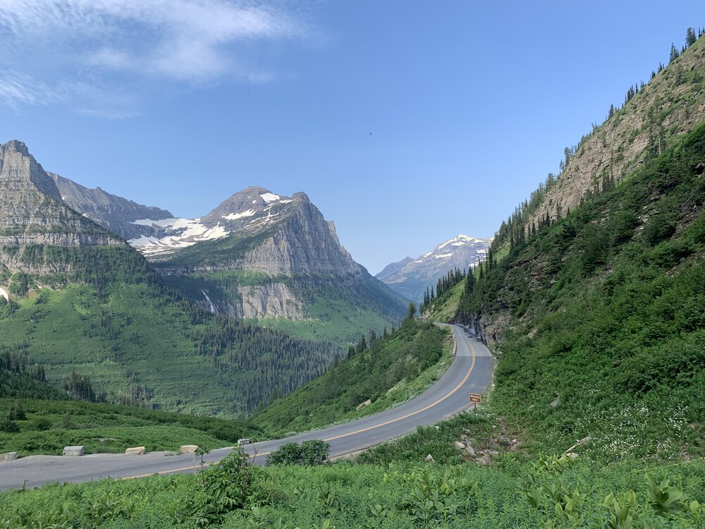
13 hours ago, gravitylover said:
You should have seen that spot 30 years ago when the glacier was a couple hundred feet thick in that bowl and spilled over the cliff down the gully above the waterfall. It was spectacular. The peak in the right background was completely covered with no rocks showing at all right down to treeline except for southerly spines in late summer where the rocks would show through. The difference is staggering to me
 I'm glad I saw it back when...
Kind of a nice day today. Not so great for outdoor stuff but in the same way it kind of was because it's so cool out. Ehh, saving on the AC so I'll take it.
In a few decades they'll have to rename that park to Puddle National Park.
-
Just now, LibertyBell said:
Roger, July 1993 had the most extreme and longest heatwave I've ever experienced....it was very cool and rainy (like yesterday) just a week before the heat came in, with a high/low of 66/62 on the 2nd, and a week after that we were in the middle of a 10 day heatwave, during which 100+ was reached 3 consecutive days (5 consecutive days at EWR, which includes two 105 days- their all time record at the time), we finished with a record 39 90+ days that summer and 20 of them in July!
The following winter we had that extremely cold and stormy 1993-94 winter (after we had our latest ever 80 degree high on November 15)....
-
Roger, July 1993 had the most extreme and longest heatwave I've ever experienced....it was very cool and rainy (like yesterday) just a week before the heat came in, with a high/low of 66/62 on the 2nd, and a week after that we were in the middle of a 10 day heatwave, during which 100+ was reached 3 consecutive days (5 consecutive days at EWR, which includes two 105 days- their all time record at the time), we finished with a record 39 90+ days that summer and 20 of them in July!
-
1979 and 1994 are the only ones on that list I've experienced and 1994 was a lot more snowy/icy than 1979 was and probably a lot more disruptive.
1968 is the only post 1940 year in the top 5.....
-
wow 1917-18 is unmatched by a wide margin....what was going on that winter?!
-
18 hours ago, bluewave said:
Probably the first year that a Memorial Day weekend and July 4th weekend had at least one day with such a cool max. All the more unusual when you consider that we had record heat before both weekends. Goes to the extreme wavelength changes that we have been experiencing over short periods of time.
Might be a pattern that repeats....look at my June-July 1993 comparison
-
18 hours ago, donsutherland1 said:
New York City’s (Central Park) < 60° Temperatures in July: 2000-2021
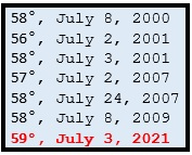
Don what about this morning? Looks like JFK made it to 59?
-
16 hours ago, JustinRP37 said:
This weather is so bizarre for July. 43 degrees colder than just a few days ago. Absolutely stunning.
Not that dissimilar to July 1993. We hit 95-96 right after the Summer solstice that year in late June right down to the coast, then we had a cool, breezy, rainy day on July 2nd when the splits were 66/62 and a week after that we were in the middle of one of the greatest heatwaves the area has ever experienced with 10 straight days of 90+ and 3 straight days of 100+ (and EWR had 5 straight days of 100+!) We ended up with the hottest summer we've ever had with 39 90+ degree days with 20 of them coming in July. July 2nd became a distant memory.....
-
1
-
-
12 hours ago, Nibor said:
"..." upper right corner "edit"
it's very nonintuitive it should be at the bottom right where the quote button is


July 2021
in New York City Metro
Posted
Thanks, Uncle, are 1953 and 1966 the only two years to have 100+ temps in multiple months?
1953 had it in 3, wow.