

LibertyBell
-
Posts
40,111 -
Joined
Content Type
Profiles
Blogs
Forums
American Weather
Media Demo
Store
Gallery
Posts posted by LibertyBell
-
-
23 minutes ago, bluewave said:
A combination of a warmer atmosphere holding more moisture and slower moving systems.
weird it's also happening in areas that are in megadroughts. It is the monsoon season though! Any reports of excessive reports out of the Asian monsoons?
-
Just now, bluewave said:
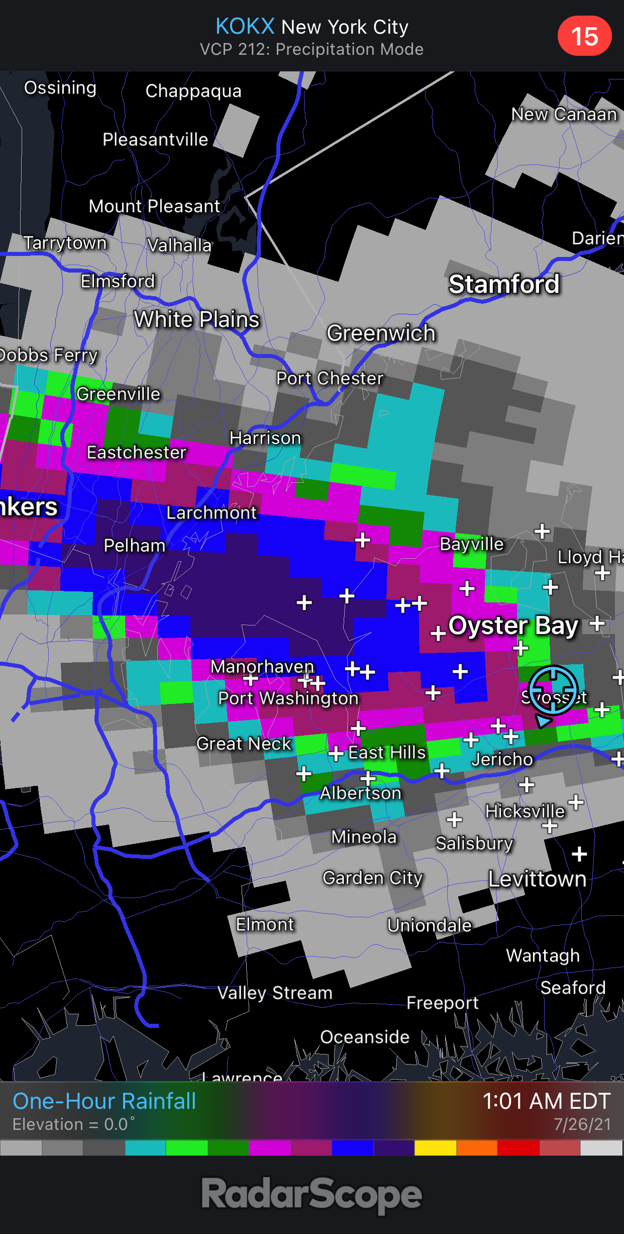
Another 2.31 on the North Shore with the thunderstorms last night. This brings the Port Washington total to 14.31 for July so far. This probably qualifies among the heaviest July rainfall totals recorded on Long Island.
NY-NS-27
Port Washington 0.8 N
Lat: 40.839167
Lon: -73.68025* indicates Multi-Day Accumulation Report Station NY-NS-27 Date Precip in. 07/01/2021 1.04 07/02/2021 1.12 07/03/2021 2.26 07/04/2021 0.79 07/05/2021 0.00 07/06/2021 0.00 07/07/2021 0.43 07/08/2021 0.01 07/09/2021 3.07 07/10/2021 2.06 07/11/2021 0.02 07/12/2021 0.21 07/13/2021 0.04 07/14/2021 0.02 07/15/2021 T 07/16/2021 0.00 07/17/2021 0.00 07/18/2021 0.28 07/19/2021 0.05 07/20/2021 0.01 07/21/2021 T 07/22/2021 0.34 07/23/2021 0.01 07/24/2021 0.00 07/25/2021 0.22 07/26/2021 2.33 Totals : 14.31 in. Several years ago, I remember the SW part of Nassau county had flooding rainfalls with a stalled storm in July, do you remember this Chris? Basements were flooded, and I believe JFK got between 4 and 5 inches of rain? This isn't the 10 inch deluge that happened here in August 2011, this was a much more localized event that only hit southern Queens and SW Nassau county.
-
32 minutes ago, bluewave said:
Yeah, these rainfall extremes are occurring all across the world. This is officially the wettest monsoon on record to date in Tucson. Also notice how the intensity of the monsoon produced the record cool temperatures in Phoenix.
Whats the cause of this sudden global rainfall increase all across the world, even in areas experiencing a super drought? It's almost like we have a monster storm circulating across the entire planet, our own version of the Great Red Spot.
-
31 minutes ago, donsutherland1 said:
Morning thoughts…
Today will become mostly sunny and very warm. Temperatures will rise to the upper 80s and lower 90s in most of the region. Likely high temperatures around the region include:
New York City (Central Park): 89°
Newark: 93°
Philadelphia: 93°
Normals:
New York City: 30-Year: 85.1°; 15-Year: 86.2°
Newark: 30-Year: 86.8°; 15-Year: 88.2°
Philadelphia: 30-Year: 87.7°; 15-Year: 88.7°
Tomorrow will be partly cloudy and hot.
With the downsloping wind, could JFK beat NYC in temps the next two days, Don, and get to 90+ both days?
-
1 hour ago, SnoSki14 said:
Not often you see 50s in the forecast during peak summer climo.
This is much more common 2nd half of August than late July.
Could this be signs of a developing El Nino?
We had very cool nights in August just prior and during the Perseid meteor shower back in the mid 80s just before an El Nino.
-
35 minutes ago, so_whats_happening said:
Maybe but probably overall an expansion in its coverage compared to what it use to be. For this you would have to look at the trends along the coastline are temperatures warmer overall? With overall warmer nights (inland) than days, days seem to be warmer in winter compared to days in summer, we can see how just a bit of added moisture can change our temperature records. I would be curious if moisture content has increased in areas that normally dont experience moisture on a regular basis like the west. I know it would be counterintuitive with more heat and forest fires out west to have more moisture in the air but it would be something of interest to check out at some point. Example: areas like phoenix when heat kicks in having dewpoints in the single digits (F) well now they are in the teens or twenties.
Maybe we are seeing a switch of the AMO?
Definitely along the coast too. Higher mins and some blunting of extremes of highs, but still warmer than normal overall. The added moisture makes it more difficult to achieve higher maximums but does raise the floor with the higher mins.
I noticed the added moisture in the West. One thing we need to remember is that added moisture in the air does not necessarily equate to more rainfall (it does in the East but maybe not in the West.)
-
19 minutes ago, Intensewind002 said:
I’m in Jericho, that storm was parked over us for a couple of hours. CG lightning was insane here, back home in Lindenhurst I would have probably been in the same boat as you lol
Funny how these storms always seem to do this. It's like a repeating pattern. Cant be a coincidence.
The electrical grid is so fragile here that a couple of distant lightning flashes takes the power down lol.
-
9 minutes ago, LibertyBell said:
How and why the hell does the rainfall always miss this area? See that area between Valley Stream and Oceanside lol? All we get is flashes of lightning and power outages, but no rain. What's the reason this happens?
We did have rain this morning but it was general stratiform rain (welcome though, especially without lightning, which I don't like seeing since it causes power outages here.)
Looks like absolutely nothing happened here, the moon is out and no signs of any clouds anywhere.
-
On 3/24/2021 at 5:32 PM, tamarack said:
Down to 13° at Central Park as the snow was ending. At our NNJ home we had a windblown 6" in 5 hours as the temp slid from 13 to 8, remarkable for so late in the season. (And minima the next 2 days were zero and -3; 10 and 8 a Central Park.) IIRC, the forecast for that clipper was 1-3 or 1-2, but it really grew up.
Latest 0 on record on Long Island was during that period.
-
19 hours ago, bluewave said:
This is the first time in the post 2010 era that Newark experienced such a big monthly maximum temperature drop from June to July.
Monthly Highest Max Temperature for NEWARK LIBERTY INTL AP, NJ
Click column heading to sort ascending, click again to sort descending.YearJunJulSeasonMean 96 100 +4 2021 103 97 -6 2020 93 96 +3 2019 93 99 +6 2018 96 98 +2 2017 99 98 -1 2016 91 99 +8 2015 93 98 +5 2014 92 96 +4 2013 96 101 +5 2012 99 104 +5 2011 102 108 +6 2010 98 103 +5 Shows how wonderful that 2010-2013 period truly was, I miss it!
-
19 hours ago, bluewave said:
This is the first time in the post 2010 era that Newark experienced such a big monthly maximum temperature drop from June to July.
Monthly Highest Max Temperature for NEWARK LIBERTY INTL AP, NJ
Click column heading to sort ascending, click again to sort descending.YearJunJulSeasonMean 96 100 +4 2021 103 97 -6 2020 93 96 +3 2019 93 99 +6 2018 96 98 +2 2017 99 98 -1 2016 91 99 +8 2015 93 98 +5 2014 92 96 +4 2013 96 101 +5 2012 99 104 +5 2011 102 108 +6 2010 98 103 +5 Was that back in July 2019 when JFK had the back to back 99 highs and the record 117 heat indices? I remember it was a Saturday and Sunday that happened.
-
20 hours ago, bluewave said:
With all the blocking, areas just N and W of NYC could see 50s next weekend.

Looks like we could be close to the upper 50s too
-
3 hours ago, uofmiami said:
1” to 1.50”/hr on KOKX. Yellow is 2”/hr rainfall on my RadarScope. Port Washington to Westbury are in line for that it seems.

How and why the hell does the rainfall always miss this area? See that area between Valley Stream and Oceanside lol? All we get is flashes of lightning and power outages, but no rain. What's the reason this happens?
We did have rain this morning but it was general stratiform rain (welcome though, especially without lightning, which I don't like seeing since it causes power outages here.)
-
2 hours ago, Intensewind002 said:
Pushing almost 2 hours straight now of heavy rainfall, lightning and thunder has calmed down a little but it’s still there
huh how are you getting that weird rainy weather when you're on long island just like I am? We just had a few flashes of lightning and no rainfall of consequence. We had enough of that this morning though.
-
20 hours ago, bluewave said:
With all the blocking, areas just N and W of NYC could see 50s next weekend.
I know this is way out there range, but I have plans to be in the Poconos for the Perseid meteor shower. I'm going there Saturday August 7th and will be there until Monday August 16th for the shower. Of course, no specifics can be given, but can you at least hint at some generalities like sunny, dry weather hopefully? And hopefully not humid or really hot either. 50s at night would be perfect. The other really good thing is the moon will be in the first half of its phase cycle so will be setting before midnight that week and not interfere with the Perseids!
-
2 hours ago, so_whats_happening said:
Lol you just dont read
This part needs to be reread:
We are still two days away from the heat just starting to enter the high arctic and with ridging over the area full sun will be out, yes with declining insolation each day but warm windy weather and sun is duo that even in our latitudes snow/ice melts out from this. Add in any moisture potential and the process really speeds up. There also seems to be a push from the american/canada region of ridging over the CAA with potential +2-4C anomalies showing up.
Ice thickness is about a lot more than just solar insolation. Meanwhile the glaciers are going bye bye all across the globe and people are fiddling while Rome burns (not that I ever liked the Roman Empire or its philosophy of conquest but that's for another day lol.)
-
4 hours ago, so_whats_happening said:
Understandable, i remember from college days of learning it was rather difficult to quantify exactly a precise percentage of cloudiness. Im sure it has definitely improved in the past ten years. I completely understand the whole quality control going on with instrument data, i work at BWI airport and they recently put in a new building which we think has definitely played a role in skewing our observations a bit, so as the faa figures out a better placement or way to confront this we sit gathering data which isnt always too far off but can be quite erratic at times.
Absolutely the dewpoints have been just dumb over the past 5-10 years. Quite the jump for sure compared to the 90s and 2000s where yes we did get some high dewpoints at times but more often was a dryish heat from my recollection.
This huge rise in dewpoints and rainfall, are the higher temperatures in the Gulf of Mexico and Atlantic to blame for this? It can't be anything else, with how our tropical season now starts earlier than it did before and how wet and humid our springs and summers have become.
-
2 hours ago, so_whats_happening said:
The only thing I can think of is Kyoto Protocal was enacted in 1997 but I dont believe it made strict cuts on anything just incentivized new cleaner technology paths instead of old paths. You would think we took another step down with the 15/16 el nino if the super nino struck up something. So at a loss with why there was a 8 year long reduction in cloud cover.
It must vary quite a bit from region to region, I can tell you on the east coast the opposite is happening and dew points and rainfall have been on a steep increase, which has led to an explosion of vegetation and allergy levels that last nearly year round now. Of course in the West the exact opposite has been happening
-
6 hours ago, bluewave said:
Hard to keep track of all the record flash flooding around the world. Luckily, the driver survived.
whats the bigger problem, the record flooding or the scorching droughts? and do you think all the cloud seeding going on is going to be enough to be enough to curb the worst of the droughts? I read that the most it can do is add back 20-25 pct of normal precip for a given region that's in drought conditions.
-
8 hours ago, bluewave said:
This would be a great winter pattern.
")


I guess that means that August heat is going to be canceled too
-
8 hours ago, stemwinder said:
Sheesh! Central Park is a great place. But that blows my mind. Probably economy and budget issues, cum bureaucracy at its worst. Pity the poor Mets who get blamed. No met for 60 miles.
they all moved to the suburbs- I do blame them for doing that
-
 1
1
-
-
11 hours ago, uncle W said:
in the 60's the question would be when was the last time NYC had four straight days with dew points above the 50's...
those must have been some amazing years
-
12 hours ago, nycwinter said:
when was the last time nyc had 4 days in a row in july with dew points that were in the 50's
earlier in the month lol. I think they were in the 30s and 40s?
-
12 hours ago, bluewave said:
I have never heard of an ASOS system being moved after it was built. The best time to have done that was before they installed it back in 1995. I don’t think there is a budget for moving weather stations.
a better idea might be to have a back up weather station installed elsewhere in the Park (like in the Sheep Meadow) and use that data to correct the other one. Of course installing a second unit there would require $$$$$
Why did we switch to ASOS? The old way was more accurate. Automation = laziness.


August 2021
in New York City Metro
Posted
what did we have in 2001? I remember that summer as cool and wet and somehow we spiked up to 103 in August (second highest temp ever recorded in August)?! and went back to cool and wet again after that? The heat didn't come back until November and then never left again until over a year later lol.