thomp2mp
-
Posts
138 -
Joined
-
Last visited
Content Type
Profiles
Blogs
Forums
American Weather
Media Demo
Store
Gallery
Everything posted by thomp2mp
-
snow starting in Waterford
-
freezing rain now in Waterford, starting to accrete
-
Winter 2022/23 Medium/Long Range Discussion
thomp2mp replied to Chicago Storm's topic in Lakes/Ohio Valley
shades of March 2012... -
Midwest/Ohio Valley/Great Lakes Snow January 24-26
thomp2mp replied to Baum's topic in Lakes/Ohio Valley
Ended up with 6.5" in Waterford. ~1/4sm visibility on my way into work at 5:30am, just ripping. Then an exciting drive home around 2pm with ginormous flakes. So many curvy roads, my butthole was puckered on a few occasions. Very pretty though. -
Winter 2022/23 Short/Medium Range Discussion
thomp2mp replied to Chicago Storm's topic in Lakes/Ohio Valley
TO BE FAIR we moved into our house two months ago yesterday, and once I blew the leaves off it was way more green hahahahaha joking aside i will probably kill this lawn more than our current winter will. i haven't done anything but step on it occasionally and it looks better than when we moved in. -
2023 Short/Medium Range Severe Weather Discussion
thomp2mp replied to Chicago Storm's topic in Lakes/Ohio Valley
Severe T-Storm warnings issued for parts of Seneca, Wyandot, and Hancock counties in NW Ohio. Sucks that there is such a radar hole in this area. Even the TDWRs are distant. -
Pre-Christmas (Dec 21-23rd) Winter Storm Part 2
thomp2mp replied to Chicago Storm's topic in Lakes/Ohio Valley
the condensation trail from everyone collectively sighing because they live in the dakotas -
Pre-Christmas (Dec 21-23rd) Winter Storm Part 2
thomp2mp replied to Chicago Storm's topic in Lakes/Ohio Valley
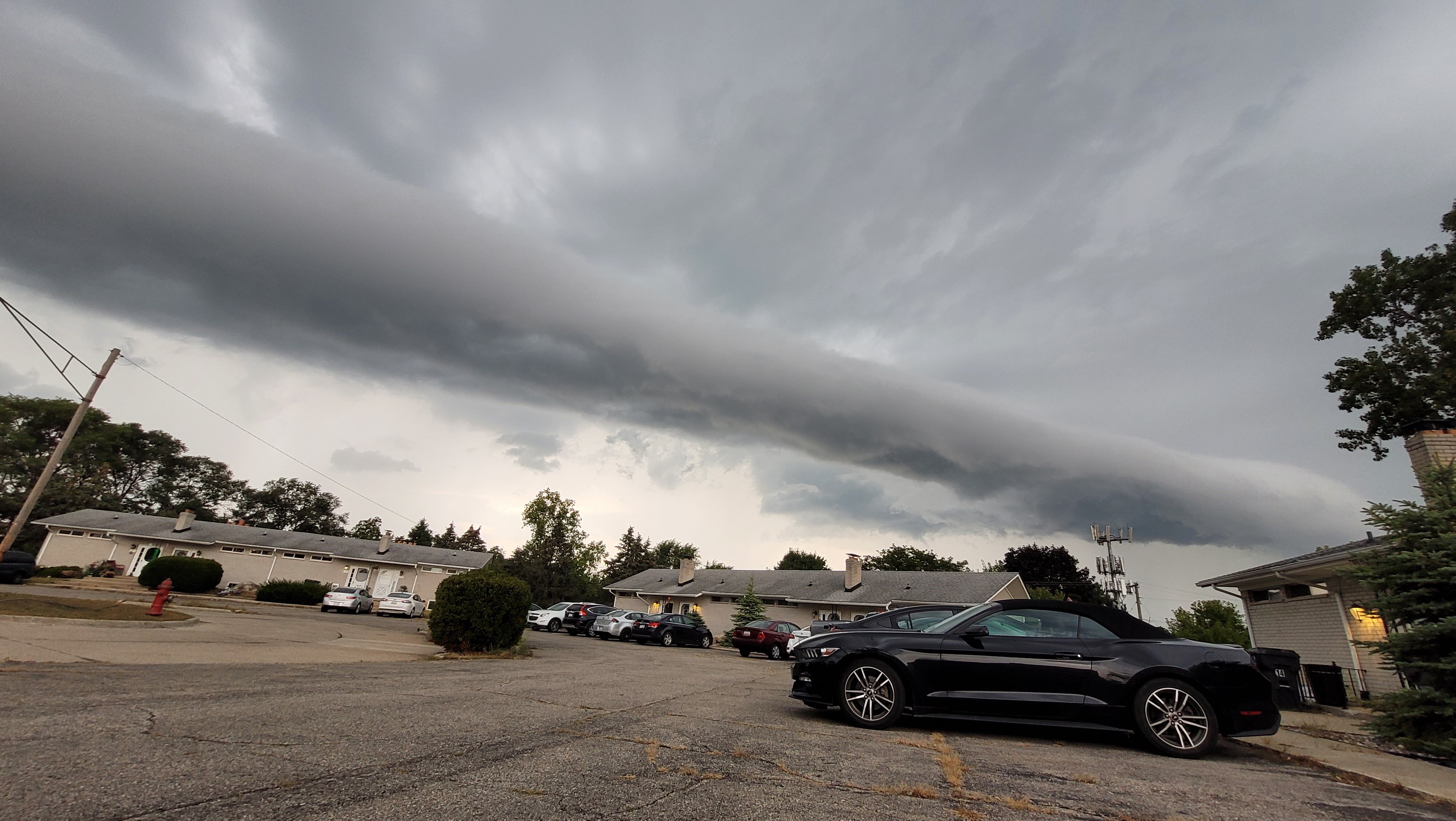
Still a rainstorm here in Waterford. Big ol' cold drops. Gonna wake up to a windy sheet of ice with a fondant of crust flakes -

-
ORD 75° and MDW 74° in 2020. Seems possible.
-
one that starts when I get home from work and stops with enough time for the road crews to work their magic for the next day of work or, a crippling weekend storm that I can use as an excuse to hibernate for a couple days
-
2022 Short/Medium Range Severe Weather Discussion
thomp2mp replied to Chicago Storm's topic in Lakes/Ohio Valley
1.63" of rain here since 6PM. transformer blew up so our power has been out since 6:30. winds weren't too extreme. hope the power comes back on. jeopardy might not be recording on the dvr -
Summer 2022 Medium/Long Range Discussion
thomp2mp replied to Chicago Storm's topic in Lakes/Ohio Valley

-
2022 Short/Medium Range Severe Weather Discussion
thomp2mp replied to Chicago Storm's topic in Lakes/Ohio Valley
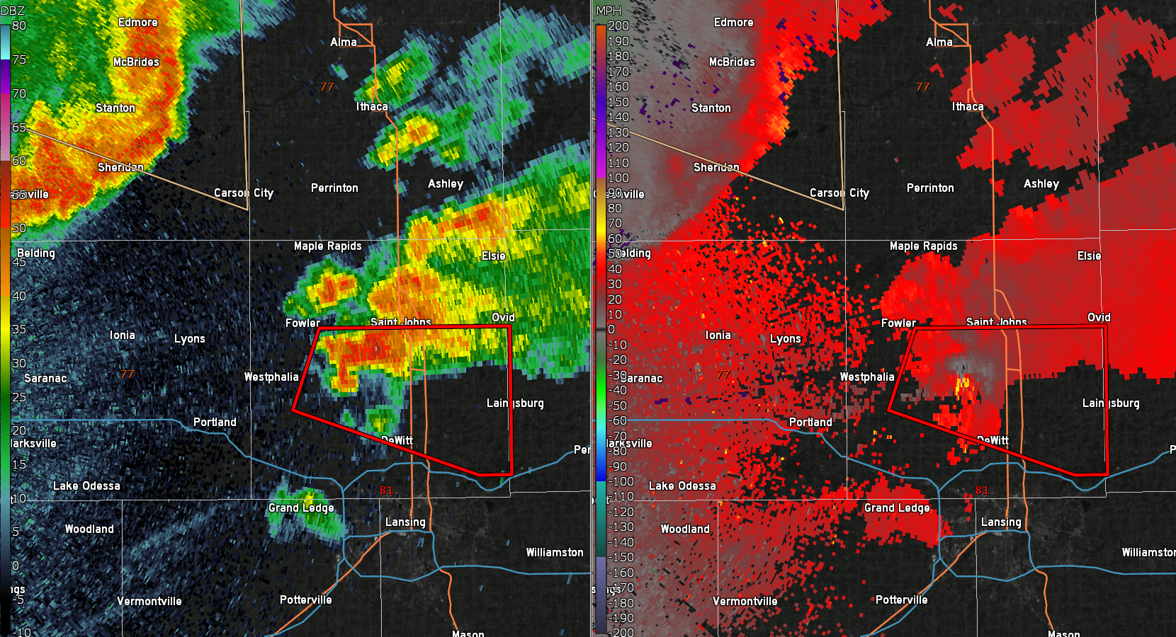
TOR warned storm between DeWitt and St. Johns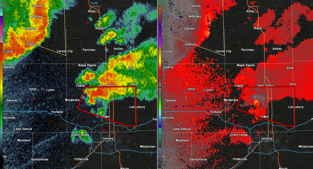
-
Severe T-Storm Watch 356 expanded northward into Central Lower MI, including Grand Rapids and Muskegon
-
https://twitter.com/CollinGrossWx/status/1536491040110264324?s=20&t=p5a7oU6GnsHj5u4CeoV0Kg
-
2022 Short/Medium Range Severe Weather Discussion
thomp2mp replied to Chicago Storm's topic in Lakes/Ohio Valley
the Mitten, omitten -
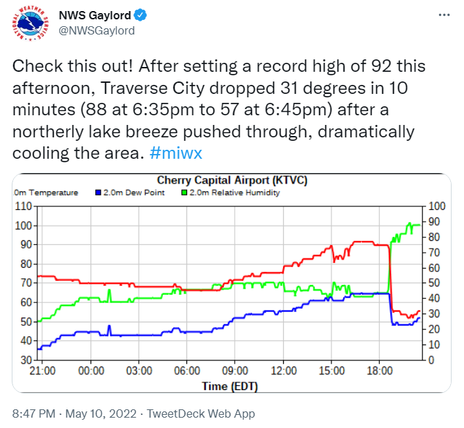
Northern Lower Michigan just torched today. Record highs set today: Traverse City: 96° (86°, 1944) also the highest temp recorded in the month of May Pellston: 91° (87°, 2004) Gaylord: 90° (84°, 1991) Alpena: 89° (87°, 2004) Houghton Lake: 87° (tied, 1991) Other MI records toppled: MBS: 88° (86°, 1991 GRR: 87° (86°, 1896) Muskegon: 91° (83°, 2011)
-
Did you guys see that Traverse City hit 92° yesterday?
-
Wow Alma at 56/19 and Benton Harbor at 59/56
-
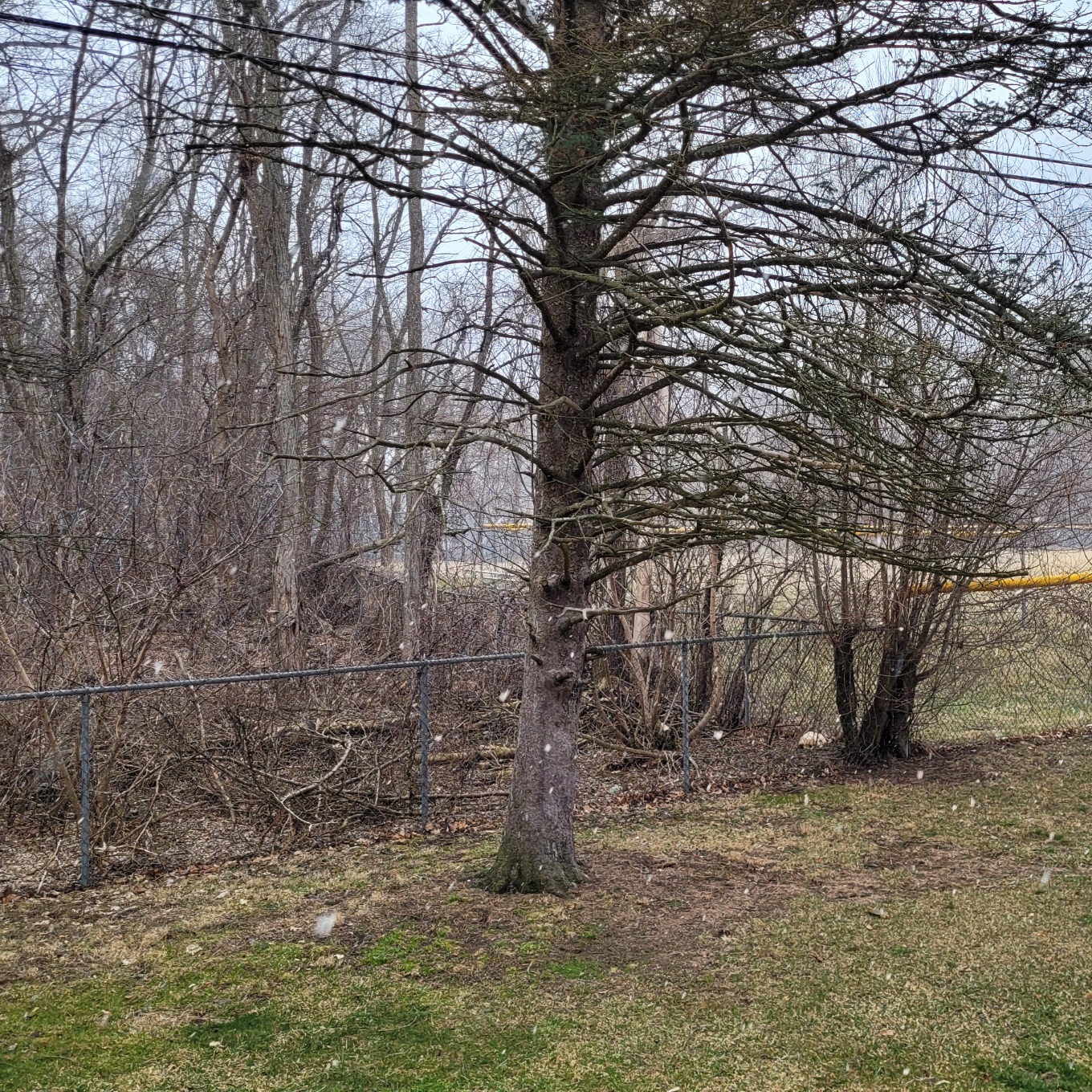
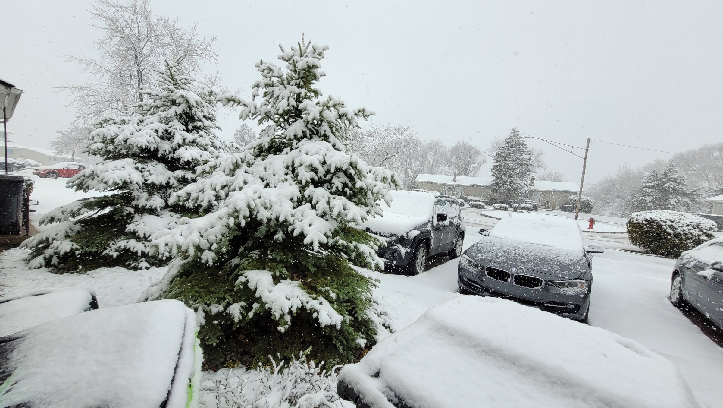
solid 2" of paste here. nice embedded squall just came through. main roads are slushy and back roads mostly snow covered. sitting at 35°

-
DTX has issued WWAs for the Thumb for 3-6", and Macomb and Oakland Counties for 2-4"
-
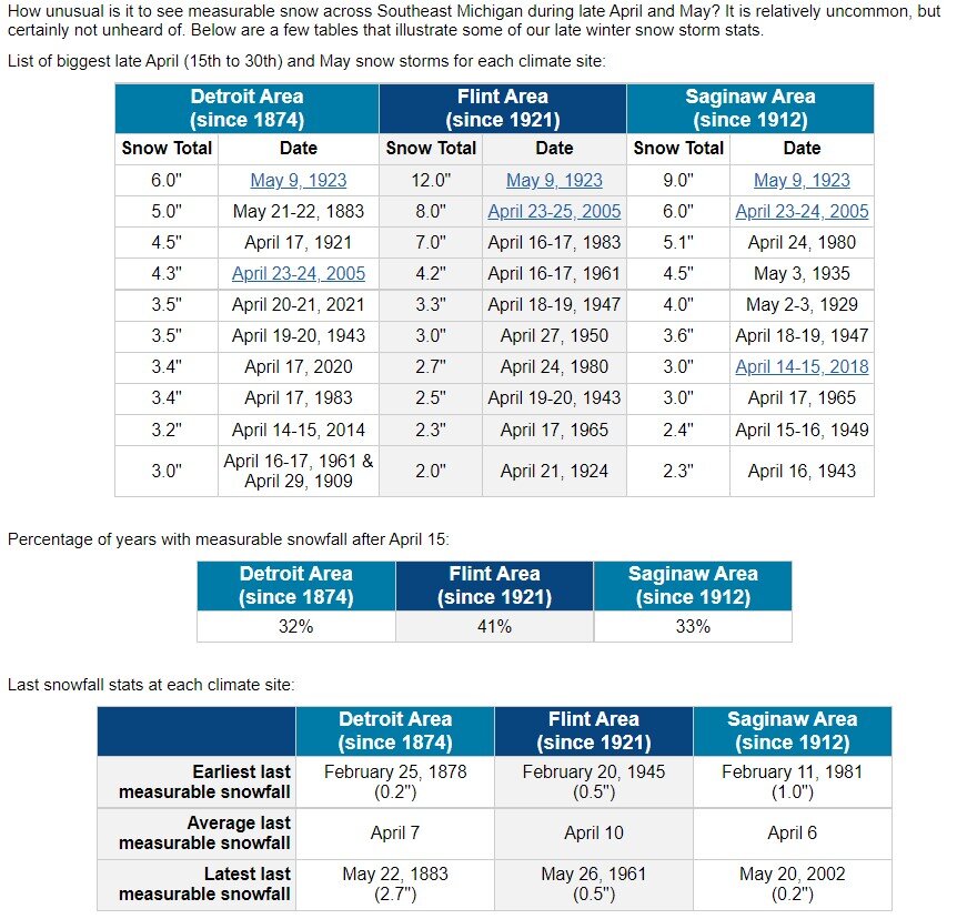
stats from DTX on late season snowfall

-
71° imby, first 70° day since March 18th, and first day in April above 60°. Clouds are starting to roll in though.
-
2022 Short/Medium Range Severe Weather Discussion
thomp2mp replied to Chicago Storm's topic in Lakes/Ohio Valley
OHDOT traffic cam at I-75 and US-36 pointed south