

psv88
-
Posts
13,992 -
Joined
-
Last visited
Content Type
Profiles
Blogs
Forums
American Weather
Media Demo
Store
Gallery
Posts posted by psv88
-
-
6 minutes ago, Edubbs83 said:
In commack on LI? Raining here in Jericho
Yup all snow
Took photo but can’t post for some reason. Says too large
-
started as snow here. Nice steady snow. Good to see. Not sticking yet but who cares
-
-
3 minutes ago, NJwx85 said:
Here you go, they don't have a nice zoomed in one that shows LI. I believe the guy that owns the website is PA centric.

TY. First one of those ive ever seen for the whole NE
-
7 minutes ago, NJwx85 said:
06z Euro

Do these maps not show LI and CT? I dont understand why only PA and NJ are posted from these maps every time.
-
 1
1
-
-
15 minutes ago, Stormlover74 said:
We're in the colder pattern right now. Its just nothing severe and it looks to be dry for the foreseeable future
Eh, colder than before yes. Highs in the low to mid-30s are rather typical for mid-January. I can't remember a snowless stretch this long before. Its been 2 months since weve seen measurable snowfall. Other than the cold wind which arrived today, its felt like spring
-
8 hours ago, Snow88 said:
I'm going next month
Free room at Tropicana =)
Aren't all of the rooms at the Tropicana free now?
-
1 hour ago, bluewave said:
Kind of disappointing that the new version isn’t much better than the old one. There could be implementation delays with the govt shutdown.
https://mobile.twitter.com/RyanMaue/status/1081270401727193088
https://mobile.twitter.com/RyanMaue/status/1081268461756661761
Word is the new one is only slight better.
-
1
-
-
Doesn’t feel like winter. Hasn’t snowed in what, 45 days? I’m already ready for summer.
-
4
-
-
Winter 2018-2019, an exercise in moving goal posts. (2011-2012 sends it’s regards)
-
 2
2
-
-
60 degrees
-
1
-
-
Nice dusting of snow!

-
2
-
2
-
-
8 hours ago, NorthShoreWx said:
I was an organized little bugger. Maybe explains why I am a project manager now.
There was no internet so you had to write things down if you wanted to refer back to them.
That is impressive.
-
32 minutes ago, NorthShoreWx said:
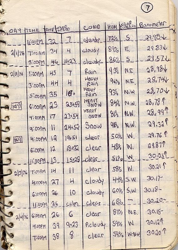
Positive. Here is a handwritten log with a few observations from central park for that event on 2/2/1976.
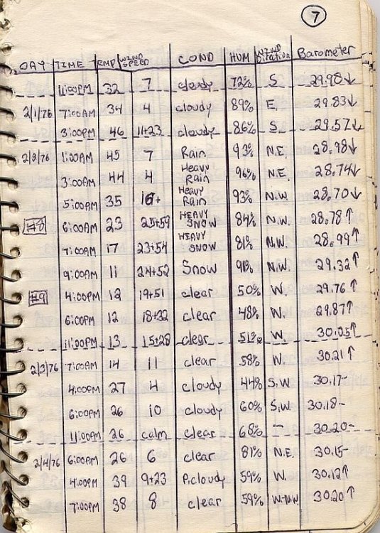
Is that your log?
-
29 minutes ago, NJwx85 said:
I remember how warm last January and February were and a lot of people including myself thought that Winter was over and that it was going to be a very early Spring and then March happened and even though the immediate coast didn't see as much snow as I did, it had more to do with storm track rather than sun angle or climo.
Pretty sure the coast, at least out this way, had a 12+" event last March...
-
35 minutes ago, snowman19 said:
Thank you Don. I didn’t look up the actual data but I knew such a scenario was not only unlikely but an extremely rare feat. Even if extended 3 more weeks to 3/21, an extreme rarity still I’m sure
Last winter Suffolk County had 3 legit 12"+ blizzards, and many spots were over 70" of snow. I am not sure how that stacks up in history, but the point is anything can happen. 40" in 6 weeks, i dont see why not. Islip recorded 5" in one hour, and 9"of snow in 2 hours last year. With those numbers, anything is possible.
-
1
-
-
2 hours ago, purduewx80 said:
Not true considering that JFK and LGA are on LI.
Geographically yes. When discussing weather in the area no. For example, read Uptons AFDs. Even last night they referred to immediate NYC metro vs Long Island (which worked out well). When discussing weather, immediate nyc metro includes queens and bk, while LI refers to Nassau and Suffolk.
But thanks for pointing that out for me, I’ve only lived here for 34 years.. I always thought there was a river on the Nassau queens border.
-
1
-
2
-
-
5 minutes ago, purduewx80 said:
EWR is the only immediate NYC-area station to have observed snow overnight (-RASN). NYC, LGA, JFK only reported light rain.
All of the LI stations reported snow at one point
-
36 and snowing
-
27 minutes ago, NJwx85 said:
Northeast NJ rivers are in big trouble.
Wanaque reservoir is running 1-2’ over the spillway and steadily rising.
Rain is done for NE NJ
-
45 minutes ago, bluewave said:
2.05” at Stony Brook.
Up to 60" for the year. Notwithstanding that we a had dry spell this summer where everything was brown
-
1
-
-
Up to 2", flooding abound here
-
Fire hose setting up for Nassau and Western Suffolk.
-
Flash Flood Warning
NYC059-103-211845-
/O.NEW.KOKX.FF.W.0055.181221T1547Z-181221T1845Z/
/00000.0.ER.000000T0000Z.000000T0000Z.000000T0000Z.OO/

BULLETIN - EAS ACTIVATION REQUESTED
Flash Flood Warning
National Weather Service New York NY
1047 AM EST FRI DEC 21 2018

The National Weather Service in Upton NY has issued a

* Flash Flood Warning for...
  Western Suffolk County in southeastern New York...
  Eastern Nassau County in southeastern New York...

* Until 145 PM EST.

* At 1044 AM EST, Doppler radar indicated heavy rain across the
  warned area. Up to one inch of rain has already fallen. A band of
  heavy rain, oriented north to south over the Atlantic Ocean, is
  estimated to be producing one hour rainfall rates of 1 to 1 1/2
  inches and is moving onshore. Flash flooding is expected to begin
  shortly.

* Some locations that will experience flooding include...
  Islip, Brentwood, Levittown, Commack, Huntington Station,
  Centereach, Deer Park, Lindenhurst, Plainview, Massapequa,
  Hauppauge, Ronkonkoma, Syosset, Huntington and Stony Brook.

PRECAUTIONARY/PREPAREDNESS ACTIONS...

Please report flooding to your local law enforcement agency when you
can do so safely.

A Flash Flood Warning means that flooding is imminent or occurring.
If you are in the warned area move to higher ground immediately.
Residents living along streams and creeks should take immediate
precautions to protect life and property.

&&

LAT...LON 4058 7358 4095 7349 4091 7342 4096 7339
      4091 7322 4093 7316 4097 7317 4098 7312
      4097 7299 4074 7300 4065 7337 4067 7324
      4065 7321 4067 7321 4070 7300 4068 7300
      4062 7323

January 19-20th Winter Storm Threat
in New York City Metro
Posted
Here we go