

psv88
-
Posts
15,661 -
Joined
-
Last visited
Content Type
Profiles
Blogs
Forums
American Weather
Media Demo
Store
Gallery
Posts posted by psv88
-
-
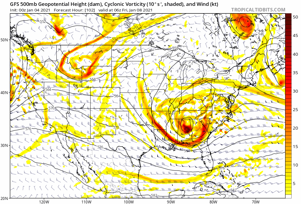
Euro 20+” all the way into northern suffolk. Nothing like seeing the best model have the snowiest run during the storm.
-
 4
4
-
-
Coming down nicely in NW Suffolk, solid coating, maybe 1/2”. Excellent snow growth
-
5 minutes ago, jm1220 said:
Yup, we should do very well. Not the jackpot but best event since possibly 3/21/18. I'd say 80-90% chance we at least get into double digits.
100% chance we get into double digits. Model consensus for our area hasn’t wavered in days. It’s been a pretty boring lead up honestly, models always showed us in the game for 12”+.
-
 1
1
-
-
19 minutes ago, jm1220 said:
That said it's the most amped of the models with it and other models like the NAM have the mid level features a bit to the east. However a fast dry slot is always a threat when the 700 low goes west of you.
This isn’t a Suffolk special, this setup favors NJ. We will get over a foot for sure, especially your area.
-
2
-
-
1 minute ago, justinj said:
The weather channel forecast has Islip airport turning to complete rain lol
It might at the end
-
20 minutes ago, SnowGoose69 said:
When I said days ago I would rather be in NYC than SNE I did not mean it for the reason it may transpire lol...the way the system tracks trying to make the appearance of an exit and then taking the north hook or turn like 3/2013 could allow warmer air to make enrodes there faster/more west. My initial concerns were the jackpot of snow would simply be SW of them
This. The storm has changed markedly in the past 48 hours. Happens
-
18 minutes ago, HVSnowLover said:
Ok I stand corrected euro is not a rain threat but it still looks like it ticked a bit NW
Don’t stand corrected. There are eastern posters who will flip to rain. Western posters will not. It’s ok to analyze the storm for eastern areas.
-
35 at FRG and 33 at ISP with a mix, interesting variation across the island, south of the LIE generally above 32, north of the LIE generally below 32...temp continues to drop here despite the snow lightening up.
-
1
-
-
2 minutes ago, NorthShoreWx said:
We keep getting little bursts of heavier snow with nice well formed flakes. Temp has also dropped slightly below freezing after being a degree or two above all day and the snow that was having trouble sticking to the grass is now starting to stick to the pavement. There does appear to be some ocean enhancement going on.
Finally dipped below freezing here as well, and yes, best snow growth of the day
-
32.9 and snow in suffolk, looks like ocean effect! Bands now moving east to west, this stuff is really piling up!
-
1
-
1
-
-
This winter sucks. This is terrible
-
30 minutes ago, Rjay said:
What a mess lol

Good luck with that
-
1
-
-
-
-
1 hour ago, MJO812 said:
Who the hell wants 60s during the winter?
Everyone
-
2
-
1
-
 3
3
-
-
1 hour ago, MJO812 said:
Better than 50s and 60s lol
I remember one NYE I ate outside in short sleeves with my dad on NYE.
How is a cold rain better than 60s?
-
2
-
-
Didn’t seem too bad here on the island. Upper 50s, so nothing we couldn’t handle
-
3
-
-
3 minutes ago, nycsnow said:
Most models show some gust 50+ starting 10 or so let’s see there’s a lot of 35-40s starting to pop up
Starting to gust 35 or so out here, steady roar now.
-
2
-
-
Just now, nycsnow said:
Just finished dinner waiting on dessert and the winds! The sustained winds are so far more impressive then gust atm
Highest winds aren’t for another 7 hours
-
1
-
-
46 minutes ago, NorthShoreWx said:
Approx a 10 - 12 degree difference between the north shore and south shore tonight. Below freezing all evening here (30 now and slightly rising) and the snowpack is fully refrozen. Southerly wind off the water has south shore in the low 40s. Nightime thaws are the death of snowpacks (one of the main reasons NYC can't keep a snowpack), but in 24 +/- hours it won't matter as the annual Grinch storm will be raging.
The Catskills are going to take a big hit with snowmelt, rain and flooding. It's a shame that they'll have to reset too; it was fantastic when we snowshoed the bushwhack range on the solstice on Monday:
https://photos.app.goo.gl/ZmsYCNkQKqah6hQF9
29 here with a stout snowpack
-
2
-
-
6 hours ago, Cfa said:
Snowpack gone, except in the shadiest areas.
Wow. Full snow cover here.
-
2 hours ago, wdrag said:
Good Monday morning everyone, Dec 21- The first day of astronomical winter! This topic remains (somehow) on target!
I am 70% confident of damaging wind and power outages part of our forum area within about 3 hours midnight Christmas eve-morning, gusts possibly to 65 or 70 MPH on LI in a HSLC (High Shear Low Cape) band of convection (thunder may not occur but I suspect SVR's may need to be issued or some sort of wind warning). Did not add the widespread 50 MPH ECMWF gust graphic... suffice it to say, it's been consistent on 50+ for our forum... just cyclically varying it's tracking 70+ between se MA and LI.
Flooding: Please follow NWS statements on this situation when they are issued. I've added a couple of graphics that show river concerns *yellow* = action consideration and then various color scales for subsequent flood POTENTIAL. This is qpf based so snow melt will also need to be considered as an addition. Snowmelt doesn't happen all at once: It happens faster in high dew point wind driven air overriding the snow pack, and the rain at first is absorbed by the snow then starts it's melting and release. So, nothing is automatic, guaranteed, instant. I didn't take a look at the individual gaged streams to see the graphing of rainfall and river stage plumes. The point: flooding potential exists. I'm not sure if it can happen on more than 3 or 4 rivers in our forum area (delayed river flood response may be til the 25th morning) and then much colder temps may lock in some of the runoff. Widespread 1-2" is expected in 9 hours, with potential for narrow bands of 3-4" in the interior preferred upslope areas...maybe this time CT? 6A/21


Upton mentioned the flooding potential too. @bluewave has been on this for a week. Posters such as @JoshSnow and @jfklganyc owe him an apology.
good work as always Walt, thank you
-
Snowing at a good clip and temp down to 33, coating in car tops etc. nice surprise
-
 1
1
-
-
20 minutes ago, jm1220 said:
Just measured again, have a little under 8”. This little weenie band on 25A is close by, hopefully it can come through.
Similar to my numbers, nice. East Northport trained spotter reported 8”. East Northport is the town next to mine so numbers are confirmed. 8” was the low end of our warning but it still verified the NWS forecast and snow continues.
-
1
-


Obs and nowcast Major Nor'easter near blizzard Sunday afternoon Jan 31 - Sunrise Wednesday Feb 3
in New York City Metro
Posted
Getting smacked under these ocean bands. Massive flakes.
love seeing the NAM give LI 30”. Wow