Round Hill WX
-
Posts
494 -
Joined
-
Last visited
Content Type
Profiles
Blogs
Forums
American Weather
Media Demo
Store
Gallery
Everything posted by Round Hill WX
-

Jan 31st - 33rd Storm Obs and Disco like it's 1979
Round Hill WX replied to Bob Chill's topic in Mid Atlantic
Picked up 1.5” since 330p. Storm total 7.5” in Round Hill. Cleared the snow board and will check again in the morning. Been an enjoyable couple of days. -
Jan 31st - 33rd Storm Obs and Disco like it's 1979
Round Hill WX replied to Bob Chill's topic in Mid Atlantic
It's been snowing lightly all day in Round Hill. Up to 6" total. Love the look of the radar. I just got into the band swinging down from the north...the earlier filtered sun through the clouds is gone and flake size has increased. 29/28 -
Jan 31st - 33rd Storm Obs and Disco like it's 1979
Round Hill WX replied to Bob Chill's topic in Mid Atlantic
Multiple Mets have already explained this to him. Tx -
Jan 31st - 33rd Storm Obs and Disco like it's 1979
Round Hill WX replied to Bob Chill's topic in Mid Atlantic
I have no idea how to post it....but check out KDOX radar. It’s absolutely beautiful to watch an exploding coastal. -
Jan 31st - 33rd Storm Obs and Disco like it's 1979
Round Hill WX replied to Bob Chill's topic in Mid Atlantic
Below is last nights 0z EURO you reference valid up until 0z tonight. It absolutely nailed my area so I don’t know what you’re referring to. Also, you originally posted a EURO from 6! days ago. Why you’re moving the goalposts from 6 days ago to last nights run is interesting. You’re still wrong but I’ll leave you to learn why.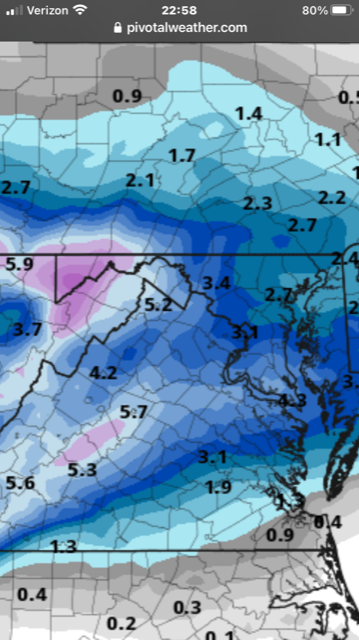
-
Jan 31st - 33rd Storm Obs and Disco like it's 1979
Round Hill WX replied to Bob Chill's topic in Mid Atlantic
Considering that model run initiated 6 days from the event and was only off by 150 miles, I would consider that pretty damn good. If you think it sucks, just ignore the EURO from here on out and you’ll be good. And hit up Howard, you guys will be good buds. -
Jan 31st - 33rd Storm Obs and Disco like it's 1979
Round Hill WX replied to Bob Chill's topic in Mid Atlantic
Got a new snowblower a couple weeks ago and was excited to fire it up. I took the kids sledding and when we returned my driveway was cleared. My neighbor, who is a great guy, used his blower to clear it. I was kinda bummed but figured I’d hit my elderly neighbors driveway after having something to eat. When I went back out to do it, another neighbor had done his driveway. So my new snowblower sits. Maybe tomorrow there will be enough snow to use it. 28/27 and 4.50” in Round Hill. Enjoy the snow everybody! -
Jan 31st - 33rd Storm Obs and Disco like it's 1979
Round Hill WX replied to Bob Chill's topic in Mid Atlantic
You're in a good spot...that band has set up nicely over you and is model to sit for awhile. -
Jan 31st - 33rd Storm Obs and Disco like it's 1979
Round Hill WX replied to Bob Chill's topic in Mid Atlantic
Don't tell him I ate his tasty cousin this morning. 28/28 and 2.75" in Round Hill. A great Sunday morning. -
Jan 25th Wintry Mix Obs and Nowcasting
Round Hill WX replied to stormtracker's topic in Mid Atlantic
This batch is back to sleet and freezing rain. 30/28 in Round Hill -
Jan 25th Wintry Mix Obs and Nowcasting
Round Hill WX replied to stormtracker's topic in Mid Atlantic
All snow now in Round Hill. 31/28 -
Jan 25th Wintry Mix Obs and Nowcasting
Round Hill WX replied to stormtracker's topic in Mid Atlantic
Starting as RAIN in Round Hill. 33/27 -
Jan 25th Wintry Mix Obs and Nowcasting
Round Hill WX replied to stormtracker's topic in Mid Atlantic
I noticed this as well...tons of lightning all day. -
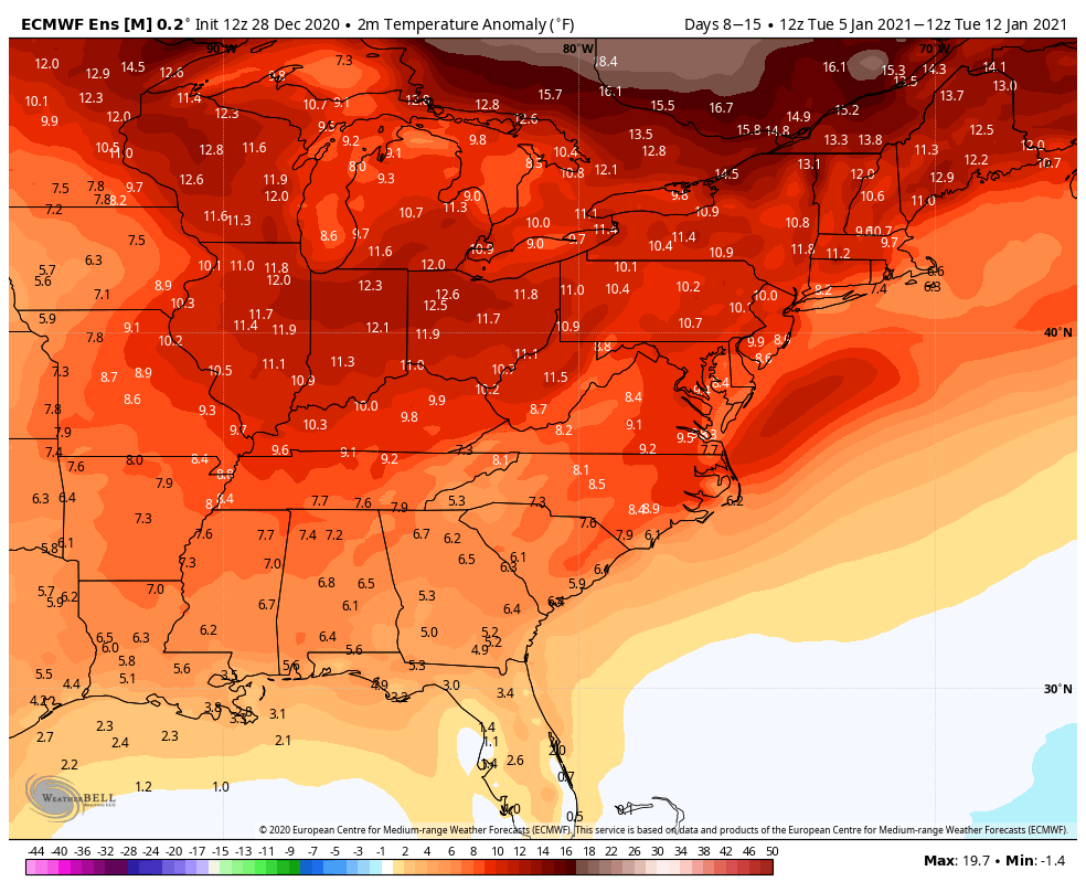
You mean to tell me that analyzing a day 7 EURO control ensemble 850 temperature map is over doing ?!?
-
Had a trash can topper in Round Hill...sadly it will likely be the greatest/only snowfall for the month of January.
-
Feb Long Range Discussion (Day 3 and beyond) - MERGED
Round Hill WX replied to WinterWxLuvr's topic in Mid Atlantic
FWIW at 354 hours, I agree with you. There is a hint at a inter-mountain west ridge that could spawn a NS LP to amplify over the Plains. However, that west-based -NAO will destroy anything coming east. Also, the Gulf and Atlantic moisture supply is shut off. Totally NS dominate.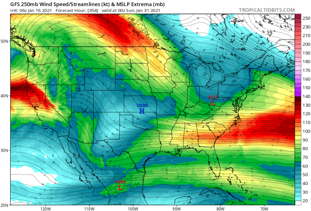
-
Got the 1st Moderna shot on 12/31. Due for the 2nd shot on 1/27. Outside of the standard sore arm, I had a bit of tiredness the next afternoon but nothing crazy.
-
The roads are icy. Saw a bunch of crashes on my way into work.
-
Initially, this -NAO is a bootleg. Typically it can help tap cold continental Canadian air. Right now the cold air is on the other side of the NH. Here is the result. Gonna probably have to wait.
-
December 16-17, 2020 Winter Storm Obs/Nowcasting
Round Hill WX replied to WxUSAF's topic in Mid Atlantic
Final total in Round Hill: 7” snow/sleet and a glaze of freezing rain. Great for December. -
December 16-17, 2020 Winter Storm Obs/Nowcasting
Round Hill WX replied to WxUSAF's topic in Mid Atlantic
This last batch has been sweet because of the wind. Snow blowing all over. I really enjoyed this storm...had around 6” of snow, sleet, freezing rain that looks cool on the Christmas lights, sleet again, and now back to blowing snow. I love all snow but there is nothing better than December snow before Christmas. -
December 16-17, 2020 Winter Storm Obs/Nowcasting
Round Hill WX replied to WxUSAF's topic in Mid Atlantic
Back to legit snow in Round Hill. Lost my direct TV satellite signal. 26/25 -
December 16-17, 2020 Winter Storm Obs/Nowcasting
Round Hill WX replied to WxUSAF's topic in Mid Atlantic
Agree and the NAM did a nice job with mid level thermal profiles. As usual. -
December 16-17, 2020 Winter Storm Obs/Nowcasting
Round Hill WX replied to WxUSAF's topic in Mid Atlantic
Good OB. The correlation coefficient showed a clear line pass by you a few minutes ago. Would imagine the rest of us out west switch back soon. -
December 16-17, 2020 Winter Storm Obs/Nowcasting
Round Hill WX replied to WxUSAF's topic in Mid Atlantic
Round Hill 5.0” 26/25 just began mixing with sleet. The last hour was 2” rate/hr. Really fun.