NJwx85
Members-
Posts
19,663 -
Joined
-
Last visited
About NJwx85

Profile Information
-
Four Letter Airport Code For Weather Obs (Such as KDCA)
KHPN
-
Gender
Male
-
Location:
Clarkstown, NY
Recent Profile Visitors
13,907 profile views
-
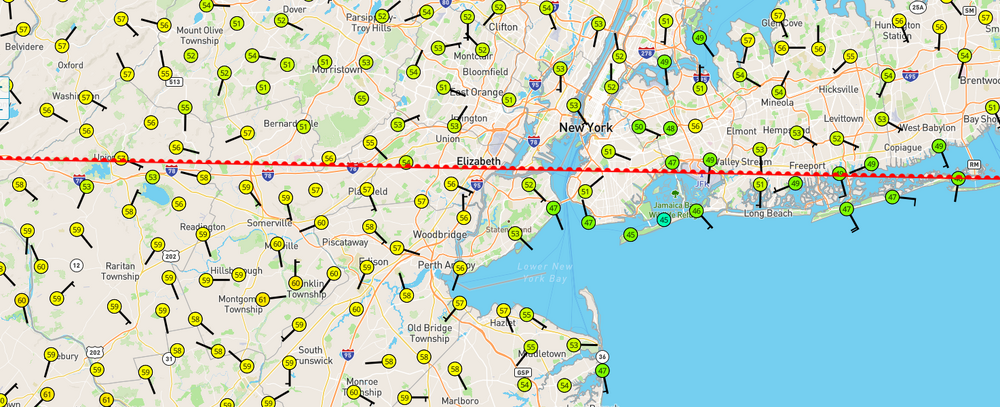
Up to 68 in Perth Amboy and most of coastal Monmouth County and Western Staten Island now pushing 70 degrees. Meanwhile Coney Island and the rest of the Long Island barrier islands are stuck in the mid to upper 40's. The warm front is into central New England but the wind is mostly Southerly. Some surface based instability is building just to our SW. I know the HRRR isn't particularly enthusiastic East of Morristown, but there is potential for a quick spin up ahead of the main squall line.
-
Not sure where exactly you're located, but Toms River is definitely on the Eastern edge of the threat area, hence the tornado watch.
-
Currently 64 in Keansburg with a Southerly wind, and 45 in Sea Bright with wind off the ocean.
-
I grade this Winter an A. It started off with multiple accumulating snow events in December, followed by a 20"+ snowfall in January and another double digit snowfall in February, with a few smaller events mixed in. The last of my snowpack didn't melt until the 80's last week, some of it still left from the January storm. We also had multiple episodes of brutal and lasting cold. Best winter locally here since 2019. Now it's time to put away the shovels and get ready for Spring. My crocuses are already popping up.
-
If the warm front is able to lift a bit further North, today could be a significant severe weather day, especially West of the Hudson. You can easily see here where the wind shift is and why storms should weaken as they get close to the city.
-
We deserve a nice, warm, early Spring after the brutal Winter we have just endured. Yes, it snowed a lot, which was fun at times. There were also periods of brutal, bone chilling cold and dry weather and more ridiculously windy days than I can count.
-
This year it's over. I'm not saying that it won't cool down after the incoming torch but there won't be anymore snow after next week, especially near the coast.
-
It's over, and thank F*cking God for that.
-
After the threats this weekend and early next week, things really warm up. Both the GFS and Euro really pump up the Bermuda ridge. We could be looking at lower 70's outside of Long Island for an extended stretch beginning the end of next week.
-
I’m closing in on 18” here now. Decent chance I get over 20”. That band looks parked. HRRR has it sticking around another 2-3hrs.
-
I’m under a solid band now. Heaviest snow here since dawn.
-
The way it was coming down around midnight I thought for sure I’d wake up to about double what we got.
-
I wonder if that band is going to make it here or if this it. Stuck under subsidence.
-
Only about a foot here in Clarkstown. I expected to wake up to more than this. I must have just missed that death band. Just flurrying here.
-
Extreme NW NJ, just NW of Sparta is in subsidence now.


