dj3
-
Posts
634 -
Joined
-
Last visited
Content Type
Profiles
Blogs
Forums
American Weather
Media Demo
Store
Gallery
Everything posted by dj3
-

Western PA/Pittsburgh Fall Weather Discussion
dj3 replied to Ahoff's topic in Upstate New York/Pennsylvania
It feels pretty chilly with a good breeze blowing outside. Next few days look beautiful. -
Western PA/Pittsburgh Summer Discussion 2021
dj3 replied to Ahoff's topic in Upstate New York/Pennsylvania
Hopefully atmospheric memory replays this in about 4 months -
My wife and I have both had covid in November and were vaccinated in January. Some sniffles the last 2 weeks and neither of us tested positive. We live in western pa and were just elevated to substantial transmission. I do not know a single person that has tested covid positive recently. Sorry to barge in this thread love the banter
-
-
Always wish I would have went to school there. Mountain View was in really good shape for 40$. Otto’s was bigger than I expected. Probably an awesome place to watch PSU games. Had the green weenie ipa and their lager which were both good. Supposed to play Bedford springs tomorrow but looking iffy based on how much rain they got today and tomorrow’s forecast. Thanks again for the help
-
Thanks for the help! I think we’re going to try Otto’s, looked at their website and seems like they have a good variety.
-
Can anyone familiar with the State College area offer advice on a good brewery to check out? Playing golf at Mountain View with the in-laws tomorrow and looking to try some beer while in the area before heading back. Thanks!
-
Western PA/Pittsburgh Spring Discussion 2021
dj3 replied to Ahoff's topic in Upstate New York/Pennsylvania
I actually enjoy the cool mornings as long as the sun is out and temperature gets to 60-70 in the afternoon. Definitely done with the crap we endured last weekend and looking forward to the warmer days ahead. -
Western Pa / Pittsburgh area Winter Discussion ❄️☃️
dj3 replied to north pgh's topic in Upstate New York/Pennsylvania
I was pleasantly surprised how well we maintained snow pack during the days leading up to Monday night. Overcast and cold temps makes a difference for sure. I'll still enjoy lighter events if we get them in March but if we're not tracking a big storm I wouldn't be upset about a quicker flip to spring. -
Western Pa / Pittsburgh area Winter Discussion ❄️☃️
dj3 replied to north pgh's topic in Upstate New York/Pennsylvania
Pretty disappointing end to an awesome period of tracking over the last month or so. I was thinking we had a chance at something big coming out of a long -AO, -NAO pattern but didn't catch the breaks this time. -
Western Pa / Pittsburgh area Winter Discussion ❄️☃️
dj3 replied to north pgh's topic in Upstate New York/Pennsylvania
I would love to see something similar to 2010 again since I was too young to really remember much about Mar 1993 and Jan 1994. Obviously I love snow and enjoy the little/moderate events as well but the true big ones are what make the hobby so fun. -
Western Pa / Pittsburgh area Winter Discussion ❄️☃️
dj3 replied to north pgh's topic in Upstate New York/Pennsylvania
I'm with you on this. Going back to the end of last week this was modeled as a big QPF producer that some models had cutting west of us into Ohio. The overrunning from before the main coastal low actually gets going has consistently been modeled south of us and once the coastal does get going it looks like a weak piece of junk to me lol. The previous storm kept cutting more and more west with each run and this one has been going continuously weaker and south with each run. -
Western Pa / Pittsburgh area Winter Discussion ❄️☃️
dj3 replied to north pgh's topic in Upstate New York/Pennsylvania
I recall state college NWS doing that back in the early 2000s. There were several storms that had "significant accumulations possible" listed for a particular day/night in their point and click forecasts. Funnily enough I can't recall if PIT had that as well because I usually followed state college more for their detailed forecast discussions. -
Western Pa / Pittsburgh area Winter Discussion ❄️☃️
dj3 replied to north pgh's topic in Upstate New York/Pennsylvania
I'm surprised the NWS is bullish on this one. It looks like a relatively weak low and it doesn't really strengthen much as it turns up the coast despite taking a pretty good track for us. -
Western Pa / Pittsburgh area Winter Discussion ❄️☃️
dj3 replied to north pgh's topic in Upstate New York/Pennsylvania
LOL unfortunately that appears to be on the table. Looking at most of the model total snow maps there is a theme 1 with max running to our west (from today's storm) and another running south east of us from Thursday's storm. I would bet against a complete whiff on Thursday but we probably won't have much clarity until today's storm is out of the way. -
Western Pa / Pittsburgh area Winter Discussion ❄️☃️
dj3 replied to north pgh's topic in Upstate New York/Pennsylvania
Thursday into Friday looks ALOT better on the GFS. Almost more of a miller A look. -
Western Pa / Pittsburgh area Winter Discussion ❄️☃️
dj3 replied to north pgh's topic in Upstate New York/Pennsylvania
JWilson had a good post from yesterday several pages back showing the trend on the GFS to weaken confluence up north and pump the SE ridge. The -NAO forecast from last week (top image) basically evaporated if you look at the image from this morning. I don't think we have seen really much of the north shifts that we are used to on the models this year up until this event. Probably a testament to how strong the blocking has been for much of the winter. Even with this storm it isn't our classic WTOD fail scenario where the mid atlantic has a cad wedge and snowing while we get slop. Anyway, as I type this it is pouring snow outside and I will gladly take any snow that comes our way . Frustrating that we had the rug pulled out from under us so close in, but at least we still have another chance to track on Thursday. -
Western Pa / Pittsburgh area Winter Discussion ❄️☃️
dj3 replied to north pgh's topic in Upstate New York/Pennsylvania
18z euro looked more north with 2-4 inches across Allegheny county. -
Western Pa / Pittsburgh area Winter Discussion ❄️☃️
dj3 replied to north pgh's topic in Upstate New York/Pennsylvania
Looks like the mix line stays south of pa border on that run -
Western Pa / Pittsburgh area Winter Discussion ❄️☃️
dj3 replied to north pgh's topic in Upstate New York/Pennsylvania
lock it up?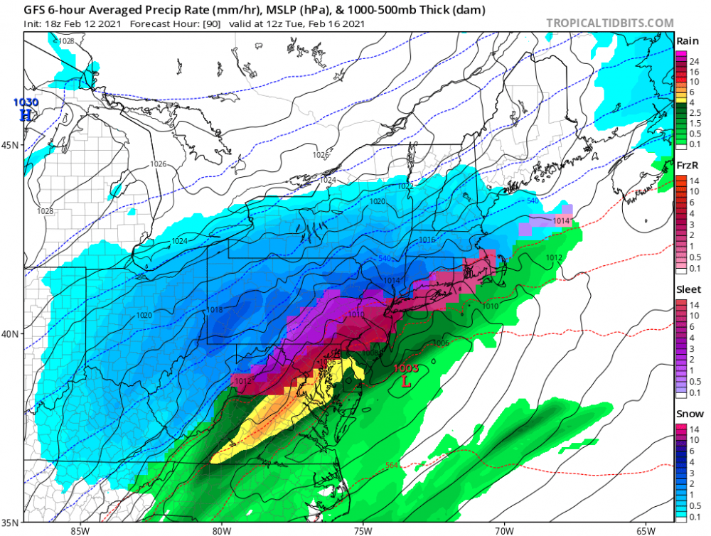
-
Western Pa / Pittsburgh area Winter Discussion ❄️☃️
dj3 replied to north pgh's topic in Upstate New York/Pennsylvania
It’s about to hit it us with the second wave also. This could be a run to save LOL. ETA: probably still going to be messy on the second one but trending in the right direction -
Western Pa / Pittsburgh area Winter Discussion ❄️☃️
dj3 replied to north pgh's topic in Upstate New York/Pennsylvania
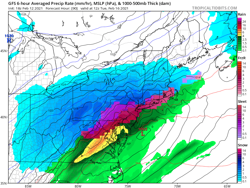
0z gfs run is probably the peak for mon/Tuesday. Overrunning and a perfectly squeezed primary into a coastal transfer. -
Western Pa / Pittsburgh area Winter Discussion ❄️☃️
dj3 replied to north pgh's topic in Upstate New York/Pennsylvania
Seasonal trend has been to de-amplify things so I think we are in a pretty good spot for Mon-Tues for mainly snow. Even the late week storm next week I would think we are still in the game, although high pressure looks like its departing so maybe more cutter risk with that one. Moisture doesn't look to be a problem for the next 10 days at least. -
Western Pa / Pittsburgh area Winter Discussion ❄️☃️
dj3 replied to north pgh's topic in Upstate New York/Pennsylvania
Couldn't agree more, most active tracking period in a while. I don't expect to get a flush hit from any particular wave but nice to see some appetizers for bigger potential next week. -
Western Pa / Pittsburgh area Winter Discussion ❄️☃️
dj3 replied to north pgh's topic in Upstate New York/Pennsylvania
With the Euro never really biting on the big storm the GFS had been showing for sunday, I think you could be right.