Normandy Ho
-
Posts
3,180 -
Joined
-
Last visited
Content Type
Profiles
Blogs
Forums
American Weather
Media Demo
Store
Gallery
Everything posted by Normandy Ho
-
yep starting to crank just a little bit. family down near lake jackson says its getting windy.
-
http://tropic.ssec.wisc.edu/real-time/dlmmain.php?&basin=atlantic&sat=wg8&prod=dlm3&zoom=&time= The stronger this storm gets the more its going to be pushed NNE. the slowdown and due north center fix is interesting and might indicate this might be happening. Seeing zero gains longitudinally now and still due south of houston. gotta keep watching. Additionally, looks like we got a big meso on the south side again. lets see what happens as it rotates around.
-
Also NNE if previous fix. Have to watch closely over the next few hours. This might be feeling the trough more than expected (which is great for Houston if true)
-
That and an east slide. One thing I’m watching…….the storm is due south of Houston and intensifying. The trough is digging and will start to influence beryl. I’m not seeing this getting far enough west to matagorda from its current position
-
@40/70 Benchmark I think you hit your 95 mph call. there are signs that Beryl is starting to deepen. Velocity on radar is increasing, big blow up / meso on the south side is rotating around, and potential new hot towers on the north side are firing. I do think its too late for a major but 95 mph might still be possible.
-
Let’s see what this big meso on the south side can do. Thankfully thus far beryl has behaved
-
Morning trends are not the friend of houston. It would appear the turn north has already started and there won’t be much more westward progress. Looks very likely to come ashore east of Matagorda bay, somewhere west of Galveston bay. This puts all of metro Houston in the Eastern eyewall. regarding intensity. It’s got 24 hours till landfall, incredible conditions for rapid intensification (especially aloft). It’s currently sitting at 988 or so. Given the time over water and favorable conditions, a landfall in the 960s is not out of the questions. Given the broad core, not sure the winds that translates too (maybe 100-115 mph). Will begin updating family and friends and checking in them in Houston.
-
So you quoted me to simply repeat what I said lol. Cool. It was more eloquent at least.
-
^i feel you. Now is the time to banter tho as beryl is in the middle of the ocean. Once we get closer to game time / landfall the banter will slow
-
I think you are analyzing this the wrong way. It’s not the beryl is a sentient being that can overcome shear at will. Beryl has a certain relationship with shear that, frankly, models and Mets missed (and that’s fine, happens). What that relationship is I don’t know. But during this storms life it’s always been in a high shear environment and thrived (and still is btw). Each storm is different, and this one does well with shear. Others don’t. To your point though, can’t use past success to predict future success for beryl. What happened in the carribean is in the past
-
I think because this storm has been so unpredictable thus far in the face of adverse conditions, I get where Ryan Maue and Eric Webb are coming from. It’s not the same condition as Harvey, but Harvey also wasn’t a north moving storm with a HELLISH jet stream to the north. There are also very high CAPE values in the new gulf as well. Both could potentially really help this storm fire deep convection and ventilate it well. I honestly have no idea how intense it will be. I think the cap is a major but that’s also dependent on track (does it move further up the coast and get more time over water?). Just gotta watch and see, I don’t envy the NHC with this storm (and they have done great so far)
-
This bruh. Legit don’t understand at all what the fuck is going on with this stupid storm
-
Haircut time!
-
Excellent point @gymengineer. This is why I’m very nervous for the upper Texas coast. At this point I’m hoping for an east trend to TX/LA but that seems wishful at this point
-
As a native houstonian who now lives in Cali…..I’m very very nervous. If you want a hurricane in Houston, these are the model plots you want to see (because they always adjust north when a western gulf storm recurving). Add that to the fact that the fucker crossed Cozumel when zero models showed this……ya I’m nervous.
-
I say it tongue in cheek since they are the OTHER board. That being said I find him too conservative as a forecaster and he doesn’t make adjustments to his thinking when things aren’t going as planned (both intensity and track). He’s def knowledgeable tho I just use others guidance more than his.
-
Come on man don’t post S2K bullshit on here. The mets AND amateurs here are far more knowledgeable than him
-
I can’t anymore with this storm lol. That can’t be a pinhole

-
2024 Atlantic Hurricane Season
Normandy Ho replied to Stormchaserchuck1's topic in Tropical Headquarters
What’s funny is beryl isn’t even done. This season could have four or five beryls potentially (long track majors) -
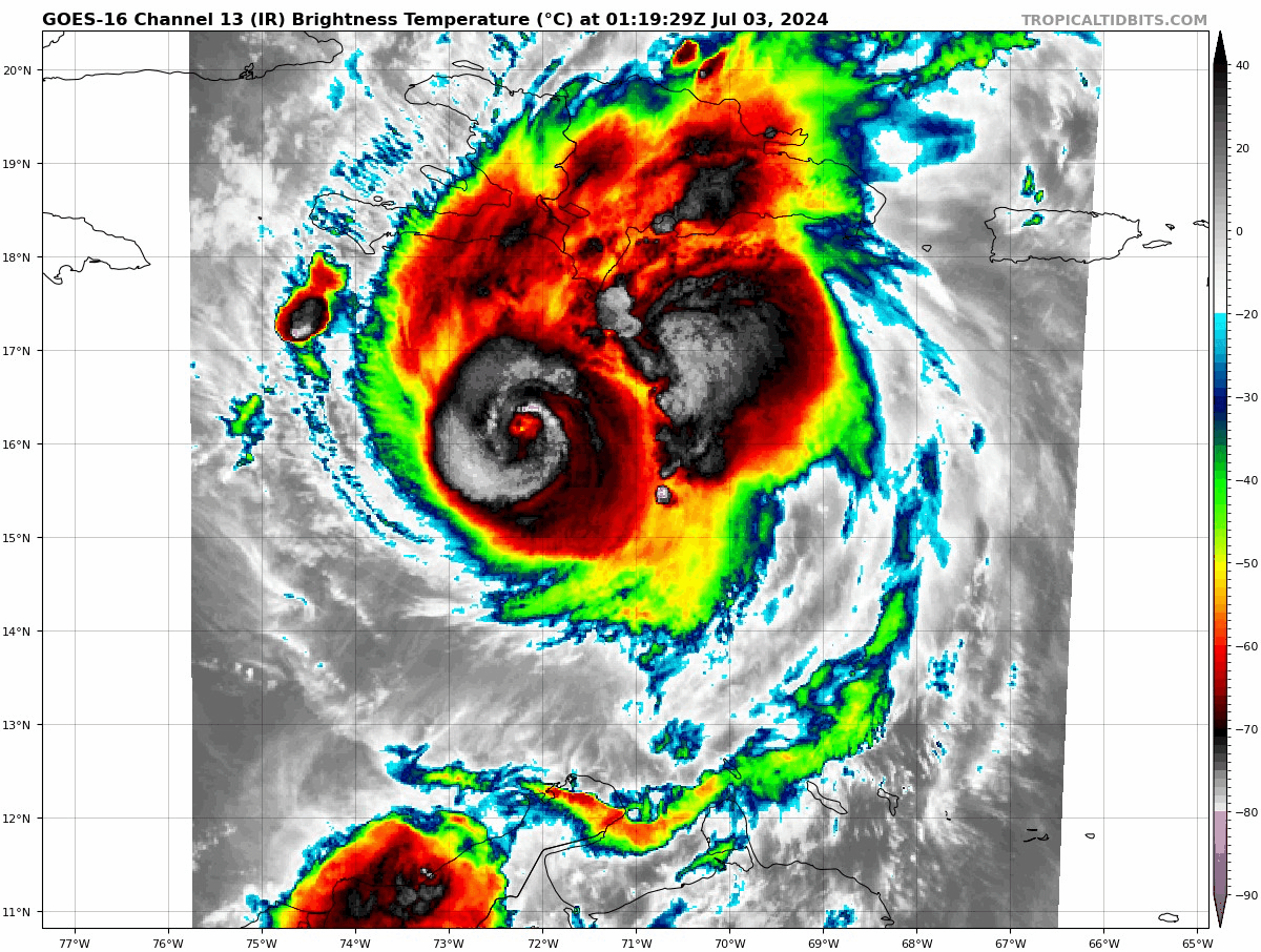
Yep was gonna say those mountains definitely did something because the core looks savage right now on radar and IR. Started happening right as it approached the island
-
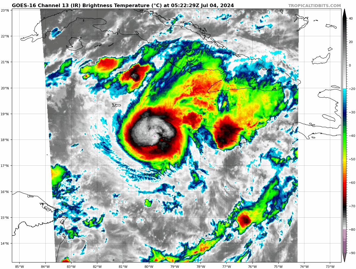
People who are saying this is weakening must not understand what they are looking at. I get that shear was suppose to upend this but we have to look at what’s happening in real time. It ain’t weakening. Now admittedly it ain’t pretty, has a very odd structure but it’s obviously still very intense
-
Usually when you see this signature, ten hours later you have a 180 mph monster. Wild wild storm

-
I’ve seen enough. The TUTT isn’t shredding this thing. The major shear axis has already been pushed to over and just west of Jamaica. All the TUTT did apparently was piss it off. Best we can hope for is steady state from now and a miss south of jamaica
-
This is perfect timing for recon. Monster convective burst commencing
-
I digress as this is a beryl discussion and perhaps a separate thread can be made for building code construction, but cost of living in California isn’t actually related to our building codes being stringent. It does impact cost of construction, but land values are high because of the weather in Cali (and proximity to all types of natural forms entertainment like beach, snow, mountains, etc.