

Normandy
-
Posts
810 -
Joined
-
Last visited
Content Type
Profiles
Blogs
Forums
American Weather
Media Demo
Store
Gallery
Everything posted by Normandy
-
The most certainly will get upgraded during the next NHC pakcage
-
This thing is crawling to the coast at this point. Gonna need to make some progress inland since models are forecasting a stall and turn east
-
Watching closely for any convective burst occurring on the western flank of the circulation. Radar suggests that the storm while deepening is still limited with respect to western Inflow
-
This would be nothing new to Houston. These 1 and 100 year floods are no longer 1 and 100 year anymore. This region of the country is used to flood events like this. I’m more concerned about this over performing from a wind standpoint. It’s generating a lot of vigorous convection which is usually a sign that over performing in intensity is a possibility
-
2021 Atlantic Hurricane season
Normandy replied to StormchaserChuck!'s topic in Tropical Headquarters
If your measurement of active is cat five hurricanes making landfall then sure I guess you are right. Problem is that’s not how active seasons or active periods are measured. -
Im imagining that what we see now is kind of the upper limit for intensity with Larry. A cane this large needs serious juice to push CAT 4 or greater levels and I am not sure the waters It will traverse can support that. Would be interested to hear pro met thoughts on this. Never the less beautiful storm
-
Those who are a disappointed with damage produced need to give more props to human engineering and understand that Cat 4/5 hurricanes are not nuclear weapons. Many structures will survive these storms (even wood framed buildings). If wind damage in Mexico beach was worse, it is very likely building code related as Michael was not much more intense than Ida. neighborhoods being flattened are limited to only the severest of hurricanes (Dorian, Andrew, Labor Day, etc). Winds have to be greater than 170 mph before that can occur. Also got to give a shout out to those that designed and engineered the levees. They were tested and they passed
-
No matter the situation that New Orleans is currently in, you simply cannot argue that it wouldn’t be worse had the storm moved 10 miles to the right. Yes they got hit hard, but they could have gotten hit harder. What’s wrong with stating this?
-
Let’s wait until the dust settles before answering that one
-
If verified it would top hurricane Andrew’s 142 mph. It should be noted though that this measurement occurred before the worst of Andrew’s eyewall passed over Fowey rocks. Nevertheless epic storm Ida was.
-
Unfortunately for New Orleans Ida is crawling right now. They are seeing a very extended period of hurricane force winds
-
They are absolutely out of the woods with respect to severe winds. Flooding and surge that’s another story but you all already know this so I’m not sure why quoting me and stating New Orleans is not out of the woods yet is necessary
-
Easily a top five hurricane landfall in the north gulf coast. Thankfully a far west track and slow movement spared New Orleans the worst but others certainly took it on the chin
-
There have been several videos and wind reports showing category 3 conditions. You gotta look a bit harder. The storms resilience over land is quite something
-
oh man when people wake up tomorrow…..yikes. The amount of strong mesovorts on IR is quite stunning
-
12 mb drop between passes?!?
-
Considering how this thing looks on radar and satellite I think they find big winds in the NE quad
-
Agree on ETA last year that was truly hilarious shit. Looking forward to maybe some of that tonight
-
The absolute worst case is a westward approach where the north eyewall passes over Lake P. The approach ida is taking is the second worst case. Strong NE winds will back water up into the lake, and strong south winds bring surge from the south.
-
New Orleans is in trouble from a surge perspective no matter where the storm hits because of the angle of approach and general proximity of the core. The only question is do they get the Cat 3 or greater winds.
-
Storm is about to go to work now. Wouldn’t be shocked if it was a major by noon
-
That’s a terrible rant and take. “Storms always will happen so we shouldn’t try and be better with our carbon footprint”. It should have been deleted and should be removed again
-
Stick to the banter thread and you’ll be safe
-
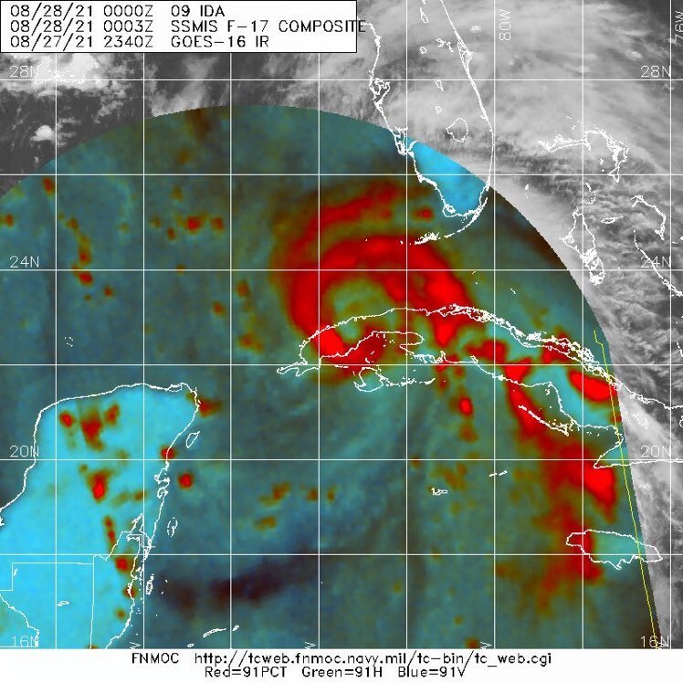
This microwave image is suggestive of a much larger core forming. Will be interested to see what recon finds
-
agreed nobody should mention that glorified Nor’easter when we speak of real cyclones


