

Hoosier
-
Posts
47,183 -
Joined
Content Type
Profiles
Blogs
Forums
American Weather
Media Demo
Store
Gallery
Posts posted by Hoosier
-
-
1 hour ago, Chicago Storm said:
Easily the best looking LE on the western half of the lake this winter.
.Not totally certain, but the eastward progress may be slowing or about to slow. Snowing decently here.
-
Band is really cranking now but heaviest is offshore. Some 35 dbz showing up.
-
53 minutes ago, Chicago Storm said:
Toss.
Main convergence axis is passing downtown right now, and has been steadily shifting east. It's already fully offshore from NE Cook Co up through SE WI.
Will be curious to see how quickly it shifts through northwest IN. Winds are currently N to NNE on the eastern end of the lake.
-
11 minutes ago, A-L-E-K said:
Lake enhaced defo is good
HRRR is trying to put out a narrow weenie band of 3-5" from downtown southward through the IL/IN state line.
-
19 minutes ago, SchaumburgStormer said:
South… weaker….
Fwiw, there are some ensembles that are farther south (not that that's too surprising) and get Chicago in the game. But certainly not a favored outcome at this point.
-
Just eyeballing out the window... have a light coating of something... either snow or sleet.
-
13 minutes ago, Chambana said:
MSP special. Spring winning the battle
At least you should get into some real deal warmth there (60s plus). Here it will probably be something stupid like being stuck in the 40s or spiking higher at like 3 am when nobody is outside anyway.

-
 1
1
-
-
Let me just get this out of the way from the top. I fully expect this to be a fail storm imby given the current depiction and the way the season has gone so far really leaves no reason to be personally optimistic.
With that being said, we currently have pretty remarkable model/ensemble agreement on a potential big (or biggish) ticket item affecting the sub next week. It looks to have a lot of moisture and a tremendous thermal gradient. Potential exists for pretty significant snow and ice accumulations, certainly favoring north of I-80 (possibly well north).
-
3
-
-
1 minute ago, Weather Mike said:
Very nice
Here in Chicago not much but cold rain
I wonder what temps are like in the city right now. Been poking around my local/neighborhood obs and most have dipped to freezing. GYY is also down to 32.
-
Yay I got an advisory.
-
1
-
 1
1
-
-
13 minutes ago, Chicago Storm said:
Got in to ORD about a half hour ago to find not only has PL dominated precip type, but the RA being reported was actually FZRA for the most part.
There's a glaze of ice on colder/elevated surfaces, and several tenths of PL accumulation.
During the morning/early afternoon before I got in, precip type has been a mix of SN/PL/FZRA/RA. Since getting in a bit ago, things have transitioned from PL/FZRA to PL to GS and now to -SN.
Interesting re: freezing rain, considering that temps at ORD were 33-34 almost the entire time.
I can think of a couple possible explanations. Dews have remained below freezing. The warm layer aloft around ORD also isn't that warm and there's a good cold layer underneath, as evidenced by all the sleet there. The raindrop temps are probably pretty cold as they are hitting the surface, and colder objects/elevated are just cold enough despite 2m air temps being above freezing.
-
Shaping up to get icy later. Have some puddles around, and there will be a lag between temps dropping below freezing and precip changing over to snow. Plus will lose any solar insolation contribution later.
-
Good general model agreement on a winter storm with significant snow and ice potential next week.
-
1
-
-
Looks like a good chance that areas south of I-80 will get skunked in the upcoming regime. Better chances the farther north you go.
-
1
-
-
Just now, beavis1729 said:

Chicago winter at its finest.
-
Seems like guidance is delaying the changeover to snow around here. Now looks like it won't be before 00z and possibly as late as 02z-03z. Should transition to light sleet/zr later before flipping to snow.
-
Just now, mimillman said:
Heavy rain
Yeah just had some of that here.
-
More recent short range guidance has gotten more bullish on hanging up the lake effect band on the Illinois side for a while late tonight/early tomorrow.
-
Whether this actually happens or not is debatable, but there's a multi-model signal on the lake band stalling out somewhere around here for several hours tomorrow night. Even if that were to occur, it's unclear just how robust it will be. The parameters are decent, but not spectacular, and some models do establish some low level convergence with NNW winds on the western end and NNE winds on the eastern end. All I'd say with confidence is that the HRRR is overdone, but the question is how much to cut it by. 50%, 75%, some other number, etc.
-
23 minutes ago, buckeye said:
Appropriately shaded sh*t brown…only thing missing is the squatting big dog
All-time legendary map
-
1
-
-
21z RAP is trying to do its best impersonation of the HRRR in regards to lake effect.
-
4 minutes ago, michsnowfreak said:
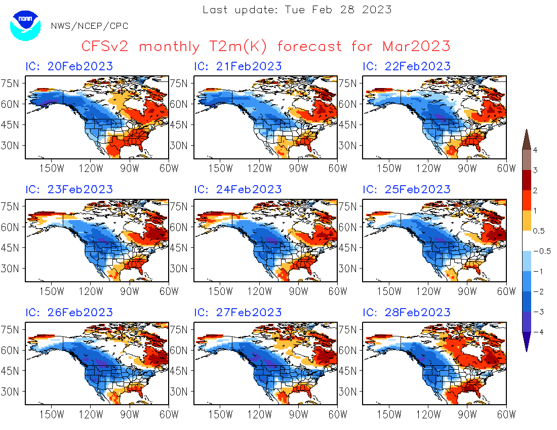
Even if it turns out to be a mild March, it's not gonna be those insane departures of 2012. Enjoy the flip flopping cfs.

A prediction that would be right like 99% of the time.
-
The palms weep
-
2
-
5
-
-
36 minutes ago, hardypalmguy said:
mich
snowpalmfreak is going to love Morch 2023.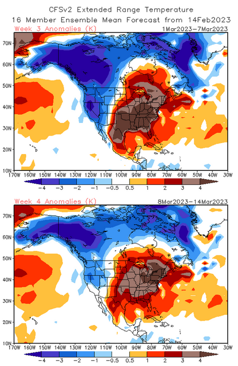
Trending good

-
1
-


2/16/23 Winter Storm
in Lakes/Ohio Valley
Posted
Band has definitely come to a screeching halt. Wouldn't be shocked to see a narrow axis overperform in Lake county Indiana.