

Hoosier
-
Posts
47,183 -
Joined
Content Type
Profiles
Blogs
Forums
American Weather
Media Demo
Store
Gallery
Posts posted by Hoosier
-
-
6 minutes ago, A-L-E-K said:
Bust
LOT may need a flood headline for Cook.

-
Definitely keeping an eye on this one. My mom is currently driving through central IL heading for SE Missouri.
-
Looking at radar trends, the more southern placement of the heaviest precip axis does not seem particularly likely to verify. Imo. GFS/Canadian (and now 12z Euro) may end up being closer to reality in terms of placement.
-
32/30 with moderate freezing rain at Waukegan. Mentioned it yesterday but that has been one of my prime areas of interest in the LOT cwa. You know areas farther inland in far northern IL have a better shot to hold at or below freezing throughout, but can those areas closer to the lake hold on to freezing temps as the afternoon wears on and how much icing will there be?
-
7 minutes ago, HillsdaleMIWeather said:
IWX In their afternoon update thinks there’s a chance Hillsdale could stay all freezing rain, not good lol
Already power outages in Hillsdale county. This thing is going to be a disaster in MI.
-
-
Oh Morch, where art thou going?
-
 3
3
-
 3
3
-
-
Still have some spread in placement of heaviest precip. In general, the Euro(06z run)/NAM/short range models are farther south than the GFS and Canadian models.
-
Doubt there are any road issues, but Valparaiso was at freezing and reporting freezing rain or unknown precip for like 4 hours.
-
1 hour ago, sbnwx85 said:
Hanging on to 32 degrees. Moderate rain coming down. The ice is having a harder time accumulating but there’s a little more than a couple hours ago. Still nothing on the ground so roads, outside of bridges and overpasses, shouldn’t be bad.
Had a brief period earlier with temps at 32. Now above freezing.
-
Looking at obs from central IL, temps are generally dropping a couple degrees in the hour after precip onset.
-
If we had the system early next week later in the season... ho-ly hell.
-
1
-
-
That system early next week isn't much to look at from a wintry perspective, but I'm still a bit interested in seeing if pans out. Don't get a surface low of that progged strength that far south in the sub very often at all.
-
7 minutes ago, Harry said:
I am gonna have a backyard full of downed trees and power lines . Ugh
Pics or it didn't happen.

Stay safe
-
When you look at current dewpoints, it's almost hard to believe that we will have dews in the low 30s in parts of northern IL/IN in about 7-10 hours... as these areas will be north of the warm front.
But aloft, we have massive moisture transport from the southwest. You can run a loop of 850 mb dewpoints to get a sense of that. So I expect those types of dews (or at least something close to that) to pan out.
-
56 minutes ago, Natester said:
Well, it's already 31F here based on the observations from several PWS in the Cedar Rapids area. The HRRR and the NAM had Cedar Rapids in the upper 20s at this time.
EDIT: Cedar Rapids Airport reporting a temp of 31F at 10 PM.
Clouds helping to keep temps from dropping.
You also want to look at dews/wet bulb temps. Still have a decent temp/dewpoint spread at CID with dews in the lower 20s.
-
-
I've gotten as skeptical as anybody when it comes to this winter, but honestly just kind of have a gut feeling that I haven't seen my biggest snow yet this season (of course the bar is pretty low)
-
38 minutes ago, michsnowfreak said:
Let's see if we get a big March snowstorm. All guidance looking cold mid March.
Indications are March won't be tame. Just a question of details and who gets what.
-
Alek nightmare scenario

-
1
-
-
Not the strongest surface high that we've seen, but there's a nice cold/dry air reservoir in Michigan/Wisconsin to pull from. Dewpoints are in the teens or lower in basically the entirety of those states.
-
4 minutes ago, ILSNOW said:
KLOT went with Winter Weather Advisory
ILZ003>006-220500-
/O.NEW.KLOT.WW.Y.0005.230222T1200Z-230223T1200Z/
Winnebago-Boone-McHenry-Lake IL-
Including the cities of Rockford, Belvidere, Crystal Lake,
Algonquin, McHenry, Woodstock, Waukegan, Buffalo Grove,
Mundelein, and Gurnee
300 PM CST Tue Feb 21 2023

...WINTER WEATHER ADVISORY IN EFFECT FROM 6 AM WEDNESDAY TO 6 AM
CST THURSDAY...

* WHAT...Freezing rain and sleet expected. Total ice accumulations
  of two to three tenths of an inch with locally higher possible
  near the state line, while total sleet accumulations up to one
  half inch. Winds gusting as high as 35 mph.

* WHERE...Winnebago, Boone, McHenry and Lake IL Counties.
The middle to high end range of their forecast ice amounts would be warning criteria. Will be interesting to see the reasoning in the afd.
-
7 minutes ago, ILSNOW said:
18z NAM FRAM 9with 2m temps in Northern Chicagoland hovering around 32 those ice #'s below are hard to believe)

My understanding of FRAM is that it's based on 3 main things -- wetbulb temps, wind speeds and precip rates. I'm still unclear on whether it accounts for warm layer temp. The wind is pretty favorable for enhanced accretion, but the precip rates and wetbulb temps aren't (too heavy at times and too borderline, respectively). FRAM will be better than using the freezing rain qpf maps in this case, but it would still make sense to go under that imo.
-
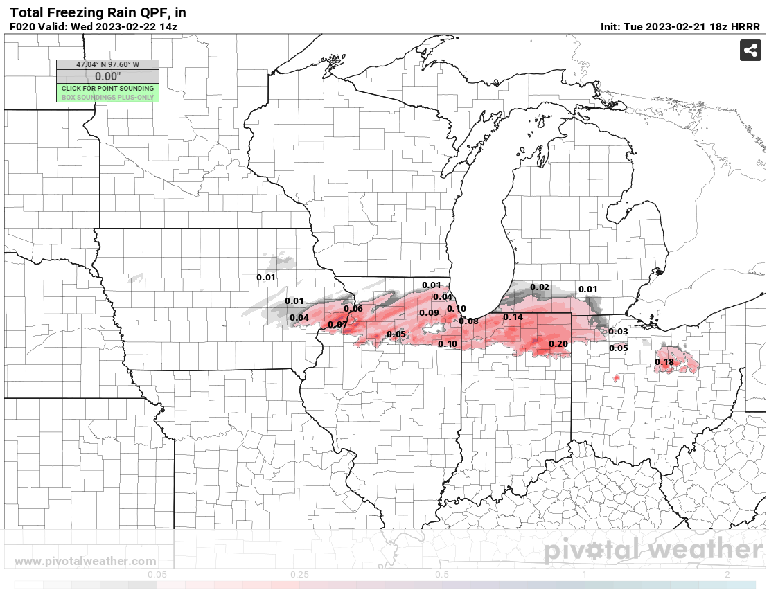
2 minutes ago, sbnwx85 said:
Look at what the HRRR puts down before temps go above freezing for my area.
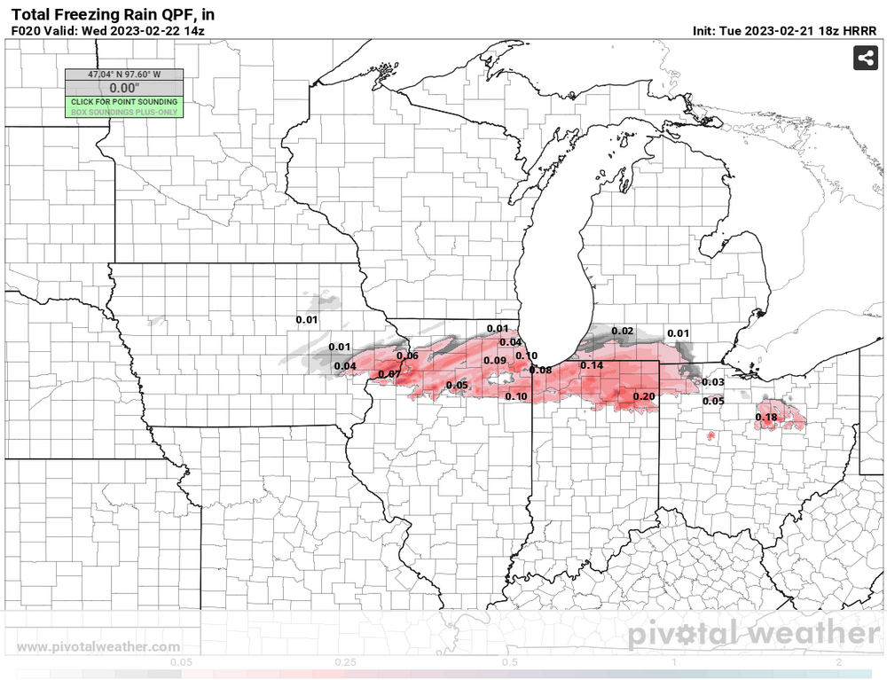
The 18z NAM is trending this way as well, though still has the placement a bit farther north.

Winter 2022/23 Medium/Long Range Discussion
in Lakes/Ohio Valley
Posted
Incredible depiction on the 12z Euro. 974 mb low in Arkansas (yes Arkansas) moving northeast, though doesn't strengthen much further. 70 kts in the CCB as it moves from the MS Valley into the Ohio Valley.