

Hoosier
-
Posts
47,183 -
Joined
Content Type
Profiles
Blogs
Forums
American Weather
Media Demo
Store
Gallery
Posts posted by Hoosier
-
-
This Thursday wind setup is looking good. Solid advisory criteria with a shot to go higher in some spots. Mixing could be excellent.
-
1 hour ago, cyclone77 said:
Looking like a 34 degree rainer for the QCA. Wish we could fast forward to May.

March will be rocking.
Probably in MSP again.
-
 2
2
-
 1
1
-
-
3 hours ago, frostfern said:
It's kind of a complicated situation with the lead low having most of the moisture. On the GFS there's a definite break between the initial surge of overrunning precip and the main low. I don't know if that will help much though. The warm sector looks mostly dry, but there could be one of those narrow lines of convective showers right by the cold/occluded front that pulls some strong gusts down to the surface.
Also have some uncertainty on the exact track of the second low. The first wave is pretty well agreed upon to go through central IL/IN and into Ohio, staying south of Michigan. ECMWF and Canadian aren't as far north as the GFS is with the trailing low, and the best winds with that should occur near/south of its track.
-
14 minutes ago, cyclone77 said:
You can tell Hoosier's excited for this system lol

Tryin for 50k by the end of this year.
-
The GFS solution would be pretty wild, especially in parts of MI. Lots of ice, which would be followed by quickly melting/falling ice courtesy of very strong winds as the trailing surface low of decent depth passes nw.
-
GRR weenied out a touch in their afternoon afd. Specifically about the Canadian and its sleet. Good points though.
-
 1
1
-
-
18 minutes ago, RCNYILWX said:
I'd recommend grabbing the winter sounding from COD (just have to select winter and generate new sounding) or go to Pivotal Weather which automatically will give a winter sounding.
On the bottom right of the winter soundings, you'll see layer energy information, which is the Bourgoin method to determine precipitation types. It's analogous to CAPE and DCAPE, positive energy aloft and negative energy low level. The precip. type tab in BUFKIT uses the Bourgoin method.
Any positive energy of 25+ J/kg represents full melting, while sleet probabilities increase at -75 J/kg and below. Even with high positive energies (near or above 100 J/kg), negative energies of -100 J/kg or lower tend to allow for sleet to at least mix in and the higher magnitude negative energies can overcome high positive energies to result in primarily sleet. The preferred profile to use is the wet bulb vs. solely temperature based profile.
Two examples of this from the 12z ECMWF below, first from interior far northeast IL and the other from near the state line on WI side of the border.

Sent from my SM-G998U using Tapatalk
Thanks! Kinda embarrassed to say that I didn't know COD had that winter selection lol. I was basically eyeballing the positive/negative energies on the soundings, but it's nice to have numbers.
-
1
-
-
Here are two GFS forecast soundings valid at the same time. One is from Waukegan and one is from Rockford.
First up, Waukegan...
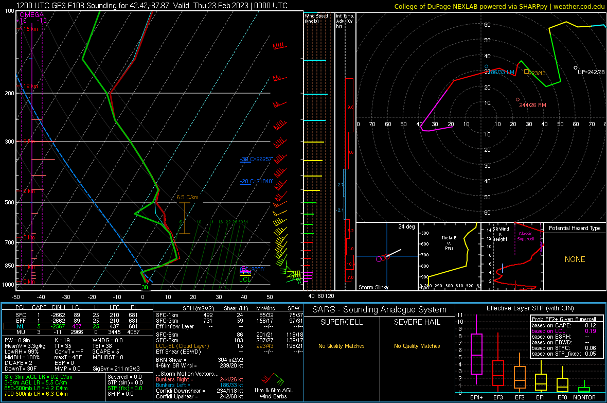
Here we see a deep warm layer above 0C from just under 850 mb all the way up to 700 mb. There is a respectable cold layer colder than 0C underneath this, but its depth and magnitude is not quite like what the warm layer is. There is also a bit of mid-level dry air/lack of saturation. These factors point toward this being more of a freezing rain sounding instead of sleet. If you notice toward the bottom of the graph, the solid red line is essentially touching the light blue dashed line, which represents sfc temps right around freezing.
Now going over to Rockford...
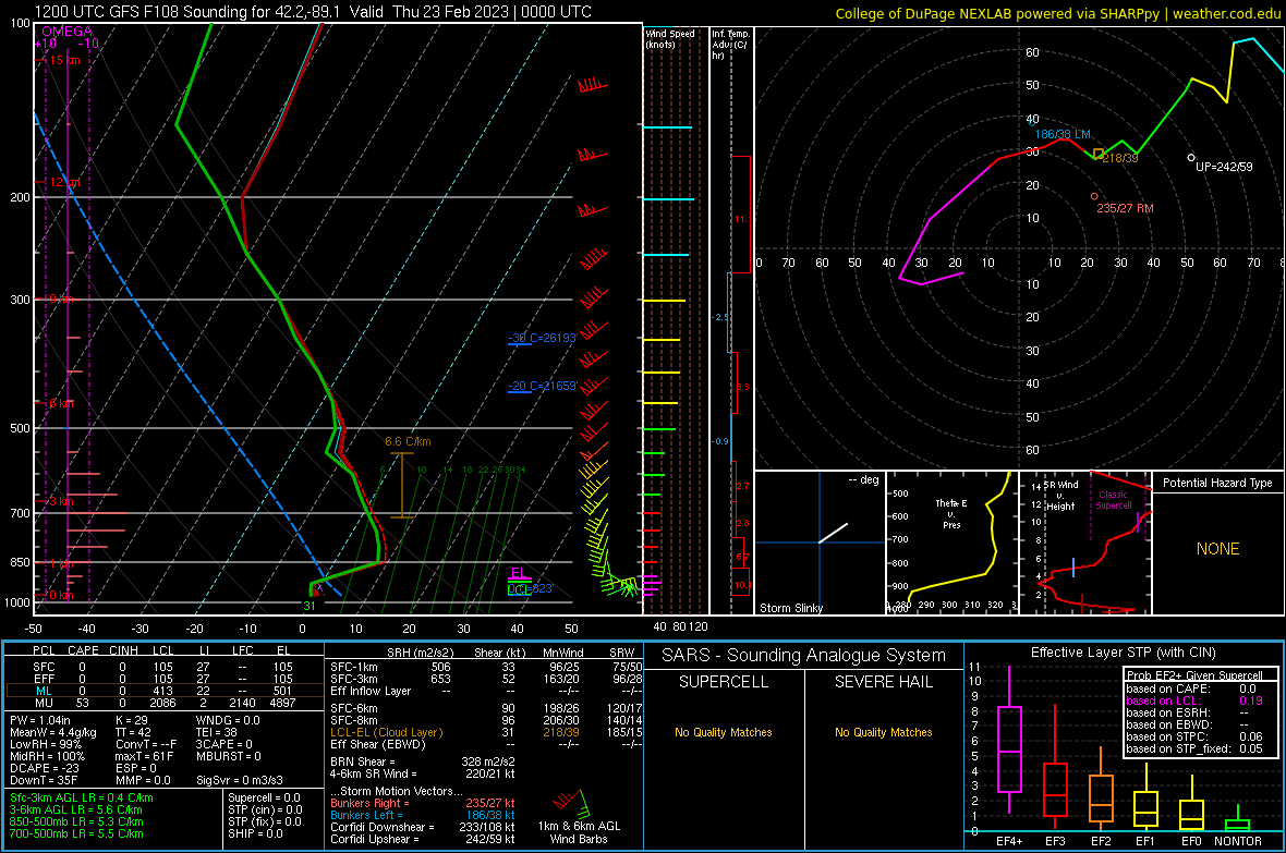
Here we see a deeper warm layer aloft that goes from about 900 mb to 700 mb, and it's also warmer. There's also less of a cold layer underneath than there is at Waukegan at that same time. Interestingly, despite this larger/warmer warm layer and less pronounced cold layer, you see similar sfc temps as Waukegan, which I have to believe is the model trying to account for marine influence vs no marine influence. Even with sfc temps around freezing at Rockford on that forecast sounding, I would argue that it would be difficult to keep sustaining freezing rain given the absolutely massive warm layer aloft and marginal sfc temps, assuming this depiction is correct of course.
All in all, will be interesting to see how this turns out. You'd put the icing threat north of Chicago at this point... especially the core of Chicago. But I don't think it's as simple as to say that there won't be icing near the western shores of Lake Michigan. It will likely depend on how far north you are.
-
44 minutes ago, sbnwx85 said:
I’d imagine it would be tough to get much ice along the Illinois/Wisconsin side of the lakeshore with water temps in the mid-30’s and an east wind. Otherwise, it looks like a nasty storm where ever that corridor sets up.
I think it will depend on the finer scale details of the near-sfc cold layer. If 925 mb temps are like -3C to -4C, then that should be able to offset a marine influence enough to keep temps below freezing. Of course if the low level cold layer is cold/deep enough, then it would tilt things more toward sleet, with the better chance of sleet currently being with northward extent into WI.
-
Of course there will be ice in this setup. It's about as certain as death and taxes. The main questions are magnitude and corridor (though the model agreement on corridor is almost freaky that you wonder if it can hold all the way until go time).
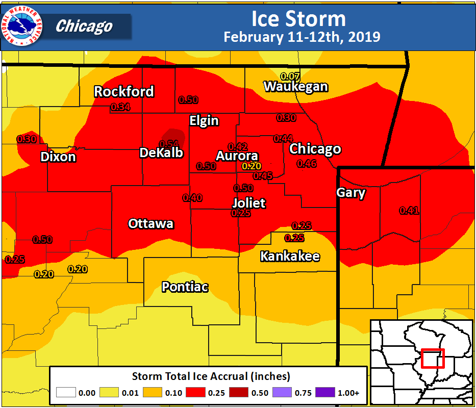
Let's take a trip down memory lane. Toward the middle of March 1991, there was a really bad ice storm that affected a good chunk of northern Indiana and down toward the Lafayette-Kokomo area. Temps in the days leading up were in the 40s and 50s. I don't how the roads were, but I know what the trees looked like because I've seen the pics. There was a lot of tree damage and power outages, and it's safe to say it was one of the worst ice storms to ever impact that part of Indiana.
Tree and elevated object temperatures follow along more closely with the air temp than something like a paved surface. Antecedent conditions aren't really going to matter when it comes to getting ice on these types of objects. We have seen the opposite of this coming out of a deep cold spell where air temps can be in the mid-upper 30s and the ground will still be icing for a while but the trees aren't.
-
2
-
 1
1
-
-
0 in Fargo and 70s in St. Louis

-
Was perusing some forecast soundings in the freezing rain zone and holy cow at the warm layer aloft. Very thick and it gets pretty warm in parts of the target area.
-
20 minutes ago, Baum said:
Call me crazy, but I think Chicago can reel this one in......or I'll head to Milwaukee.
Seems like a tall order from a snow perspective. Something like this is more of a possibility (not saying it's likely though)
-
1 hour ago, OrdIowPitMsp said:
Hard pressed to find model/ensemble solutions that miss Minnesota. Even the ones that have a track through the I-70 corridor of IL/IN have an expansive snow shield throughout Minnesota. That solution obviously wouldn't be as impactful there, but it wouldn't be a miss either.
-
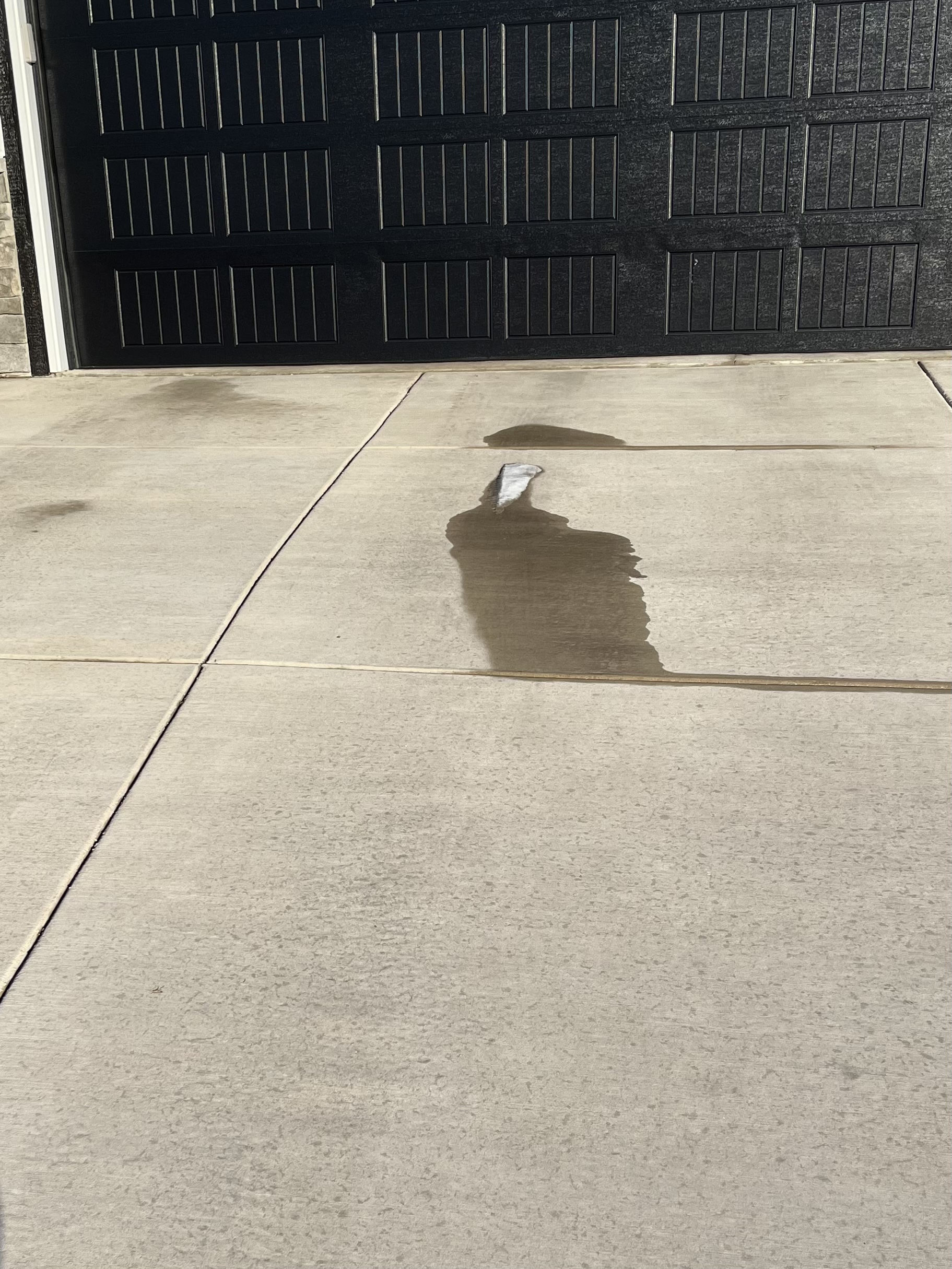
9 minutes ago, madwx said:
Didn’t stand a chance
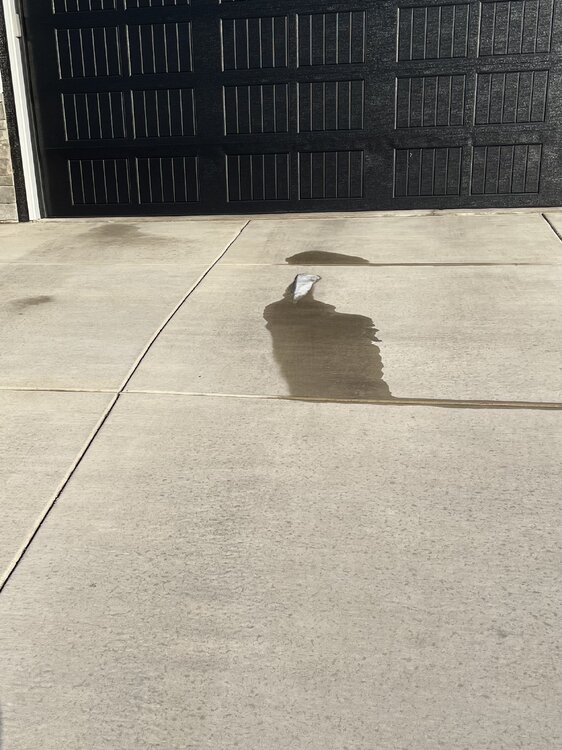
My driveway looks just like that. No snow and almost completely dry. Had a couple inches on it this morning and temps were in the 20s all day.
-
Noticed that some offices have already put freezing rain in the forecast. Rarely see that at 5+ days out (usually it's straight rain or snow forecast)
-
12 minutes ago, RCNYILWX said:
A zone of significant icing and sleet to its north certainly plausible in this setup, and severe weather in the warm sector. The sharp baroclinic zone and juiced air mass would still be in play with a weaker system, so given the 1035-1040 mb high pressure sandwiched to the north and northeast, that would bring the freezing rain and sleet zones farther south.
As it stands, the 12z ECMWF verbatim showing ice storm criteria ice amounts (including with FRAM estimate) and 1-2" of sleet north of I-88 and into southern Wisconsin even with a fairly deep surface low is a red flag for what would happen with a slightly weaker and farther south low pressure track.
A decent number of 06z EPS members tracked through downstate IL/IN.
Also appears like we could have multiple surface lows.
-
9 minutes ago, ILSNOW said:
12z Euro (way to early) agrees with you ice comment

A dire emergency for palm lovers if there's a modest shift.
-
Don't see a 984 mb low in southern Nevada very often

-
1
-
-
5 minutes ago, roardog said:
This one could be quite an ice storm somewhere since it will have a ton of moisture and respectable shallow cold to the north of the front.
It should pack a punch wherever it ends up. Barring a complete collapse/change in evolution, this should be a fairly breezy storm. You don't need an inch of ice to cause a lot of impacts when you throw in the wind.
-
1
-
-
8 hours ago, TheRegionRat said:
Snowing at decent clip here. It looks like there's a decent amount of snow on the ground.
What did you get? I measured 3.7" this morning, which is the biggest snow of the season lol. Can tell that the sun is doing work though even with temps in the mid 20s, so I may be seeing the grass again before this day is done.
-
A fair number of GEFS members are cold enough for ice in Chicago. Not many showing snow.
Even the op runs of multiple models put far northern IL in an icing threat, so wouldn't take much shifting to get that into more of the metro.
-
Lake band ticking back west now. Snowing here again.
-
14 minutes ago, Chicago Storm said:
Added another 1.0" at ORD from 0-6z, for a final storm total of 2.0".
Brings the total to date to 16.2"
February 21-23 Major Winter Storm
in Lakes/Ohio Valley
Posted
Was surprised to see the GFS even trying to paint a little ice here. Seems like an outlier at this point.