

Hoosier
-
Posts
47,183 -
Joined
Content Type
Profiles
Blogs
Forums
American Weather
Media Demo
Store
Gallery
Posts posted by Hoosier
-
-
Seeing continued ticks south on the HRRR runs from late this morning. So probably expect 18z run to come in south of the 12z run.
-
Meanwhile
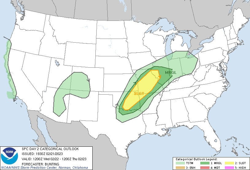
Day 2 Convective Outlook
   NWS Storm Prediction Center Norman OK
   1129 AM CST Tue Feb 21 2023

   Valid 221200Z - 231200Z

   ...THERE IS A SLIGHT RISK OF SEVERE THUNDERSTORMS FROM CENTRAL AND
   EASTERN OKLAHOMA NORTHEAST INTO WEST-CENTRAL ILLINOIS...

   ...SUMMARY...
   Severe thunderstorms are possible from Wednesday morning through
   afternoon from parts of Oklahoma into western Arkansas, across
   Missouri and western Illinois. Damaging winds appear most likely.

   ...Synopsis...
   Within a large-scale mid/upper-level trough, a pronounced shortwave
   trough will lift rapidly northeast from the southern Plains towards
   the Great Lakes.  Intense low/mid-level wind fields will accompany
   this shortwave trough as it accelerates northeast and generally
   weakens while moving into a more confluent mid-level flow regime.
   Farther west, a strong upper-level speed max will drop south along
   the west coast and contribute to the development of a closed upper
   low near the CA coast.  Surface low pressure will develop along a
   front over eastern KS and move towards northern IL late Wednesday.

   ...OK northeast into MO/IL/IN and northwest AR...
   Strong/severe thunderstorms may be ongoing across central/eastern OK
   at 12z Wednesday in the vicinity of the dryline/cold front. The
   presence of surface dew points in the upper 50s/lower 60s will
   contribute to modest instability ranging from 250 to 750 J/kg across
   the warm sector during the day, and storms are expected to move
   rapidly northeast during the morning and afternoon. Very strong low-
   and mid-level wind fields (50-65 kts) will translate northeast with
   the shortwave trough and provide a favorable environment for
   strong/severe wind gusts with the stronger convective elements.
   Although large-scale ascent will tend to weaken with time as the
   trough moves into increasingly confluent mid-level flow over the
   Great Lakes, at least some severe risk may persist as far east as
   central IL and western IN. Low severe wind probabilities have been
   extended east accordingly.  Although the predominant linear mode
   will result in damaging winds as the main severe risk, a brief
   tornado cannot be ruled out given favorable low-level shear and at
   least some potential for transient supercell structures and QLCS
   circulations.

   ..Bunting.. 02/21/2023
-
 1
1
-
-
From my perspective, Lake county IL near the lakeshore is one of the more interesting/tricky calls in the LOT cwa. Will they be cold enough for ice? Will they be cold enough for significant ice?
I think there will be a zone somewhere around there, and/or up through Racine/Kenosha that will be cold enough for significant ice. It may be where 925 mb temps are hanging out around -3 or -4, so not really cold enough for much sleet but cold enough to offset the warmer than average lake temps.
-
1
-
-
4 minutes ago, RCNYILWX said:
The Euro was showing lingering snow cover in the IL/WI state line area but 00z run backed off and is more realistic finally. So perhaps a reason to put some stock in 2m temp depiction, unlike the GFS phantom snow cover nonsense. Interestingly, the lighter precip rates north plus gusty winds Wednesday evening, if temps are cold enough, would support an uptick in accretion rates.
The position of the heavy rain swath remains uncertain, as well as top end magnitude. 6-hour flash flood guidance is around 2", so may need close to or above 2" amounts to have more than minor flooding/ponding.
Do you know if FRAM accounts for max temp aloft (or max wet bulb temp aloft)? I was looking at the pdf that you had linked and I didn't see anything about that. It mentioned wet bulb temps but I assumed it was talking about sfc wet bulb temps.
-
00z Euro is much wetter with precip amounts near/north of the initial sfc low track. That heaviest band is pretty much south of the ice area, though still have more than respectable qpf farther north.
-
24 minutes ago, mimillman said:
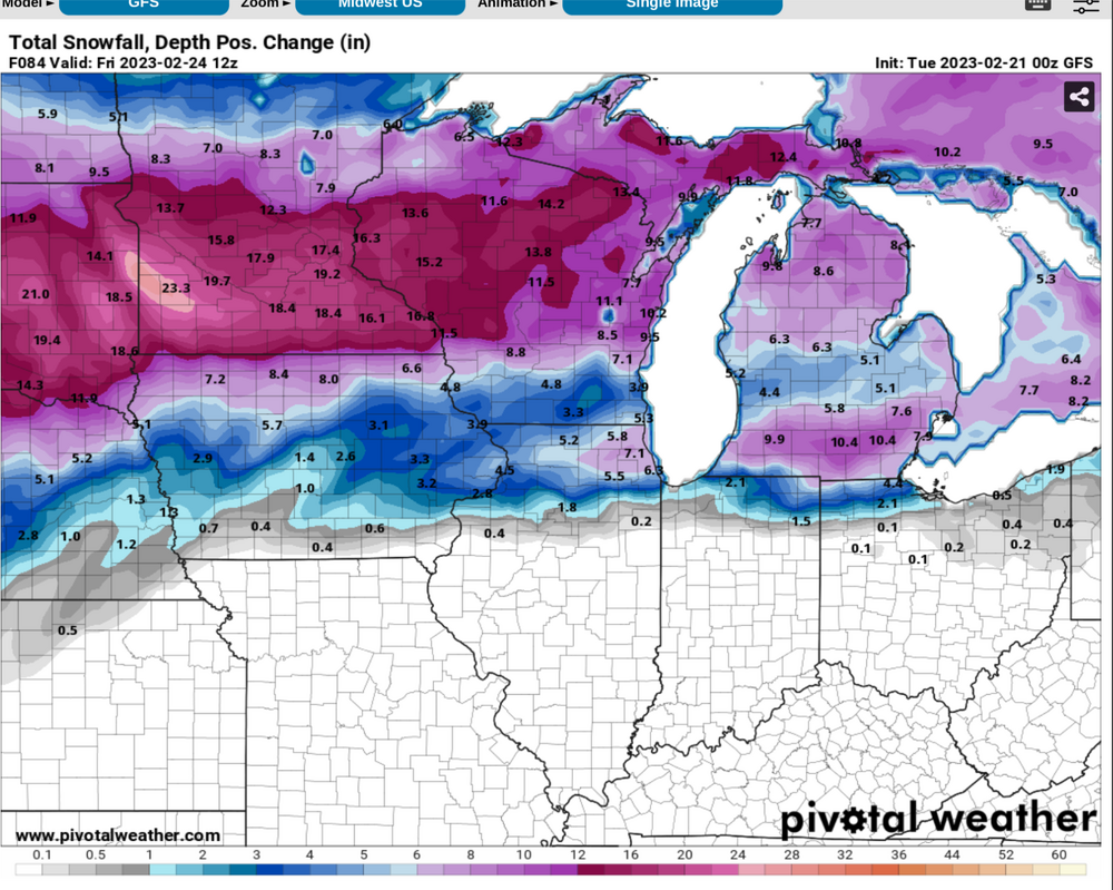
00z GFS wants to double MSP season total lol
Nino winter '23-24... we'll see how good they are next winter.

-
19 minutes ago, sielicki said:
How is the GFS still doing this phantom snowcover thing around the southern Lakes? Geez
-
5 minutes ago, MNstorms said:
Usually this type of thing happens at least once a year in the Dakotas. Nice to see Minnesota getting it for once. Also Nebraska did have a snowstorm with more than 30 inches last month.
I meant south of 42N in this sub.
-
lol at the HRRR
-
1
-
-
5 minutes ago, mimillman said:
36 degrees and 1-2” of rain is just about as miserable as it can get eh
Fwiw, I'm still running the stats on calendar days with highs in the 30s, 1"+ precip with less than 1" of snow in Chicago. Working backwards and found there were no such days in the 1990s. So it's only happened 3 times between 1990 and present.
-
1
-
-
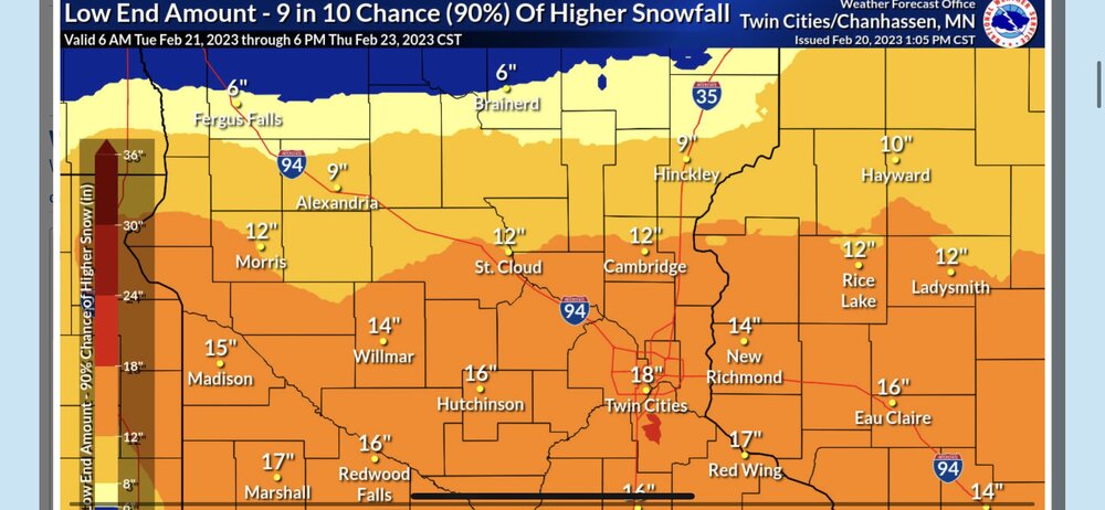
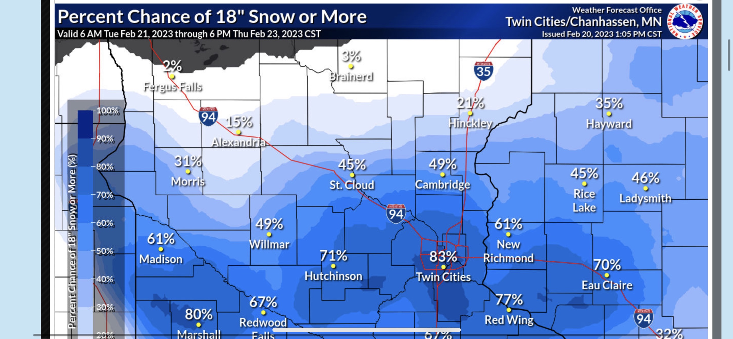
If nothing goes wrong, Minneapolis could receive more snow in this storm than anybody not in a lake effect zone south of ~42N has gotten all winter.
-
2
-
 1
1
-
-
5 minutes ago, OrdIowPitMsp said:
Minneapolis officially received 1.7” of snow with the clipper this morning. Not sure if the NWS will include that in the official storm total.
I wouldn't. There's a large break and it's not related to the upcoming system.
-
1
-
-
Unreal that it's a tie with the super El Nino year of 2015-16.
-
Here's a little something for Chicago area folks.
Since 2000, there have only been 3 occurrences of a calendar day precip of 1"+ which had less than 1" of snow/sleet and highs in the 30s. Coincidentally, 2 of those days recorded the exact same amount of precip.
Date/high/low/precip/snow amount
4/4/2003: 39/32, 1.22", 0
2/16/2006: 37/22, 1.09", T
3/24/2016: 39/30, 1.09", T
-
5 minutes ago, mnchaserguy said:
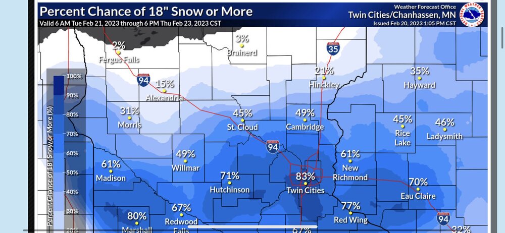
Our floor is 18”. My god. If this verifies it’ll be the biggest snowstorm I remember seeing first hand. And I’ve seen some big ones around here.
.
That's nuts. Good luck y'all.
-
1
-
-
My backyard will be a pond if the 18z NAM verifies. Takes on water at the least excuse imaginable.
-
1 minute ago, Natester said:
18z HRRR waaaaay too far north with the warm temps and way too fast with the lead low. Has the warm front along I-80 in Iowa. We'll see what the NAM says.
I feel like all is right in the world when the longer range RAP and HRRR are jacked. Feels a little weird when they aren't.
-
 1
1
-
-
22 minutes ago, sbnwx85 said:
IWX may issue one for Branch and Hillsdale in MI, too.
Those counties were mentioned in the afternoon afd, but it looks like they aren't issuing a watch.
-
4 minutes ago, sbnwx85 said:
Final call: cold rain. Going to be a doozy of an ice storm just about a county or two north though. Might be close enough to look around before work Thursday morning.
Seriously think I might nab a personal record for amount of rain with temps in the mid 30s.
-
4 minutes ago, Hoosier said:
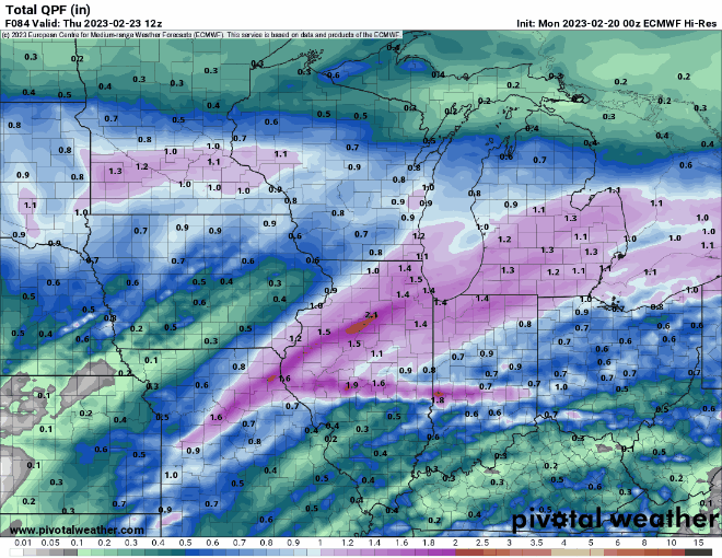
Euro really cut total qpf around Chicago northward.
-
Euro really cut total qpf around Chicago northward.
-
Maybe Ricky or somebody can clairfy this... but according to my reading of FRAM, it doesn't account for max temp (or max wet bulb temp) aloft?
Definitely have some competing factors with this ice event. Decent winds, which is a positive for offsetting the latent heat release. But heavy rates tend to not accrete well and the magnitude of the warm nose aloft won't help in areas where that's very warm.
-
48 minutes ago, WestMichigan said:
Canadian isn't too far off the GFS, but the NAM and short range models are way north.
RAP has the warm front at I-80 at 18z Wed. Not happening.
-
Somebody fix the GFS


February 21-23 Major Winter Storm
in Lakes/Ohio Valley
Posted
18z HRRR got some ice down into the I-80 corridor tomorrow morning.
There will be some dry air to play with early on (dews in the 20s) and precip onset seems to be speeding up, so I guess you never know.