

Hoosier
-
Posts
47,183 -
Joined
Content Type
Profiles
Blogs
Forums
American Weather
Media Demo
Store
Gallery
Posts posted by Hoosier
-
-
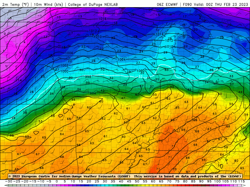
While we're wondering why the 00z Euro is running behind... I was looking back at the 18z Euro and noticed it had a window of enough cooling in far northern IL for sleet/snow.
-
4 minutes ago, RCNYILWX said:
The 00z GFS and runs before it are creating phantom snow cover in the model snow depth. In fact, the 00z run didn't initialize terribly with snow depth, but it manufactures phantom snow depth on Wednesday even though the snow accumulation algorithms are correctly not generating any snow accumulations over the southern 2/3 of IA, northern IL, northern IN, and southern lower MI.
Sent from my SM-G998U using Tapatalk
Great catch RC. Would mean to take its sfc temp output in the area with a good amount of skepticism.
In any case, shaping up to be a tricky call in parts of the metro!
-
 1
1
-
-
RGEM came in fairly amped.
-
NAM is a little weird. Bottles up a lot of precip near the frontal zone, which can occur sometimes, but it doesn't have much, if any support for something that drastic. Also makes the lead wave fairly weak as it moves across IL/IN etc. In theory that should lead to a colder solution farther north, and while it did bump colder around northern IL, it didn't really bring ice farther south elsewhere.
-
Seeing signs that the 00z NAM will tick colder/south.
-
I know of no easy way to determine this, but I wonder what the record is for liquid precip (rain or freezing rain) falling at ORD with a temp between 32-34 degrees. This might be a top 10 contender for such a thing.
-
3 minutes ago, Frog Town said:
Nice spacing with that GIF...Nice and slow for this old guy.
One needs time to take it all in.
-
 2
2
-
-
06z, 12z and 18z Euro runs valid at 00z Thursday. Can see the southward tweaks
-
1
-
-
1 minute ago, cyclone77 said:
That's def a bump south over n IL.

It took a step toward having higher pressures around the Lakes. Keep an eye on this. Could reverse on future runs or could not.
-
The GFS seems to have higher pressures around the Lakes compared to other models, which likely explains why it's getting ice a bit farther south.
In any case, there is a nice feed of cold/dry air (dews in the 20s) coming off of the high, which spells big trouble for somebody. It's just a matter of exact placement.
-
22 minutes ago, OrdIowPitMsp said:
I recommend reading the afternoon discussion from MPX. Quality weenie material.
It's nice when your floor for snowfall is a foot.
-
1
-
-
The arrival of heavier precip rates is timed better around/after dark for lower Michigan than areas farther west. Parts of Michigan will be sub 30 degrees when those heavier rates arrive. Will be an interesting battle to see how much accretes vs how much runs off, but I'd prepare for the worst.
-
20 minutes ago, sbnwx85 said:
18z GFS says maybe it’s time for me to invest in a generator.
GFS was already a colder outlier, and now it's even more outliery in that regard.
That does show something I have been wondering though. LOT's main focus for ice has been on far northern IL/near the WI border, but there's a scenario where just enough low level cold air drains into the northeast cwa, particularly Porter county, for icing potential.
-
21 minutes ago, RCNYILWX said:
If you don't want ice in the LOT CWA, a southward trend won't help us, as it would just shift the sleet and icing zones farther south across more of the metro and surrounding areas.
Need a substantial jump south to get significant snow into the CWA, which seems rather unlikely at this point. Still certainly enough time for adjustments north and south in the "wintry mess" zone though. The 12z EPS for instance did nudge south on Wednesday-Wednesday evening with the 850 mb warmth, plus the surface low/trough and front position, while the GEFS nudged slightly north.
These 12z changes notwithstanding, I'd hedge south with the frontal position on Wednesday, as long as the lead surface wave remains flatter. The warm sector will be potent for this time of year, but plenty of precip in the vicinity of the front, plus the cooler dense air north of the front often wins out even in spring setups, while in this case the air mass north will be supplied by 1035+ mb high pressure to the north.
Makes sense. Honestly I feel like if we do see adjustments from here on out, it's more likely to be south and not north. But it's wx so who knows lol
-
For much of the icing area, it looks like there is about a 3-6 hour window between temps going above freezing and the onset of the stronger winds on Thursday. Melting off of the trees should be fairly slow until it can get several degrees above freezing and into the 40s. Where significant ice accrual occurs, that is likely not going to be enough time to melt off a lot of ice prior to arrival of stronger winds. But small details like this will matter.
-
6 minutes ago, SchaumburgStormer said:
Waiting for model weakening and qpf lowering, as is tradition
Early indication of a southward nudge on the 18z NAM.
-
59 minutes ago, SolidIcewx said:
On the plus side for I94 folks and north is that it goes to rain and warms into the upper 40s before it drops again Thursday night
That's true, but the reason it could get that warm is because of the approach of the second low. The winds ramp up with that, which could lead to a window post-icing where it's very windy on ice-stressed trees before it all has a chance to melt.
-
2
-
-
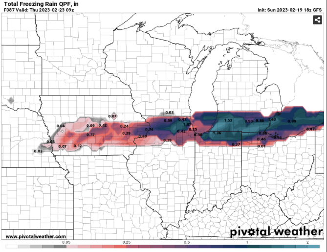
To see Euro FRAM with amounts like that is concerning, especially for Michigan. That being said, still some time for changes.
-
2 minutes ago, ILSNOW said:
why is there a big difference between the 2 ?

Basically FRAM actually tries to figure out how much ice accrual there will be, vs the other map which is just qpf at temps 32 and below.
-
5 minutes ago, cyclone77 said:
The models seem unusually consistent so far in the placement of the heavy snow swath from MN to MI. Why can't they be like that for us poor folks further south?

I keep thinking it would be comical if we start to see more model divergence in the next day or two... considering how seemingly locked in this thing has been.
-
15 minutes ago, ILSNOW said:
scary ice numbers over Michigan

Can you post the FRAM version?
-
8 minutes ago, ILSNOW said:
agree here is the sounding for the area that it paints 8 inches of snow (soundings indicate freezing rain)

That sounding says valid next Saturday?
-
This mid-level jet is a freakshow. 500 mb winds of 130-140 kts on Thursday. Hardly ever see that in this region, with the most notorious occurrence probably being on 4/11/1965. To be clear, I'm not predicting an outbreak like that or anything close to it. Only comparing the wind speeds.
Thursday is sort of an atypical high wind setup with a relatively modest surface low (maybe not much below 1000 mb) and lack of a stronger surface high. So much wind aloft though and the pressure gradient that we do have is packed in pretty nicely.
-
22 minutes ago, ILSNOW said:
12z UKMET is much colder than other models

Something seems off about that. Based on the 850 mb temp maps, there shouldn't be that much snow that far south.
February 21-23 Major Winter Storm
in Lakes/Ohio Valley
Posted
00z Euro still has a window of sleet and snow in far northern IL. It actually rips for a while.