Hoosier
-
Posts
47,183 -
Joined
Content Type
Profiles
Blogs
Forums
American Weather
Media Demo
Store
Gallery
Everything posted by Hoosier
-

The August 21, 2017 Great American Eclipse
Hoosier replied to ice1972's topic in Weather Forecasting and Discussion
The 12z GFS seems more favorable for Nebraska than Missouri. I would not get too hung up on individual runs yet. I really don't want to have to go out to Nebraska (mainly because I want to arrive home at a reasonable hour on Monday night and I'm assuming traffic will be heavy leaving the eclipse) but am prepared to do it if necessary. -
The August 21, 2017 Great American Eclipse
Hoosier replied to ice1972's topic in Weather Forecasting and Discussion
Gotta like the 12z GFS. Limited clouds almost perfectly overlaying the path of totality from eastern Nebraska to Tennessee. -
The August 21, 2017 Great American Eclipse
Hoosier replied to ice1972's topic in Weather Forecasting and Discussion
There's very convenient interstate access into southern IL from Chicago, Milwaukee, etc. so my guess is that the first choice for most of that crowd is going to be southern IL or thereabouts. -
The August 21, 2017 Great American Eclipse
Hoosier replied to ice1972's topic in Weather Forecasting and Discussion
This stuff is so high stakes. If totality lasted a couple hours there'd be a lot more margin for error. We can model watch ourselves to death but it only goes so far. Get some poorly located/timed clouds even on a "mostly sunny" day and you're screwed, unless you just want to see how dark it can get in the middle of the day.. -
The August 21, 2017 Great American Eclipse
Hoosier replied to ice1972's topic in Weather Forecasting and Discussion
Here's the cloud cover map valid same time. Been closely following the model runs ever since this got in range (especially for the Plains/Midwest region), and after absorbing all these runs, I will be pleasantly surprised if there aren't some cloud concerns somewhere in that region. That is a general takeaway that I'm getting even though there's the usual variance on specific details. -
The August 21, 2017 Great American Eclipse
Hoosier replied to ice1972's topic in Weather Forecasting and Discussion
Surprisingly there's a free site that offers it. https://weather.us/model-charts/euro/illinois/total-cloud-coverage/20170821-1800z.html 12z run looks decent. I wish it would be less than 1% though haha -
The August 21, 2017 Great American Eclipse
Hoosier replied to ice1972's topic in Weather Forecasting and Discussion
Models have cloud cover output maps. At the College of Dupage website, it's located under the Precipitation Products menu on the left side. Here is the 12z GFS at 1 pm central time on the 21st -
The August 21, 2017 Great American Eclipse
Hoosier replied to ice1972's topic in Weather Forecasting and Discussion
This is nice... various carriers will be deploying extra cell towers http://abcnews.go.com/amp/Technology/wireStory/cellphone-service-spotty-rural-eclipse-watchers-48933813 -
The August 21, 2017 Great American Eclipse
Hoosier replied to ice1972's topic in Weather Forecasting and Discussion
^ To add to that, do not rely on technology like the internet and GPS to get to your viewing location. You never know if systems may be become overloaded. I will be bringing a paper map with the totality duration lines overlaid. -
The August 21, 2017 Great American Eclipse
Hoosier replied to ice1972's topic in Weather Forecasting and Discussion
Question for dtk or someone else with intimate knowledge of the models. Does NWP make any attempt to account for the loss of incoming sunlight during an eclipse and thus, the temperature decrease that commences shortly before totality? I know that it's pretty common to have temperature drops on the order of 5-15 degrees depending on time of day and other factors. -
The August 21, 2017 Great American Eclipse
Hoosier replied to ice1972's topic in Weather Forecasting and Discussion
The maximum duration of totality in the 2024 eclipse is just under 4 1/2 minutes, in Mexico. Areas near the center line in the US will have totality lasting over 3 minutes to, in some cases, just over 4 minutes. -
The August 21, 2017 Great American Eclipse
Hoosier replied to ice1972's topic in Weather Forecasting and Discussion
I'll admit the traffic has me concerned. It's the big question as we've never had something like this in the US in modern times with so much of the population being within driving distance of totality. Originally, I got my room near STL just in case the weather was looking bad in the MO/KY/IL area and I'd have to drive out to Kansas/Nebraska on the morning of the 21st, but I'm wondering if I should just head down the day before no matter what. With normal traffic, I could leave my house and get into the eastern MO/IL/western KY portion in about 5-6 hours, but it won't be normal. -
The August 21, 2017 Great American Eclipse
Hoosier replied to ice1972's topic in Weather Forecasting and Discussion
Did you look for a hotel outside the path of totality? I was able to get one for a reasonable/normal rate about a mile outside the zone (near St. Louis). Like you said, a lot of stuff in the path is a higher price/already booked. -
Man that's brutal!
-
Texas/New Mexico/Louisiana/Mexico Obs And Discussion Thread Part 8
Hoosier replied to wxmx's topic in Central/Western States
Sorry folks. There was stuff being posted all over the board. -
Devastating tornado strikes Joplin, Missouri
Hoosier replied to Hoosier's topic in Weather Forecasting and Discussion
Couple images from SPC from that day. I do remember the focus/target area that day being pretty broad. Then attention quickly shifted toward Joplin. -
Devastating tornado strikes Joplin, Missouri
Hoosier replied to Hoosier's topic in Weather Forecasting and Discussion
Can't imagine being so close to total devastation as you were. You were in the outer fringes of the tornado IIRC? -
What happened in that event? Was it a case of completely missing the lake effect potential or just being off with the placement of the band?
-
great pic!
-
beavis, I found a wind chill of -58F for ORD on 12/24/1983. Temp was -25F with wind of 25 mph
-
February 1936 might also be worth checking. It was ridiculously cold especially in the northern Plains/upper Midwest.
-
Thanks for the info. Where did you find it?
-
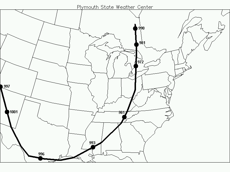
There was easily a 40-50 mb pressure gradient with that storm, so it must've been pretty windy. I was working on a blizzard project a while back but gave it up due to the workload...anyway one of the storms I was working on was 1/12/1918. Here is the approximate track and strength at various points. Numbers could be a bit off since I converted from inches to mb but should be pretty close.
-
Related to this...here is a study about the frequency of various wind chill readings in the northern US. http://www.crh.noaa.gov/crh/ssd/pdf/tsp_15.pdf Too bad they didn't do a map for wind chills of -50 or -60.
-
I don't know where to get hourly data from back then.