

sbnwx85
-
Posts
1,783 -
Joined
-
Last visited
Content Type
Profiles
Blogs
Forums
American Weather
Media Demo
Store
Gallery
Everything posted by sbnwx85
-

Pre-Christmas (Dec 21-23rd) Winter Storm Part 2
sbnwx85 replied to Chicago Storm's topic in Lakes/Ohio Valley
Couple inches in the ground. Wind is causing drifting but not horrible. I drove through a snow devil on my way home which was cool. Flake size increases dramatically under lake effect bands. If that can get going there will be some good totals and true blizzard conditions tomorrow.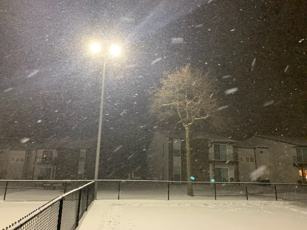
-
Pre-Christmas (Dec 21-23rd) Winter Storm Part 2
sbnwx85 replied to Chicago Storm's topic in Lakes/Ohio Valley
Latest thoughts from IWX: .Update...(Tonight) Issued at 900 PM EST Thu Dec 22 2022 GOES vapor shows intense mid level sw digging through se MO attm with bombing sfc cyclone near KTOL. Swath of heaviest snow had shifted east into wrn OH in association with intense fgen burst along sharp arctic front. Meanwhile post frontal locations were plummeting with nearly all of IL below zero now. Sat/radar trends show lake streamers now into nw zones and enhancing ongoing snow. Of note is additional tilting of upper trough and expect additional enhancement of wrn extent of snow shield from srn IL nwd into nw IN this evening. Thus given more favorable thermal profile with time expect another 1-2" of snow for most outside lake belt likely overnight. This will occur coincidental with further deepening of sfc cyclone toward lake Huron and yield steadily increasing west/nwrly winds with gusts pushing 40kts by daybreak. Thus conditions will deteriorate further overnight. Travel is strongly discouraged as life threatening cold and near blizzard conditions develop. Otherwise prior forecast remains in tip top shape with no changes needed. -
Pre-Christmas (Dec 21-23rd) Winter Storm Part 2
sbnwx85 replied to Chicago Storm's topic in Lakes/Ohio Valley
Measure 1.8" at work. -
Pre-Christmas (Dec 21-23rd) Winter Storm Part 2
sbnwx85 replied to Chicago Storm's topic in Lakes/Ohio Valley
Pixie dust flying. Down to 21 degrees. Wind has picked up but not too bad yet. -
Pre-Christmas (Dec 21-23rd) Winter Storm Part 2
sbnwx85 replied to Chicago Storm's topic in Lakes/Ohio Valley
Still 32 degrees and snowing moderately. Good banding trying to form. Closing in on an inch. -
Pre-Christmas (Dec 21-23rd) Winter Storm Part 2
sbnwx85 replied to Chicago Storm's topic in Lakes/Ohio Valley
Light snow has commenced. -
Pre-Christmas (Dec 21-23rd) Winter Storm Part 2
sbnwx85 replied to Chicago Storm's topic in Lakes/Ohio Valley
Indiana Department of Homeland Security is deploying military personnel to help drivers who get stuck on the Indiana Toll Road starting tonight. -
Pre-Christmas (Dec 21-23rd) Winter Storm Part 2
sbnwx85 replied to Chicago Storm's topic in Lakes/Ohio Valley
Based on social media comments on my station's pages, people aren't quite grasping the seriousness of this. They're getting caught up on snow amounts, most saying it won't be that bad. I'm sure many are going to push it to make it home for Christmas. It's going to be a long weekend for first responders. -
Pre-Christmas (Dec 21-23rd) Winter Storm Part 2
sbnwx85 replied to Chicago Storm's topic in Lakes/Ohio Valley
10" seems reasonable here. Areas in Berrien County. MI should hit 16" or more. This is essentially an monster arctic front turned into a long duration lake effect event on steroids. -
Pre-Christmas (Dec 21-23rd) Winter Storm Part 2
sbnwx85 replied to Chicago Storm's topic in Lakes/Ohio Valley
-
Pre-Christmas (Dec 21-23rd) Winter Storm Part 2
sbnwx85 replied to Chicago Storm's topic in Lakes/Ohio Valley
Cheyenne just dropped 40 degrees in one hour.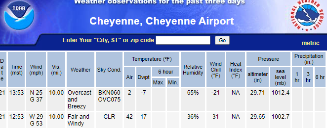
-
Pre-Christmas (Dec 21-23rd) Winter Storm Part 2
sbnwx85 replied to Chicago Storm's topic in Lakes/Ohio Valley
I wouldn't be surprised. The lake effect is going to be reaching far inland. Plus, ground blizzard conditions should occur if winds do indeed verify. -
Pre-Christmas (Dec 21-23rd) Winter Storm Part 2
sbnwx85 replied to Chicago Storm's topic in Lakes/Ohio Valley
Knowing how the HRRR overdoes lake-effect amounts I'm very excited to see what it spits out. -
Pre-Christmas (Dec 21-23rd) Winter Storm Part 2
sbnwx85 replied to Chicago Storm's topic in Lakes/Ohio Valley
SREF plume for SBN just went up to 20 inches by Saturday morning -
Pre-Christmas (Dec 21-23rd) Winter Storm Part 2
sbnwx85 replied to Chicago Storm's topic in Lakes/Ohio Valley
My first Blizzard Warning in almost exactly 10 years. Excuse me while I weenie. -
Pre-Christmas (Dec 21-23rd) Winter Storm Part 2
sbnwx85 replied to Chicago Storm's topic in Lakes/Ohio Valley
Hoping everyone is preparing for possible power outages with this system and frigid cold...even areas that don't get a lot of snow. We lost power during the November 5th wind event with winds between 60 and 70 mph. This event won't be as strong but with the cold temps any power outages could become a big problem if you can't keep warm. -
Pre-Christmas (Dec 21-23rd) Winter Storm Part 2
sbnwx85 replied to Chicago Storm's topic in Lakes/Ohio Valley
INDOT tweeted this out: -
Pre-Christmas (Dec 21-23rd) Winter Storm Part 2
sbnwx85 replied to Chicago Storm's topic in Lakes/Ohio Valley
Big, if true. -
Pre-Christmas (Dec 21-23rd) Winter Storm Part 2
sbnwx85 replied to Chicago Storm's topic in Lakes/Ohio Valley
I'm starting to come around to the ICON. -
Pre-Christmas (Dec 21-23rd) Winter Storm
sbnwx85 replied to Chicago Storm's topic in Lakes/Ohio Valley
SBN still in the game for possible double digit totals. Berrien County, just to our north, might be the best place to get blizzard conditions locally. -
Pre-Christmas (Dec 21-23rd) Winter Storm
sbnwx85 replied to Chicago Storm's topic in Lakes/Ohio Valley
The scene from South Bend. -
Pre-Christmas (Dec 21-23rd) Winter Storm
sbnwx85 replied to Chicago Storm's topic in Lakes/Ohio Valley
Despite the shift I’m still in the bullseye. I’m holding my breath on every run. -
Pre-Christmas (Dec 21-23rd) Winter Storm
sbnwx85 replied to Chicago Storm's topic in Lakes/Ohio Valley
Behind the scenes. Assignment Editor nightside. I used to be on air for a radio station in Jacksonville, IL. I covered one blizzard warning there in 2012 but it was for quick hit that brought blizzard conditions for about two hours. It was exciting but I’m really looking forward to a longer-duration blizzard. -
Pre-Christmas (Dec 21-23rd) Winter Storm
sbnwx85 replied to Chicago Storm's topic in Lakes/Ohio Valley
I have yet to cover a true blizzard while working in TV news. We’re already asking crews who were off Friday to come into work. I usually work 1 pm to 10 pm, but I have a feeling I’ll be starting my Friday much earlier and ending it sometime late on Saturday. -
Pre-Christmas (Dec 21-23rd) Winter Storm
sbnwx85 replied to Chicago Storm's topic in Lakes/Ohio Valley
Reds*


